SnoSki14
-
Posts
16,194 -
Joined
-
Last visited
Content Type
Profiles
Blogs
Forums
American Weather
Media Demo
Store
Gallery
Everything posted by SnoSki14
-
I don't buy the lighter precip with an intensifying storm. That seems to be a big difference between the snowier models vs the less snowy ones
-
Someone's getting 3-4"+ rates and thundersnow. The frontogenesis is ridiculous
-
I'm looking at 18hrs out and I can assure it won't lol
-
The NWS & Mt. Holly have a lot of updating to do tomorrow.
-
I remember Tombo. Those play by plays of Boxing Day were awesome
-
They will be
-
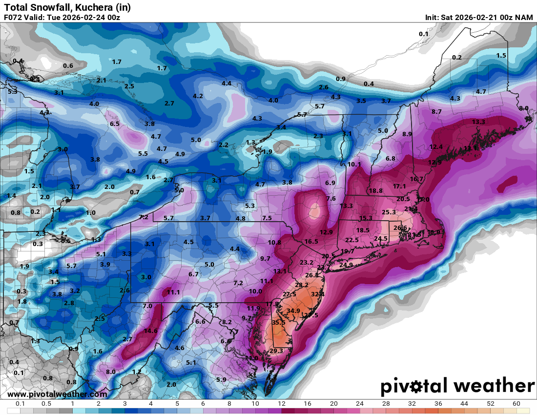
Feel quite good being in central NJ. The trend from the Nam has been northward ticks. This could put the jackpot zone closer to this area and likely closer to NYC as well.
-
Parts of Southern NJ pushing 3 feet. That's nuts
-
If it's correct then people are not ready for what's coming
-
That wouldn't surprise me. Often it starts faster than expected and ends earlier than forecast.
-
As long as it's a strong, dynamic system then I prefer a very tucked in track maybe 50-75 miles SE of ACY
-
Yes it was.
-
I still can't believe the GFS OP pulled this off.
-
Let's keep our expectations in check though. Remember NAM struggles mightily beyond 36-48hrs, we're just entering its more accurate range.
-
Correct. Whatever hundredths of QPF we lose to a mix won't matter once the storm gets going.
-
Um no lol
-
Well when you keep weening out over every storm eventually you'll be right.
-
Good point. Imagine the panic tomorrow if warnings go up for 12-18"+
-
Is the public really aware of this. I know they generally expect snow just from talking to people but I feel the hype has been far less than the Jan storm.
-
If it follows that playback then amounts will keep going up until start time
-
I saw that and was in awe. I don't recall seeing a 60-72 hour ensemble prog that strong. The true scope of what's unfolding may not even be apparent yet if that's correct.
-
Because it's not done trending yet.
-
It tends to be more suppressed in general. Odd outputs sometimes. I remember with the Jan storm it kept spewing 3-4" totals over NYC and into my region too vs the 10"+ amounts we got.
-
Having a 3 day ensemble mean have a 976 low is crazy.
-
GEFS look really good