

Kmlwx
-
Posts
13,592 -
Joined
-
Last visited
Content Type
Profiles
Blogs
Forums
American Weather
Media Demo
Store
Gallery
Everything posted by Kmlwx
-
Sign me up for a severe t'storm day.
-
I always mention this - but anecdotally these convective lines are well know for coming in a bit earlier than progged at range.
- 1,378 replies
-
- 2
-

-
- severe
- thunderstorms
- (and 2 more)
-
Here's the LWX disco from that day .MESOSCALE... WATER VAPOR LOOP EARLY THIS MORNING PLACES A STRONG UPPER LOW ACROSS THE TENNESSEE VALLEY...MOVING TO THE NORTHEAST. A PRONOUNCED DRY SLOT IS PENETRATING WEST VIRGINIA AND SOUTHWEST VIRGINIA FROM THE WEST. 13Z SURFACE MESOANALYSIS PLACES A 993MB OCCLUDED CYCLONE IN SOUTHERN INDIANA...WITH THE OCCLUDED/COLD FRONT CUTTING THROUGH CENTRAL WEST VIRGINIA SOUTHEAST THROUGH THE CENTRAL CAROLINAS. A WARM FRONT IS PUNCHING NORTH INTO CENTRAL VIRGINIA...STALLING IN THE VICINITY OF THE WEST COAST OF THE CHESAPEAKE BAY. RUC MODEL INDICATES TONGUE OF RICH PRECIPITABLE WATER VALUES IS MOVING NORTH ALONG THE BLUE RIDGE (INCREASING FROM 12Z RAOB VALUES OF 1.3" TO 1.7"). MEANWHILE...DRY SLOT ALOFT IS OVERRUNNING RICH BOUNDARY LAYER MOISTURE...WHICH SHOULD INCREASE INSTABILITY AND CONVECTIVE UPDRAFT STRENGTH. GIVEN RICH PRECIPITABLE WATER VALUES AND DEWPOINTS JUST BEHIND THE OCCLUDED/COLD FRONT...CURRENT THINKING IS STRONG CONVECTIVE LINE WILL DEVELOP ALONG THE BOUNDARY WEST OF CURRENT PRECIPITATION. ROTATING STORMS WILL BE POSSIBLE IN SOUTH TO NORTH LINE SEGMENTS AHEAD OF THE COLD FRONT. SHEAR INDICES ARE QUITE HIGH TODAY. WIND PROFILES OBSERVED ON KLWX WIND PROFILE INDICATE SOUTHEAST WINDS 25 KNOTS AT 1KFT...INCREASING TO 60 KNOTS FROM THE SOUTH AT 3KFT. 06Z GFS BUFKIT FORECAST SOUNDINGS INDICATE 0-1 HELICITY GREATER THAN 200 M2/S2 AND 0-1KFT SHEAR OF 40 KNOTS THIS AFTERNOON...ESPECIALLY ACROSS CENTRAL VIRGINIA AND LOWER SOUTHERN MARYLAND. GIVEN ABOVE...THINKING THERE IS A POSSIBILITY FOR MULTIPLE TORNADOES ACROSS THE REGION THIS AFTERNOON. LOCALLY DAMAGING WINDS WILL OCCUR IN VICINITY OF STRONGEST UPDRAFTS. ANOMALOUSLY HIGH PRECIPITABLE WATER VALUES MAY PRODUCE LOCALIZED FLASH FLOODING. GFS IS PREFERRED MODEL AT THIS TIME GIVEN RECENT ISSUES WITH THE NAM (OVER-DEEPENING TROUGHS IS SLOWING DOWN TIMING OF COLD FRONT). &&
- 1,378 replies
-
- 2
-

-
- severe
- thunderstorms
- (and 2 more)
-
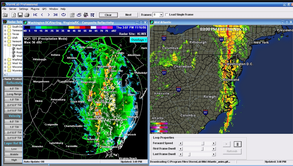
Found this screen cap I took. It was Nov 16, 2006. Haven't looked at H5 yet so it may not even be a close match - but anecdotally that's my high water level for Oct/Nov severe potential.
- 1,378 replies
-
- 2
-
-
- severe
- thunderstorms
- (and 2 more)
-
It's really one of those times when I might be "in" just purely based on the dynamics. Even without moisture it has the feels of one of those very gust shower lines...and more upside potentially. I think there was a really potent storm system in like November 2006 that did some fun stuff around these parts
-
It has my eye for sure - if a nice low pressure can be in the vicinity - fun things can happen even outside of peak heating. And honestly....I think peak heating becomes a lot less important this time of year and with a dynamic system.
-
0z Euro in the long range had Sandy Jr-esque 500mb look...
-
Saw a fireball this morning while driving NWish on MD-32 around 3:26am. Got a video and sent a report to https://www.amsmeteors.org/ - neat!
-
Always bet on Fuijiwhara
-
I have the WS-5000 and have had no complaints. In fact, with Energizer Lithium batteries I somehow have yet to have to change ANY of the sensor batteries...and it's been over 2 years I think. Has to happen eventually....they just keep going. I have a few temp sensors, a lightning one. Never installed the rain gauge because I don't have a good spot, and the wind direction is unreliable because it's not sighted properly - but for everything else it's been fantastic. The power supply for the console went haywire and died recently but got an Amazon replacement and it went back to normal.
-
NAM nest and HRDPS seem to be the most enthused. Some of the other CAMs seem pretty underenthused. We'll see - if nothing else another ground wetting for many seems likely.
- 1,378 replies
-
- 3
-
-
- severe
- thunderstorms
- (and 2 more)
-
Wake up folks! Day 2 marginal from SPC, NCAR AI and CSU MLP look decent for tomorrow as does NAM nest sim reflectivity. This might be the last hurrah of the season...omitting any pencil thin squall line like we often get in fall.
- 1,378 replies
-
- 2
-
-
- severe
- thunderstorms
- (and 2 more)
-
I wouldn't rule anything out of course at this phase. So much usually depends on how disorganized it stays (or the opposite). Certainly if it gets stronger quicker I'd favor the classic recurve. Those tracks at least leave a low probability door open for something to get closer than most of the tracks would indicate. If nothing else, seems like the Atlantic is stirring at a minimum.
-
I would have totally expected Virginia to be higher on the list if for no other reason than more area.
- 1,378 replies
-
- 1
-
-
- severe
- thunderstorms
- (and 2 more)
-
In summer's past - 65 degree dewpoints would be starting to get muggy. After at, or above 80 degree dewpoints...65-67 feels like fall air
-
The radar is reminding me of some of the Local on the 8s classic squall lines on the low-res local radar from the 1990s.
-
Some backbuilding/training of those MoCo cells. Area from around Great Falls to Kensington and Sligo Creek areas are in trouble if this keeps up. Really bad spot to have training storms.
-
Downburst/microburst signal on the Montgomery County cell it looks like.
-
I know a lot of our days in past summers, the dewpoint gets ticked downwards a bit by downsloping winds. Seems perhaps that has been largely missing this year?
-
Pigs are flying, folks!!!! Man your battlestations!
- 1,378 replies
-
- 4
-

-
- severe
- thunderstorms
- (and 2 more)
-
My money is on flooding being the biggest risk with 1) Antecedent conditions and 2) The saggy front aspect.
- 1,378 replies
-
- 1
-
-
- severe
- thunderstorms
- (and 2 more)
-
Saggy fronts that get hung up and just sort of slowly move through tend to be big rain producers for us sometimes - especially when they act as "train tracks" for repeated clusters/lines of storms. The ground is definitely primed for flooding already. Stream near me has had two 8+ft crests in the past few weeks. If the tropics ever wake up this year and decide to threaten the east coast, some parts of the area are pretty darn waterlogged...could be a big event.
- 1,378 replies
-
- 3
-
-
- severe
- thunderstorms
- (and 2 more)
-
Kind of outside of our normal "big severe" window. This is usually when we get stuck in pulse severe season. But yes - I agree. At range there's so many things that could temper the threat though. I have on eye on it for now - we'll see how things look as the weekend starts. I'll be watching the AI severe pages for trends.
-
LWX in their early morning AFD seems potentially excited about severe potential into next week. SPC also has a good discussion on their D4-8 outlook. We'll have no clarity on details until closer to next week - but bears watching.
- 1,378 replies
-
- 1
-
-
- severe
- thunderstorms
- (and 2 more)
-
62.8 with a dewpoint in the lower 60s. SO much better.


