Kmlwx
-
Posts
13,552 -
Joined
-
Last visited
Content Type
Profiles
Blogs
Forums
American Weather
Media Demo
Store
Gallery
Everything posted by Kmlwx
-
While MLLR aren't "good" - they also aren't as paltry as some of our other events.
-
Slight risk removed.
-
15z HRRR sends a nice cluster through after 0z. Funny because HRRR tends to undergo storms (at least previously when it would have dews too low)
- 1,378 replies
-
- 2
-

-
- severe
- thunderstorms
- (and 2 more)
-
PWS is reporting 66.4 on the temp and 65.8 on the dew point. Pretty saturated surface airmass! And soupy for this time of year! Other than storm fuel - really not looking forward to 70+ dew point season.
-
CAPE inching upward in a little "tongue" where the front may have cleared. Nearly touching Southern Maryland.
-
It's seems like one of those weird conditional severe days where coverage is low, and who knows if we'll even see any storms pop during peak time - but if one goes up it could really dominate even if isolated.
- 1,378 replies
-
- 3
-
-
- severe
- thunderstorms
- (and 2 more)
-
I'm pretty close to calling you out as a meteorology AI robot. You always have superb explanations and insight. We're watching you though....robot.
- 1,378 replies
-
- 4
-
-

-
- severe
- thunderstorms
- (and 2 more)
-
It was pretty darn misty and damp out there this morning on the way to work. I'm closer to meh-ing than I am to "woo storms-ing" lol
- 1,378 replies
-
- 1
-

-
- severe
- thunderstorms
- (and 2 more)
-
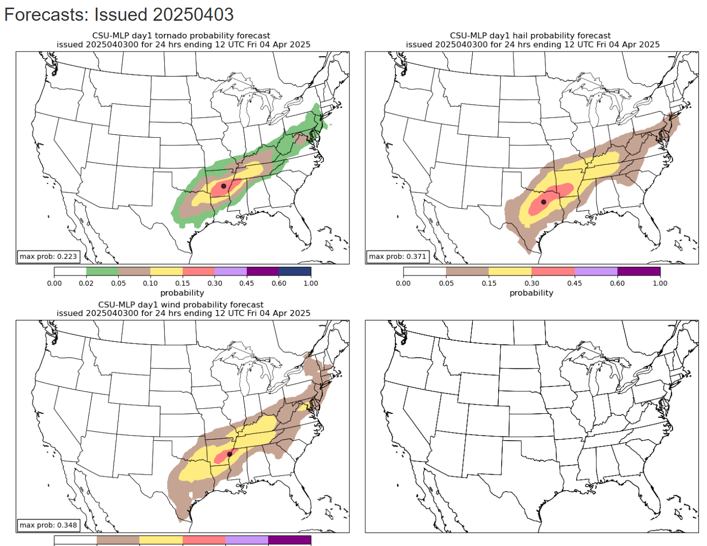
CSU MLP for today

- 1,378 replies
-
- 4
-
-
- severe
- thunderstorms
- (and 2 more)
-
Goes north of me but that HRRR run looks pretty good for storms.
-
18z NAM and NAM nest continue with the theme of no initiation/storms for Thur. Parameters look a bit worse than prior runs as well. Still worth watching.
-
12z CSU MLP maps

- 1,378 replies
-
- 2
-
-
- severe
- thunderstorms
- (and 2 more)
-
And my excuse of "it's still early in the season" gets less relevant each passing day. By April, we often have much better thermodynamic profiles - though May/June would be even better. Though that admittedly won't solve mid-level lapse rates! I will say - yesterday ahead of the storms did feel juicier than the prior few events this year so far. So we are "getting there" in terms of better dew points and temps. One thing I do like is that we haven't had a shortage of "chances" this year so far. While there has sometimes been a week+ between risks, there's been a pretty steady stream of at least potential systems showing up. Thursday has my interest at least for now.
- 1,378 replies
-
- 3
-
-
- severe
- thunderstorms
- (and 2 more)
-
NAM and NAM nest seem better with parameters for Thursday now - but sim reflectivity doesn't really have any initiation at least on the panels I've seen (through 0z Fri).
-
TBWI shows outflow moving out ahead of the storms.
-
One nice thing is that the Warn on Forecast domain includes us. More model runs to wring our hands over!!!
-
Well if nothing else the 12z IAD sounding has 754 surface CAPE already. Seems likely many of us will see rain/thunder at a minimum today. Side note - it's weird seeing the swath of missing soundings.
-
1730z D2 is out. Not many changes.
- 1,378 replies
-
- 1
-
-
- severe
- thunderstorms
- (and 2 more)
-
Instability for next Monday improved on the Euro it seems. Timing also seems to look a bit better on the GFS.
- 1,378 replies
-
- 2
-
-
- severe
- thunderstorms
- (and 2 more)
-
They are just so unusual and finicky - and they often are super cagey at range. And the best we can *usually* hope for is a modified EML that loses a lot of punch as it gets to use. The "big events" are the ones that really have a robust one. I haven't done a deep dive - but I'm guessing June 2008 had one, we all know June 2012 had one. Minus an EML - tropical action going to our west is always a good bet for tornadoes.
- 1,378 replies
-
- 1
-

-
- severe
- thunderstorms
- (and 2 more)
-
Way out there of course - but the 12z GFS pushes the system through too early in the day I think,
-
It could be July/August and we'd find a way to cloud over just in time to squash instability
-
That discussion indicates we will have similar issues to our prior severe "threats" this year so far. Thermodynamics likely to be lacking. Though again - the further we get into spring, the "easier" it gets to not get wedged in...though if you ask Eskimo Joe you can probably still count on getting wedged in even into June lol.
-
It would be so fitting.
-
Sub-severe gusty showers possible on Thursday afternoon/evening.