

Kmlwx
-
Posts
13,552 -
Joined
-
Last visited
Content Type
Profiles
Blogs
Forums
American Weather
Media Demo
Store
Gallery
Everything posted by Kmlwx
-
The radar is reminding me of some of the Local on the 8s classic squall lines on the low-res local radar from the 1990s.
-
Some backbuilding/training of those MoCo cells. Area from around Great Falls to Kensington and Sligo Creek areas are in trouble if this keeps up. Really bad spot to have training storms.
-
Downburst/microburst signal on the Montgomery County cell it looks like.
-
I know a lot of our days in past summers, the dewpoint gets ticked downwards a bit by downsloping winds. Seems perhaps that has been largely missing this year?
-
Pigs are flying, folks!!!! Man your battlestations!
- 1,378 replies
-
- 4
-

-
- severe
- thunderstorms
- (and 2 more)
-
My money is on flooding being the biggest risk with 1) Antecedent conditions and 2) The saggy front aspect.
- 1,378 replies
-
- 1
-

-
- severe
- thunderstorms
- (and 2 more)
-
Saggy fronts that get hung up and just sort of slowly move through tend to be big rain producers for us sometimes - especially when they act as "train tracks" for repeated clusters/lines of storms. The ground is definitely primed for flooding already. Stream near me has had two 8+ft crests in the past few weeks. If the tropics ever wake up this year and decide to threaten the east coast, some parts of the area are pretty darn waterlogged...could be a big event.
- 1,378 replies
-
- 3
-
-
- severe
- thunderstorms
- (and 2 more)
-
Kind of outside of our normal "big severe" window. This is usually when we get stuck in pulse severe season. But yes - I agree. At range there's so many things that could temper the threat though. I have on eye on it for now - we'll see how things look as the weekend starts. I'll be watching the AI severe pages for trends.
-
LWX in their early morning AFD seems potentially excited about severe potential into next week. SPC also has a good discussion on their D4-8 outlook. We'll have no clarity on details until closer to next week - but bears watching.
- 1,378 replies
-
- 1
-
-
- severe
- thunderstorms
- (and 2 more)
-
62.8 with a dewpoint in the lower 60s. SO much better.
-
That storm coming down the Potomac looks healthy and supercellular.
- 1,378 replies
-
- 1
-
-
- severe
- thunderstorms
- (and 2 more)
-
Same general setup here. On a hill and away from the trail by a good bit. Can definitely hear the roar of the stream/creek when it gets high though. My friends and I found a fish well up into the branches of a tree after the June 2006 flooding. I don't think I've seen water levels that high since then.
-
My PWS is reporting an 80 degree dewpoint....has happened several times this summer already...awful.
-
NW Branch up near Kemp Mill - I use this site to monitor - https://waterdata.usgs.gov/monitoring-location/USGS-01650500/#period=P7D&showMedian=true&dataTypeId=continuous-00065-0
- 1,378 replies
-
- 1
-
-
- severe
- thunderstorms
- (and 2 more)
-
Yeah - he's mostly fine when he sticks to just the facts...also when he isn't blocking a lane of travel on a road
-
Good lord they look like they are on steroids! What a harvest!
-
12z HRRR blows up robust convection for the DC/Baltimore corridor especially in the 0-2z timeframe. PWATS near 2 inches in parts of the area...would think flooding risk with this activity - even if not super slow moving. Creek near the house rose to around 8ft during the other night's heavy rainfall. Highest in the past few years.
- 1,378 replies
-
- 1
-
-
- severe
- thunderstorms
- (and 2 more)
-
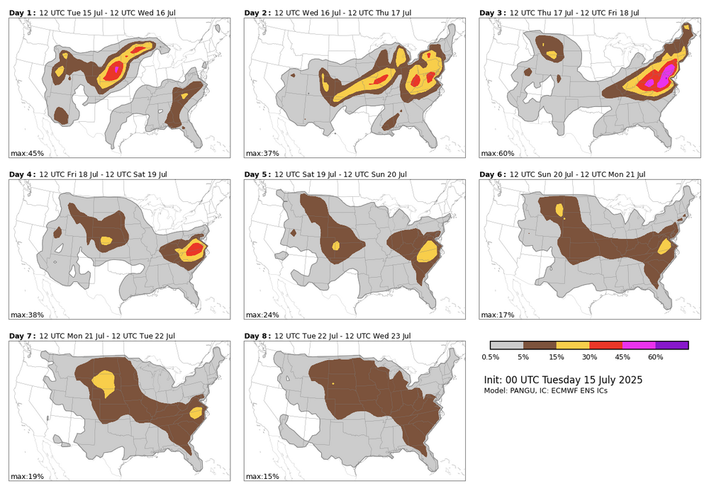
This is only one of the available algorithms. Note that they tend to be VERY robust so take with a grain of salt. I really only use it as a Day 4-8 "first guess" area to look for.
- 1,378 replies
-
- 1
-
-
- severe
- thunderstorms
- (and 2 more)
-
The NCAR AI severe page indicates a hefty chance of severe on Thursday - but SPC has held off on any risk areas due to the uncertainty from MCVs and prior day convection (and the position of the front). Bears watching.
- 1,378 replies
-
- 1
-
-
- severe
- thunderstorms
- (and 2 more)
-
Mother Nature is probably getting the ground nice and soggy and flood-prone in time for the Chesapeake-Potomac Hurricane of 2025.
-
Slow storm motions so far. Also sort of weak looking - definitely (at least so far) more of a heavy rain/flooding threat than a severe.
- 1,378 replies
-
- 2
-
-
- severe
- thunderstorms
- (and 2 more)
-
Related (but not directly to today) - has anyone using GR2AE or GR2 noticed lower resolutions? I've tried various color tables and while I might just be imagining things, it seems like the data is just blockier/lower resolution. I looked at the GR Owners forum and didn't on a cursory glance see anything. I am on the latest release (at least latest as of what I saw when I looked a week or so ago). Again - might be my imagination but it just "feels" way lower resolution than I am used to - even like as low as Level 3 data. This is coming through via my AllisonHouse subscription too...so presumably the data feed is not the issue.
-
The longer range 12z HRRR looked really solid....
- 1,378 replies
-
- 1
-
-
- severe
- thunderstorms
- (and 2 more)
-
Funny how sometimes we don't get a watch until there's a consolidating/existing line of storms well into the area. Other times there's hardly anything on radar except at the outskirts and we get a watch.
-
I guess this is good if it's accurate - maybe not so good if it's not so hot. I didn't see the HRRR referenced in that PDF - is that continuing?


