Kmlwx
-
Posts
13,616 -
Joined
-
Last visited
Content Type
Profiles
Blogs
Forums
American Weather
Media Demo
Store
Gallery
Everything posted by Kmlwx
-
 Yep. We probably needed a combo of this coming through during daylight, and also more breaks in the clouds during the day...and less crapvection. Perhaps any combo of two would have worked.
 -
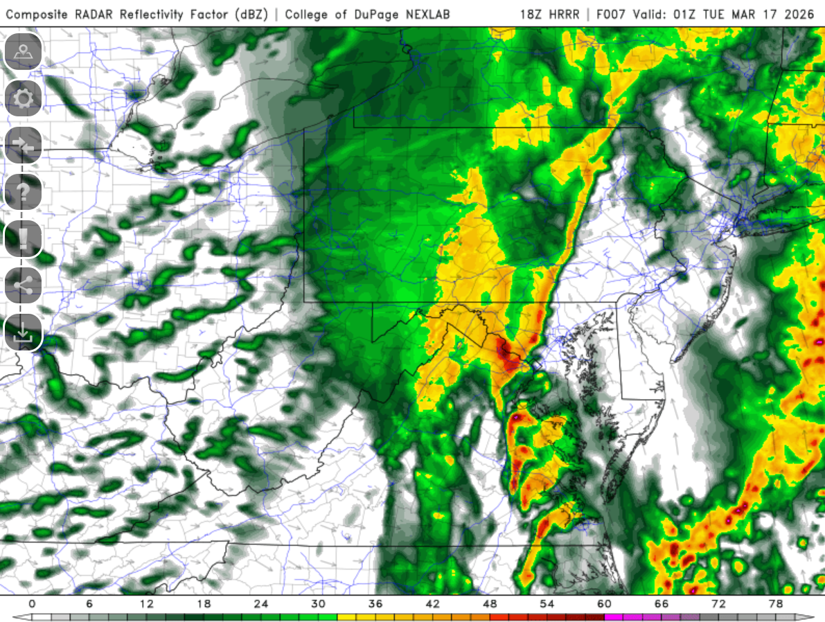
This shape of the line with a bend nearing DC/NoVa was well modeled by the HRRR
-
LWX velocity scans are picking up 40-50mph winds around and passing the radar site (under 500ft) heading east. Looks like they are broadbrush warning the entire line. Entire metro severe t'storm warning.
-
The biggest question will be how much of this will be able to mix down now that the sun is down.
-
Seeing some 60mph pixels down to like 2.5kft-ish W of Remington.
-
Velocities 3-5kft off the ground are impressive with the line coming near Culpeper now.
-
I also fought the separate thread for days. Finally gave into it...
-
Even for severe - making a thread results in a bust
- 1,093 replies
-
- 3
-

-
- severe
- thunderstorms
- (and 1 more)
-
59.4/59.4 at Colesville now. Off the high of 67.5
-
Close the thread
-
And another factor for any forced line later (or synoptic winds, for that matter) is that for areas that get a dumping of heavy rain - the soggy ground could make even sub-severe gusts capable of tree damage.
-
The latest HRRR (still rolling out now) still has a substantial forced line for later on - with a weird bend/kink in the line modeled right near the DC metro area. Wind gust product looks decent as well. Regardless of how stable we are - that line later will probably still pack a "punch" even if it's the sudden 50mph sub-severe variety.
- 1,093 replies
-
- 3
-

-
- severe
- thunderstorms
- (and 1 more)
-
Decent wall of rain and a bit of a wind gust just now in Colesville, MD as it hit.
- 1,093 replies
-
- 1
-
-
- severe
- thunderstorms
- (and 1 more)
-
This line has some "interesting" little cells in it. I am also curious to see how gusty the synoptic winds end up being after the frontal passage. That could add in a few more downed tree reports in the region (but not severe t'storm related, of course). I think there are a few interesting "kinks" in this line that bear watching for brief spin ups.
-
Yeah that looks decent - I must ahve been looking at the more recent runs.
-
Yeah could definitely see that. I think the big questions are how much recovery happens and how intense that frontal line gets. I could see it being anything from robust/gusty showers to a major damaging wind event. For now I'm holding back on sounding any alarms obviously. We will see what SPC thinks in the update coming soon. If they trim back probabilities for areas that have seen the line - we'll know their thinking we are "done"
-
None of the models seemed to have a great handle on that line that just went through. I want to see the next few HRRR runs to see if they change anything for later on.
- 1,093 replies
-
- 2
-
-

-
- severe
- thunderstorms
- (and 1 more)
-
Also - every now and then early shower/storm activity can enhance low level moisture and make things even soupier. Not that we had an issue with the warm air/dewpoint advection already - but with some sun on this moist ground that could really enhance things for later.
- 1,093 replies
-
- 1
-
-
- severe
- thunderstorms
- (and 1 more)
-
The other thing is that so far - these aren't doing the thing where a ton of stratiform rain develops behind storms and lingers for an hour or two. These seem to have plenty of clear areas on radar right behind the line.
- 1,093 replies
-
- 1
-
-
- severe
- thunderstorms
- (and 1 more)
-
I personally think this line is moving through early enough to allow for atmosphere recovery for afternoon activity. We'll see.
- 1,093 replies
-
- 4
-
-
- severe
- thunderstorms
- (and 1 more)
-
64 degrees with a similar dewpoint in Colesville, MD (but I'm at the office right now in Potomac)
-
One would think a new mesoscale discussion should be coming soon
- 1,093 replies
-
- 1
-
-
- severe
- thunderstorms
- (and 1 more)
-
To have YOU in our thread honking like this is alarming. Great analysis and we always welcome you in here with open arms.
- 1,093 replies
-
- 3
-

-
-
- severe
- thunderstorms
- (and 1 more)