-
Posts
13,434 -
Joined
-
Last visited
Content Type
Profiles
Blogs
Forums
American Weather
Media Demo
Store
Gallery
Everything posted by Kmlwx
-
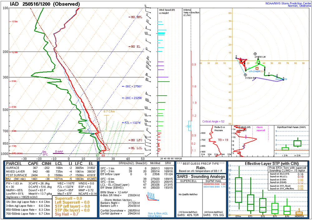
Sunshine? - Check Shear? - Present-ish CAPE? - Present-ish MLLR? - Nope. @Eskimo Joe - Thoughts?
- 1,378 replies
-
- severe
- thunderstorms
-
(and 2 more)
Tagged with:
-
On the CoD model page - many models showed decent clearing/sunshine this morning at least when I looked at them yesterday.
- 1,378 replies
-
- 1
-

-
- severe
- thunderstorms
-
(and 2 more)
Tagged with:
-
I'm mostly ready to "meh" this in MBY. Seems like one of those days when south of the area gets hammered, though.
- 1,378 replies
-
- severe
- thunderstorms
-
(and 2 more)
Tagged with:
-
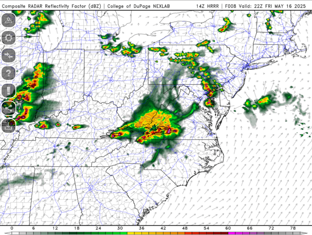
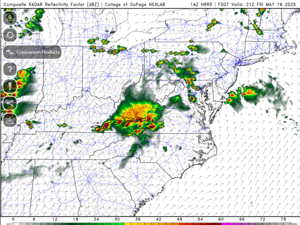
Sends a UH swath right through Charles County.....
- 1,378 replies
-
- severe
- thunderstorms
-
(and 2 more)
Tagged with:
-
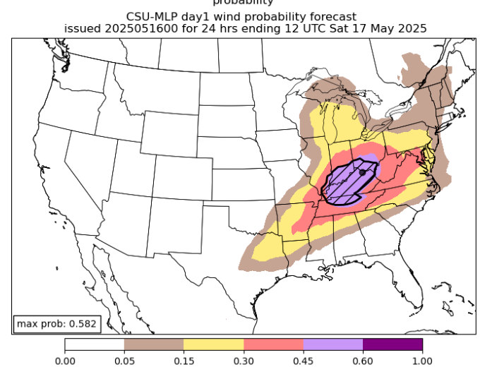
CSU doesn't like the threat...but CIPS is honking nicely.
- 1,378 replies
-
- severe
- thunderstorms
-
(and 2 more)
Tagged with:
-
It's been pretty uneventful this year in our area in the severe department. I might have to stop using the WxWatcher007 blanket....it might actually be a curse.
- 1,378 replies
-
- 3
-

-

-
- severe
- thunderstorms
-
(and 2 more)
Tagged with:
-
The 0z HRRR is pretty much a dud the rest of the night.
- 1,378 replies
-
- severe
- thunderstorms
-
(and 2 more)
Tagged with:
-
Mesoanalysis show a minimum of CAPE over most of the region. I just wonder if between the MLLR to the west potentially advecting in, and any "recovery" from any other processes overnight could sustain convection into our area. But judging my CAPE alone - it seems we are cooked for surface based activity. Perhaps the MLLR and better forcing and maybe if there's a cold pool fro the activity to the west could sustain covection. Lots of question marks.
- 1,378 replies
-
- severe
- thunderstorms
-
(and 2 more)
Tagged with:
-
Seems like a mixture of both.
- 1,378 replies
-
- 1
-

-
- severe
- thunderstorms
-
(and 2 more)
Tagged with:
-
HRRR fires storms in the 3am timeframe.
- 1,378 replies
-
- severe
- thunderstorms
-
(and 2 more)
Tagged with:
-
It honestly might miss MBY to the north - but yes it looks fierce!
- 1,378 replies
-
- severe
- thunderstorms
-
(and 2 more)
Tagged with:
-
Torrential rain with the MoCo cell that just went through. Nothing noteworthy otherwise. Thinking that if the next line holds up and doens't run out of gas it will be more intense.
- 1,378 replies
-
- severe
- thunderstorms
-
(and 2 more)
Tagged with:
-
The northern cell is still the more intense one it seems like. We'll see how this goes once they get some distance between each other.
- 1,378 replies
-
- severe
- thunderstorms
-
(and 2 more)
Tagged with:
-
Definitely not as intense but it definitely is a clean split now on radar!
- 1,378 replies
-
- severe
- thunderstorms
-
(and 2 more)
Tagged with:
-
The Loudoun cell looks like it might be splitting or bowing out.
- 1,378 replies
-
- severe
- thunderstorms
-
(and 2 more)
Tagged with:
-
I thought they might go higher on the hail in that MCD. Still seems like they are a bit uncertain about the ultimate outcome.
- 1,378 replies
-
- severe
- thunderstorms
-
(and 2 more)
Tagged with:
-
Clouds are moving in from the west. That could be a wrinkle to things...or it could provide a focus for activity perhaps.
- 1,378 replies
-
- severe
- thunderstorms
-
(and 2 more)
Tagged with:
-
No changes for our area on the 1630z SPC D1 outlook. I guess SPC still has big questions about initiation and coverage. The subsequent HRRR runs will be interesting to see if they keep that trend of convecting in that afternoon timeframe.
- 1,378 replies
-
- 1
-

-
- severe
- thunderstorms
-
(and 2 more)
Tagged with:
-
My gut feeling says no with so many funding cuts. But we are the DC area...so who knows. The more boundaries the merrier! Shows clear as day on LWX coming south.
- 1,378 replies
-
- severe
- thunderstorms
-
(and 2 more)
Tagged with:
-
It's definitely fueled up out there. Would be a good day for a special 18z sounding... Sitting at 84 degrees and dew of 74ish but I think it's running a bit high. It's been bouncing between 72 and 75 on my PWS.
- 1,378 replies
-
- severe
- thunderstorms
-
(and 2 more)
Tagged with:
-
- 1,378 replies
-
- 4
-

-
- severe
- thunderstorms
-
(and 2 more)
Tagged with:
-
- 1,378 replies
-
- severe
- thunderstorms
-
(and 2 more)
Tagged with:
-
Many of the CAMS really are not enthused about the overnight stuff locally - perhaps for southern portions of the area. That will be interesting to see if they are correct.
- 1,378 replies
-
- severe
- thunderstorms
-
(and 2 more)
Tagged with:
-
- 1,378 replies
-
- 3
-

-
- severe
- thunderstorms
-
(and 2 more)
Tagged with:
-
- 1,378 replies
-
- 2
-

-
- severe
- thunderstorms
-
(and 2 more)
Tagged with:


