anotherman
-
Posts
2,376 -
Joined
-
Last visited
Content Type
Profiles
Blogs
Forums
American Weather
Media Demo
Store
Gallery
Posts posted by anotherman
-
-

This could be a problem….-
 1
1
-
-
I remember it. Short but intense.
-
1
-
-
They do. I give my opinions in here too, mostly on the weather. I don’t find it necessarily off topic or “non weather related” to discuss the impact of terminating hundreds of very intelligent people in an agency that maintains/improves/provides weather forecasts and life saving warnings to all US and maritime interests, free and open access to computer modelling, analysis and data that all private weather entities (including free model sites) and weather enthusiasts like yourself use. All for an annual cost to the taxpayer that amounts to less than two months subscription to DT’s newsletter. But that’s just my opinion I suppose.
This. It is very related to what we talk about every day. -
2 minutes ago, paweather said:
This is a weather thread and only weather. People have their own opinions.
I simply posted the thread link to let everyone know. Also, Bubbler is there.
-
Just now, paweather said:
Get the F away from politics in this thread you can go elsewhere to post them jackass.
It's a different thread. Don't go there if you don't want to.
-
Just now, WmsptWx said:
Does everyone have a red banner about this or did I get flagged?
Everyone
-
3 minutes ago, paweather said:
Not in the one that matters.
Which one is that?
-
-
No wonder Bubbler left this forum after catching up from yesterday's post. Geezus people.
He’s in the political thread. -
16 minutes ago, Interstate said:
but always a chip on the shoulder... and always rubbed it in when he got snow on Parr Ridge and no one else did and how me moved their just for the snow.
I never felt that way.
-
2
-
 2
2
-
-
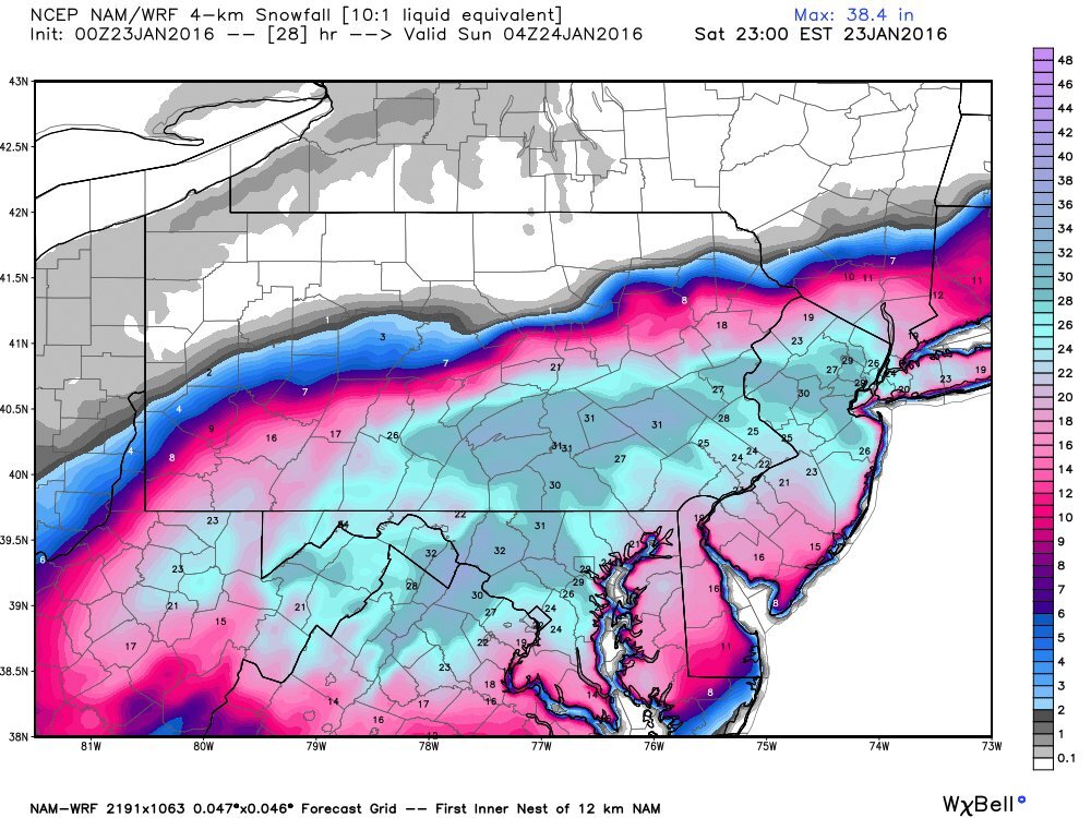
18z AI keeps it south.

-
 1
1
-
1
-
-
I think tomorrow whp-21 has a half hour special on the snow storm of 2003. I don't remember that one.
President’s Day? -
We need moisture badly. I don't even care if it snows.
-
4
-
-
yeah sorry not gonna happen it will be all rain or miss us all together

-
1
-
1
-
-
I’ve been outside since 8:00. The wind was awful all day.
-
1
-
-
Will be outside all day boiling maple sap into syrup. Please let the winds calm down.
-
5
-
-
4 minutes ago, Heisy said:
just depends if we get hurt by -PNA or not
-PNA
-
Have a friend in Virginia Beach. He reports at least 11 inches this morning.

-
With seasonal trends, we are likely done this winter. At least we got two events in.
Dude-
2
-
-
WWA for places just south of M/D line.
-
4 minutes ago, Itstrainingtime said:
A Day In the Life Of Central PA Weather: The 2025 Edition
Back by not-so-popular demand -
February 2025:
12:46AM: @Blizzard of 93 shares that the 0z Euro was a huge hit! He includes 7 maps. From one model run.
12:48AM: @Blizzard of 93 chastises the entire sub by asking out loud "where is everyone after this epic Euro run?" (I see it but choose to do normal things; like you know, sleep)
12:52AM: @Blizzard of 93 asks MAG what he thinks of the potential.
2:17AM: @MAG5035quotes @Blizzard of 93 and acknowledges the potential but isn't super enthused for the LSV. @Blizzard of 93 sees this and curses. Mrs. Blizz asks if he's cussing out @MAG5035 again...no answer
3:53AM: @Yardstickgozinya posts a nice picture from his backyard. There's text to go with it, I just don't understand it
4:09AM: @Voyager reports a current temp of 7.2. Says it's too damn cold and depressing. I agree with the depressing part. I wish it was -7.2
5:01AM: @Ruin says "weather models suck it was supposed to be 14 degrees but i have 13 and no wonder why people don't trust them because they are so inaccurate"
6:53AM: @mahantango#1posts his low overnight was 6.3. (okay, first off...what exactly is a "mahantango, and if since there is another member with the name "mahantango" shouldn't this guy be "mahantango2?"
7:04AM: @Bubbler86 posts that his overnight low was 8 and says that some in the LSV will hit 50 the next afternoon. I quick check my forecast and see a high of 36.
7:11AM: @anotherman posts his low was 11. I'm wondering who the other men are and how many are there?
7:17AM: @Ruin says "weather models suck it was supposed to be 14 degrees but i have 15 and no wonder why people don't trust them because they are so inaccurate"
7:22AM: @pasnownut gives a PBP of his car temperature for every little nook and cranny between Akron and Elizabethtown. Never once mentions what his low temp was at home
7:27AM: @sauss06 states that at his age it's too damn cold anymore. Hmmm.
7:42AM: @Superstorm says the pattern looks ripe over the coming week. I utter "congrats, Short Pump"
7:43AM: @canderson starts talking about the next wind event that's coming in 11 days. Before that we have 3 storms to deal with, but he overlooks them
7:52AM: @pawatch shares a beautiful picture from up north. I remind myself that it's time for a trip up Rt. 44 soon.
8:17AM: @Mount Joy Snowman shares the nation's high and low temp for the previous day and includes a comment that no one really cares ha. One, I care, and have said as much on multiple occasions. B, if you don't think anyone cares, why in the hell are you sharing it?
8:22AM: @Bubbler86 changes his avatar picture to reflect the team he follows that won the previous night
8:53AM: @CarlislePaWx gives a lengthy synopsis of his temp, dew point, snow cover, precise rate of snow melt, sun angle, and then I stop reading
9:28AM: @Festus informs us that we've gained 65 minutes of daylight since December. Cool.
9:37AM: @Bubbler86mentions that the NAM is showing 1" of snow today over Lanco. I spit out my coffee
9:45AM: @pasnownut says that while parsing the overnight runs, his tellies suggest some fun in store over the next 2 weeks. And? My wife and I had fun one night last August. Big freaking deal.
10:27AM: @Bubbler86 reports the ICON has 3" over Lanco today. At this point I realize that IKEA is more accurate in weather forecasting than ICON.
10:45AM: @paweather quotes @Bubbler86 post about 50 degree temps and says "I guess we'll hear from TCC today" (meanwhile, "TCC" is posting about snow in Pittsburgh)
11:17AM: @Bubbler86 posts a random GFS image showing snow over the entire LSV. I check the time stamp and it's 1252 hours out
11:18AM: @Ruin quotes @Bubbler86 post and says ""weather models suck it was supposed to be 14 degrees but i have 25 and no wonder why people don't trust them because they are so inaccurate"
11:37AM: while perusing the MA forum I notice that @Blizzard of 93 graced our southern neighbors with his presence in their long range thread and hoisted 26 snow maps overnight and received 33 weenies in response
12:24PM: @Mount Joy Snowman has calculated that the month will end 2.548725 degrees below normal. Ballsy call, I say considering it's February 3rd
12:53PM: @WmsptWx says that it's snowing so hard that his road caved. I pause, and begin processing - is this in Clearfield County or Lycoming County...?
1:01PM: @Blizzard of 93 stops in over lunch to share a post that PSU Hoffman made in the MA thread about snow coming
1:12PM: @AccuChris posts the latest Euro snow map through the end of the run. There's nothing on it in the LSV
1:28PM: PSU Hoffman admits he had the setup wrong and now admits that he's out on upcoming snow chances. For whatever reason, @Blizzard of 93 fails to share this post
1:41PM: @GrandmasterB says the EPS is much better than the Operational run. I begin singing "Love and Marriage" for the next 4 hours
1:43PM: @Ruinsays "weather models suck it was supposed to be 14 degrees but i have 31 and no wonder why people don't trust them because they are so inaccurate"
2:16PM: @canderson says that he feels like winter is done. This comment is to the surprise of no one in our thread.
2:42PM: @Caveman reports a current show depth of 5.3". Is this guy the "Captain Caveman" from TV and if so, what happened to the Teen Angels?...
3:44PM: @Bubbler86 posts a NAM snow map showing 11" of snow over Lanco for the next day. I'm wondering how that's possible given Bubbler's prediction of 50 degree weather
4:04PM: @DDweatherman reports a current snow depth of 4" in Carroll Valley. I check out the Liberty webcams and see green grass surrounding the slopes. He's got one hell of a microclimate
5:12PM: @Bubbler86 shares the GFS's depiction of a major snowstorm at hour 210 for all of PA
5:13PM: @Ruin says "I'll believe it when I see it weather models suck it was supposed to be 14 degrees but i have 33 and no wonder why people don't trust them because they are so inaccurate"
6:25PM: I get excited when I open our thread after supper and see both the "Hot" tag and that we've advanced 2 pages over the past hour...
6:20PM: @Blizzard of 93begins an onslaught of model runs, snow maps and weeklies and announces that "he'll be using that snow blower a lot over the next 2 weeks" (little does he know at the time, the snow blower never actually moved)
6:28PM: @Blizzard of 93 asks @MAG5035 for his thoughts. Crickets.
7:07PM: @Storm Clouds says that we can't catch a break, bring on severe storms! Dude...that time will come in a few months...
7:32PM: @canderson reports a wind gust of 33 mph. I go outside and there's not a trace of a breeze blowing
7:52PM: @Jns2183 makes a string of statistics posts. @Mount Joy Snowman is salivating upon seeing this
9:29PM: @Bubbler86 said that the 0z NAM took away all 11" of snow over Lanco. In fact, the nearest snow on the NAM is in Cleveland.
10:08PM: @MAG5035 makes a detailed post with his thoughts on the upcoming pattern. And while he acknowledges that the pattern might be conducive for snow in Ohio, New York, New Jersey, Delaware, Maryland, Virginia, West Virginia and all of western PA, he's not onboard for snow in central and eastern PA. @Blizzard of 93 says to himself "I'll never ask him for this thoughts again!"
11:11PM: @Blizzard of 93 shares the GFS snow map through the following week. There's a tiny sliver of blue over the Finger Lakes. Blizz says that it's close enough for us to track...
11"47PM: I laugh at @Blizzard of 93 all while appreciating him for who he is - just a rabid snow freak like so many of us in here. What a great place to be surrounded by some really cool people. As @Mount Joy Snowman would say -
"Onward"
My username is taken from a Pearl Jam song called "Sleight of Hand."
-
1
-
 1
1
-
-
The AI is becoming the new Dr. No.
-
 1
1
-
-
8 minutes ago, Itstrainingtime said:
Same here. Invigorating!
Especially with shorts on.
-
1
-
-
GEFS is bringing the tpv farther S run after run
By 180 hours
.
Another New Orleans snowstorm?

Central PA Winter 2024/2025
in Upstate New York/Pennsylvania
Posted
Thunder!