All Activity
- Past hour
-

July 2025 Obs/Disco ... possible historic month for heat
kdxken replied to Typhoon Tip's topic in New England
Headed to Connecticut to play golf. Always sunny and hot there according to some. -
July 2025 Obs/Disco ... possible historic month for heat
kdxken replied to Typhoon Tip's topic in New England
Wow I don't think I've ever heard of anybody getting all three at once. That's scary. anaplasmosis is nothing to mess around with. Must be a tough guy to go a few weeks with it. -
July 2025 Obs/Disco ... possible historic month for heat
kdxken replied to Typhoon Tip's topic in New England
Right? And it comes at the hottest time of the year. You hate to see it. Maybe we can squeak above normal today after the recent cold snap.
-

July 2025 Obs/Disco ... possible historic month for heat
HoarfrostHubb replied to Typhoon Tip's topic in New England
I’m ok with warmth, even humidity in summer months (to a point), but mornings like this are gross. Should be better later on. -

July 2025 Obs/Disco ... possible historic month for heat
CoastalWx replied to Typhoon Tip's topic in New England
Dew is 65. Not bad out. But yeah these murky mornings suck. -

Occasional Thoughts on Climate Change
donsutherland1 replied to donsutherland1's topic in Climate Change
That's why one should refer to the literature rather than social media tweets or opinion pieces from individuals who are not only outside the field, but working for organizations with interests that run counter to the science. The Martz op-ed provided earlier in this thread offers a classic example of the flaws inherent in doing so. His primary interest was to claim that climate change is not leading to an increase in extreme rainfall events. He never appropriately addressed the actual question. The piece is deeply flawed, ranging from lack of transparency to bad methodology. Six issues: 1. The piece revealed unfamiliarity with the literature, both papers and attribution studies. In fact, no literature was referenced. 2. The piece showed an absence of basic physical knowledge, namely when it comes to application of the Clausius-Clapeyron Equation that shows a direct relationship between increased temperature and increased capacity of the atmosphere to hold water vapor (approximately a 7% increase in water vapor capacity for every 1°C increase in temperatures). 3. Lack of awareness of recent very high Precipitable Water (PWAT) values in areas hit by excessive rainfalls (as would be predicted by the C-C equation). 4. Overgeneralization: He took 21 COOPs (unnamed) and suggested that they represent all of Texas. A more nuanced and specific description was needed. 5. The failure to name the COOPs deprives the exercise of transparency and makes reproducibility impossible. 6. Use of highest daily rainfall each year and reference to "unprecedented" events: An ability to identify the appropriate information for addressing research questions e.g., whether extreme rainfall events have increased, is essential to addressing those questions. There was a mismatch between what he looked at and the question involved. Extreme rainfall events are not equally distributed each year. Some years have clusters of such events. Others have none. The Martz approach gave all years equal weight and excluded numerous extreme rainfall events. His approach produced no useful information for addressing the question. These flaws are fatal. If one is seeking to contradict the literature, the evidence needs to be particularly strong and specific to the research question(s) involved. To be credible, the findings need to be reproducible, therefore, transparency of methods is of paramount importance. -

July 2025 Discussion-OBS - seasonable summer variability
Sundog replied to wdrag's topic in New York City Metro
I think many times people in the US have a level of self centered-ness. The USA is only responsible for like 10% of global emissions. The US can be completely greenhouse gas neutral tomorrow and the problem would have barely changed. A billion people still go to the bathroom in the fields, a few billion more don't have clean water to drink. They're not interested in nor care about climate change. -

July 2025 Obs/Disco ... possible historic month for heat
Hoth replied to Typhoon Tip's topic in New England
Just putting out a general service announcement to check yourselves regularly for ticks. My dad has been having flu-like symptoms on and off for a couple weeks and just came back positive for Lyme, erlichiosis and anaplasmosis. Heavy heavy doxycycline in the forecast. He hasn't developed an allergy to red meat though, so there's the silver lining. -

July 2025 Obs/Disco ... possible historic month for heat
Damage In Tolland replied to Typhoon Tip's topic in New England
This is the best feeling. Summers like this where it’s humid literally every single day. With no breaks as far out as one can see . You don’t have to worry about being cold or bringing/ wearing a hoodie at night or in the morning, Just shorts, tees, lots of summer activities and vibes. Enjoying cold IPA’s on the deck or tracking storms. Life slows down and the high dews are a huge factor in making people happy. - Today
-
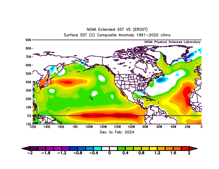
That’s the composite for the old days. Our new El Nino back in 23-24 had the mid-latitude marine heatwaves from Japan across the Atlantic to near Spain. So it resulted in a record warm pattern for North America even though the ONI was much weaker than 15-16 and 97-98.
-

July 2025 Discussion-OBS - seasonable summer variability
bluewave replied to wdrag's topic in New York City Metro
While our summers here have become much warmer since 2010, at least they aren’t warming at the rate that Western Europe is. -
July 2025 Obs/Disco ... possible historic month for heat
HoarfrostHubb replied to Typhoon Tip's topic in New England
These manky mornings are getting old. The stale air and clouds… -

July 2025 Obs/Disco ... possible historic month for heat
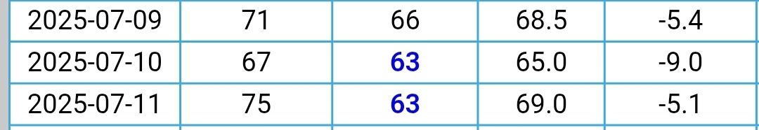
dendrite replied to Typhoon Tip's topic in New England
Min 67° Cold! -
This is a good recent review article. Anthropogenic intensification of short-duration rainfall extremes https://hal.inrae.fr/hal-03838107v1/file/2021_Fowler_Nature reviews earth%26environment.pdf
-

July 2025 Discussion-OBS - seasonable summer variability
nycwinter replied to wdrag's topic in New York City Metro
back in the 1970's and early 1980's or even earlier the us had deadly heat waves that killed hundreds before widespread ac became common.. europeans will have to become use to getting ac.. -
July 2025 Discussion-OBS - seasonable summer variability
nycwinter replied to wdrag's topic in New York City Metro
you find high dewpoints beautiful whatever floats your boat... -

July 2025 Discussion-OBS - seasonable summer variability
SACRUS replied to wdrag's topic in New York City Metro
Highs: PHL: 90 TEB: 88 TTN: 88 EWR: 87 New Brnswck: 86 LGA: 85 NYC: 84 ACY: 84 JFK: 82 BLM: 80 ISP: 79 -
Up to 1.83" for the day. Best soaker of the year so far. Combined with yesterday's 0.27" brings us up over 2 inches for the 2-day.
-
Sitting on my front porch can see a nice lightning display and hear some faint thunder from another flash flood warned storm across Afton in Nelson County near or just east of the Wintergreen area....
-
Im beginning to believe that my backyard and yours cannot both do well in the same time period during thunderstorm season... I've already matched June down here so far in July... Most of my June rainfall came in two individual thunderstorms...
-
Less than 1/2" of rain since Jun 28.
-

2025 Short Range Severe Weather Discussion
HillsdaleMIWeather replied to Chicago Storm's topic in Lakes/Ohio Valley
Chicago Storm wins again -
This isn’t that complicated. It’s getting warmer. And no I don’t care if you can’t handle that fact emotionally. Either because you love snow so much or because you’ve tied your identity to rejecting facts that are inconvenient to your preferences. The thermometer DGAF about your feelings. Regression studies of snowfall are somewhat flawed imo because they apply increased temps to historical storms. Storms tracks depend on thermal boundaries so warmer temps mean the storms aren’t even in the same places anymore. But let’s simplify this. If it’s warmer in general meaning on the average storm tracks will shift north…well that means less snow for us because as you go south from here at similar elevations snowfall goes down. It’s that simple. The climate zones are shifting north with the temps. So what was once normal snow for somewhere in south or Central VA 30 years ago is now DC. Yes there will continue to be snowier and less snowy cycles and winters and there will be occasional big storms but the larger trend is really clear.
-

July 2025 Obs/Disco ... possible historic month for heat
Torch Tiger replied to Typhoon Tip's topic in New England
unnfff -
July 2025 Obs/Disco ... possible historic month for heat
Torch Tiger replied to Typhoon Tip's topic in New England