All Activity
- Past hour
-
93 here with heat index of 103 If we can sneak out another 90 tomorrow that will make heatwave #2 for me Heavy t storms look to scrape my area
-
Hopefully tonight we get some action. It looks like NAM brings in the action late evening. My area is getting swampy but the storms are fun lol
-
BUST
-
Where did your tee shot go on the par 3 pictured?
-
I'm in the low 90s. I thought it was supposed to be like 87 today?
-
Delayed but not denied
-
Continue to miss the cells, they develop a mile from me and then move NE and get stronger Some new activity forming just North of Baltimore currently.
-
Those clouds today hurt the usual spots from hitting 93-94. BDL still pulled off 90. There were times when it was almost complete cloudy for 15 minutes
-
92 here
-

E PA/NJ/DE Summer 2025 Obs/Discussion
JTA66 replied to Hurricane Agnes's topic in Philadelphia Region
Plenty of thunder and some wind, but nothing more than passing drizzle. Still, it was enough to knock my temp down to 81F. -
Close here at 88F currently.
-
Just hit 90 here
-

E PA/NJ/DE Summer 2025 Obs/Discussion
pl0k00n111 replied to Hurricane Agnes's topic in Philadelphia Region
Northeast philadelphia at my work. The gusts were very strong! Some hail and heavy sideways rain. It lasted a good 10 minutes before it passed. -

Central PA Summer 2025
Mount Joy Snowman replied to Voyager's topic in Upstate New York/Pennsylvania
A couple brief downpours here over the past couple of hours helped to temporarily knock back the heat. -
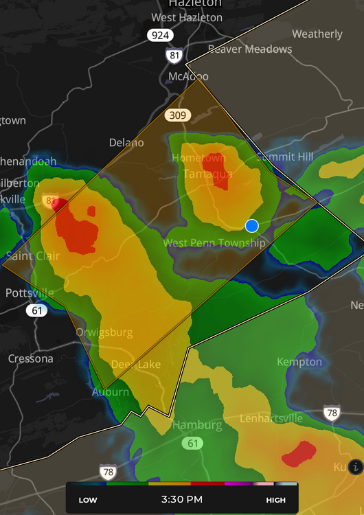
Finally got one in Tamaqua, but I'm sitting in the eye doctor's chair where the blue dot is...
-

E PA/NJ/DE Summer 2025 Obs/Discussion
Hurricane Agnes replied to Hurricane Agnes's topic in Philadelphia Region
Rain tapering now. Was up to 1.63"/hr at one point and currently have 0.44" in the bucket. Temp got knocked down almost 20 degrees from my high of 94 today and it's currently raining lightly with temp of 73 and dp 73. With the dribs and drabs for June, I ended up with 3.62" for the month (so far). -
Installed a station today. It was far worse outside than last week.
- 1,222 replies
-
- 1
-

-
- severe
- thunderstorms
- (and 2 more)
-
It is but 12z 3k NAM is still matching very well
-
lots of rain in the spring but nothing like the hailers or microbursts of yore. I can't tell you how many times we got caught on boats as kids. No phones no radar, fishing offshore and by the time you saw cloud tops it was too late.
-
ewr hit 93 behind the seabreeze lol
-
it’s the 3rd or 4th consecutive day of afternoon thunder, but maybe we’ll get some decent rain today for a change. 88 for the high today.
-
Well, I'm warned for the one south of Pottsville that popped up. We'll see what comes of it.
-
District of Columbia-Frederick MD-Carroll-Northern Baltimore- Southern Baltimore-Prince Georges-Anne Arundel-Northwest Montgomery-Central and Southeast Montgomery-Northwest Howard- Central and Southeast Howard-Fairfax-Arlington/Falls Church/Alexandria-Eastern Loudoun- 307 PM EDT Mon Jun 30 2025 ...FLOOD WATCH IN EFFECT UNTIL 11 PM EDT THIS EVENING... * WHAT...Flooding caused by excessive rainfall is possible. * WHERE...Portions of DC, including the following , District of Columbia, Maryland, including the following areas, Anne Arundel, Carroll, Central and Southeast Howard, Central and Southeast Montgomery, Frederick MD, Northern Baltimore, Northwest Howard, Northwest Montgomery, Prince Georges and Southern Baltimore, and northern Virginia, including the following areas, Arlington/Falls Church/Alexandria, Eastern Loudoun and Fairfax. * WHEN...Until 11 PM EDT this evening. * IMPACTS...Excessive runoff may result in flooding of rivers, creeks, streams, and other low-lying and flood-prone locations. * ADDITIONAL DETAILS... - Thunderstorms are expected to develop in the next couple of hours across parts of the Baltimore and Washington metro areas. Storms are expected to be slow movers and be capable of producing intense rainfall rates of 1 to 2 inches per hour, which may result in flash flooding of small streams, creeks, urban and poor drainage areas.
-
International shipping (which was a major source of aerosol pollution) also became much cleaner like in 2020 or something like that. Tack that on top of the rising temps too.
- Today
-
Radar is a real sleeper. Looks like we get a break today.


