All Activity
- Past hour
-

July 2025 Discussion-OBS - seasonable summer variability
steve392 replied to wdrag's topic in New York City Metro
Just uncomfortable out. -

July 2025 Obs/Disco ... possible historic month for heat
40/70 Benchmark replied to Typhoon Tip's topic in New England
It's usually time to draw the shades and hide in the AC if you hate dews from now until about first week or two of September.....this next two months are usually office, save for a rogue pleasant day or three- -

July 2025 Obs/Disco ... possible historic month for heat
RUNNAWAYICEBERG replied to Typhoon Tip's topic in New England
It would be wolfie’s lifetime achievement if he could be one of the cops there. -

July 2025 Discussion-OBS - seasonable summer variability
SACRUS replied to wdrag's topic in New York City Metro
82 / 71 partly cloudy - sun poking through. Warm/humid the next few days mostly 80s- hotter inland spots away from sea breeze may make it to 90 Scattered storms Sun late and more Monday. Hot/humid week ahead and overall hotter into the beyond. 7/12 - 7/14: Warm / humid storms rain focus in Monday 7/15 - 7/18 : Hotter / humid. 7/19 - Beyond : Hot / humid wetter overall -

July 2025 Discussion-OBS - seasonable summer variability
forkyfork replied to wdrag's topic in New York City Metro

-

July 2025 Obs/Disco ... possible historic month for heat
Sey-Mour Snow replied to Typhoon Tip's topic in New England
-
Boy it’s gross out
-
July 2025 Discussion-OBS - seasonable summer variability
forkyfork replied to wdrag's topic in New York City Metro
societal breakdown is the only way climate change will be stopped -

July 2025 Obs/Disco ... possible historic month for heat
CoastalWx replied to Typhoon Tip's topic in New England
Nice and sunny now -

July 2025 Obs/Disco ... possible historic month for heat
kdxken replied to Typhoon Tip's topic in New England
No sign of Stein in Connecticut.
-

July 2025 Discussion-OBS - seasonable summer variability
SnoSki14 replied to wdrag's topic in New York City Metro
What's truly mind-blowing is that in only 50 years temperatures have increased by that much whereas they've been mostly stable for 10s of 1000s of years prior to that. -

July 2025 Obs/Disco ... possible historic month for heat
bristolri_wx replied to Typhoon Tip's topic in New England
-
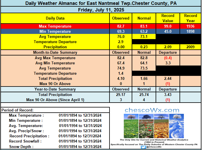
Partly sunny today and continued warm and muggy with temperatures today and the rest of the week mainly in the mid to upper 80's. Some of the lower and warmer spots may touch 90 degrees today and again on Tuesday. Higher ridge locales are likely to get no higher than the upper 80's. Shower chances ramp up yet again by Sunday night into Monday. Rain chances lessen much of the work week before increasing again by Friday.

-

E PA/NJ/DE Summer 2025 Obs/Discussion
ChescoWx replied to Hurricane Agnes's topic in Philadelphia Region
Partly sunny today and continued warm and muggy with temperatures today and the rest of the week mainly in the mid to upper 80's. Some of the lower and warmer spots may touch 90 degrees today and again on Tuesday. Higher ridge locales are likely to get no higher than the upper 80's. Shower chances ramp up yet again by Sunday night into Monday. Rain chances lessen much of the work week before increasing again by Friday.
-

July 2025 Obs/Disco ... possible historic month for heat
HoarfrostHubb replied to Typhoon Tip's topic in New England
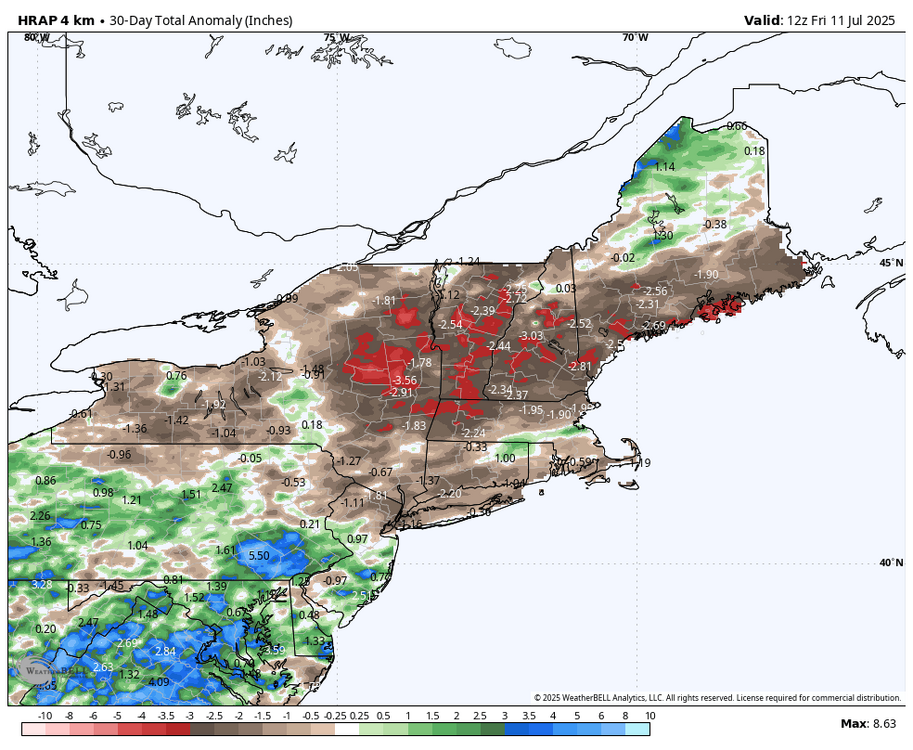
Rains in Maines -

July 2025 Obs/Disco ... possible historic month for heat
Damage In Tolland replied to Typhoon Tip's topic in New England
https://x.com/bennollweather/status/1944030233297842337?s=46&t=dhcbvkjmRcyBVQtDxJ3lRg -

July 2025 Obs/Disco ... possible historic month for heat
dryslot replied to Typhoon Tip's topic in New England
Best storm of the season, Frequent lightning, Thunder and no warning. -

July 2025 Discussion-OBS - seasonable summer variability
nycwinter replied to wdrag's topic in New York City Metro
i thought the amoc was slowing down if that continues and it stops would that not mean a colder europe in the future? - Today
-
July 2025 Obs/Disco ... possible historic month for heat
dryslot replied to Typhoon Tip's topic in New England
Dumping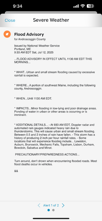
-

2025 Atlantic Hurricane Season
BarryStantonGBP replied to BarryStantonGBP's topic in Tropical Headquarters
-
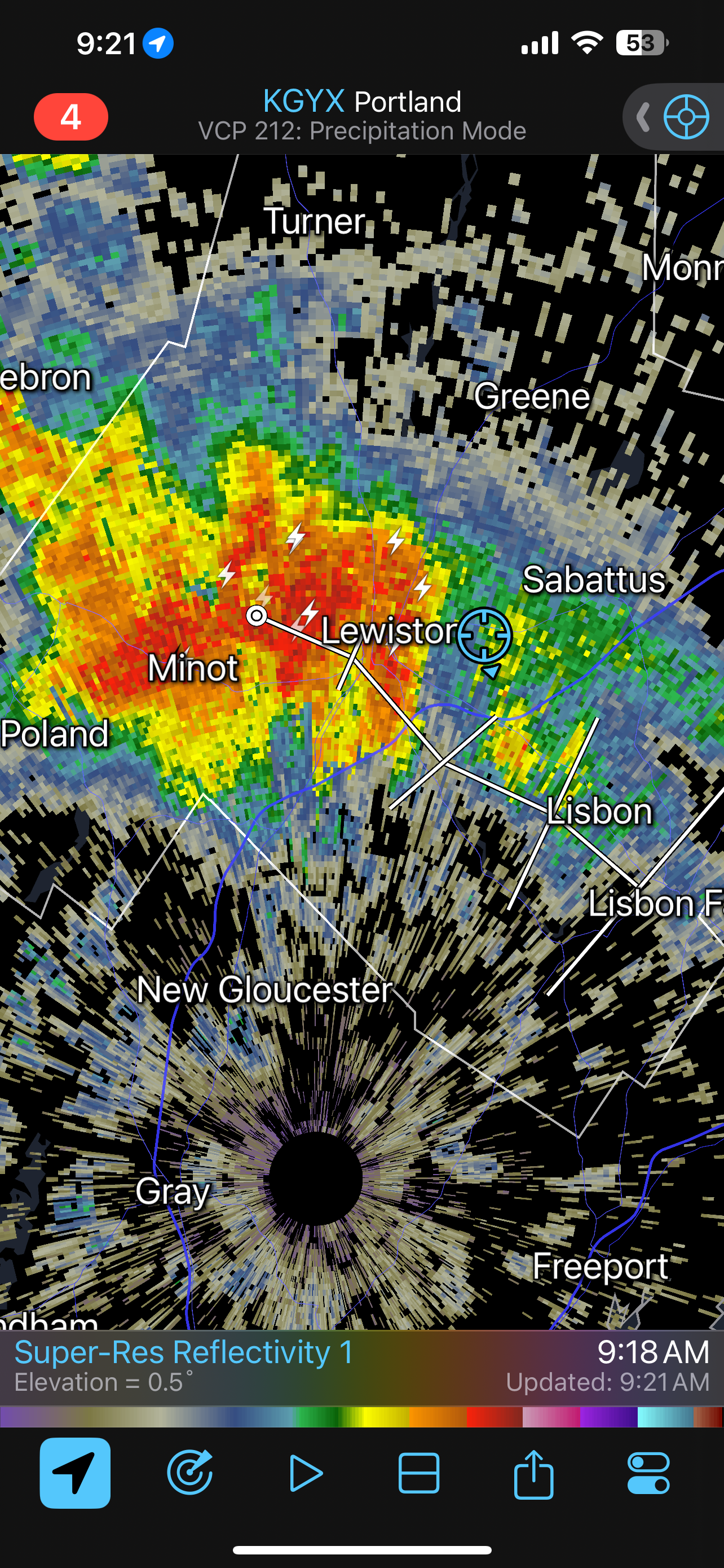
July 2025 Obs/Disco ... possible historic month for heat
dryslot replied to Typhoon Tip's topic in New England
The only cell around and its overhead, Another crappy Saturday.
-

July 2025 Obs/Disco ... possible historic month for heat
weatherwiz replied to Typhoon Tip's topic in New England
Dewpoint is 81F in Key West…beautiful -
Your rain shadow is a tough one for typical east-moving t-storms. You need a decaying tropical system with NW moving rain bands
-
Happy Belated, @WxWatcher007!!! I would ask how old you are, but we all know the Reaper is AGELESS!!
-

July 2025 Obs/Disco ... possible historic month for heat
tamarack replied to Typhoon Tip's topic in New England
Had anaplasmosis in November 2022, wife thought I was having a stroke, vision was messed up, 10 days of doxy did its work. Not trying to lower the danger, but I've found that ticks seem less prevalent here during the 2nd half of met summer. Whether they estivate then to avoid the heat, or some other phenomenon, they seem to disappear then. In mid-August 2019 our annual 2-day forest excursion was in southern Maine - Swan Island (huge deer population), Newcastle, Hebron (near LEW) and Skowhegan. 40+ people, not a single tick reported. 10 weeks later I picked up 26 deer ticks in a half-day visit to a state lot in Topsham, 6 miles south from Swan Island.