All Activity
- Past hour
-
Yes, you can get mid-level eyes appear even in the TD stage. In this case, since there is no deep convection over the center, it is lower-level feature w/ shallow convection around it that makes it look like an eye. Look at the platform obs to the SW. NE winds? Talk about a small circulation! The small TC for rapid intensity changes is tricky. A small TC is more sensitive to dry air intrusions or shear than a larger one, but at the same time, having a small RMW promotes RI easier. Mesoscale factors in the inner core come into play, and are very tough to fcst. Recall HU Oscar a few years ago? That had one of the smallest RMW for a Atlantic HU on record and models had no clue!
-
The tar spots are just ugly. I feel like a lot of trees last year were not able to be brilliant orange, red, or yellow last fall, because there was so much black coloring on each leaf. I believe the red maple (sugar maple?) small trees in my neighborhood have almost none of this problem.
-
small feature that looks like an eye, but of course a true eye should come with a hurricane
-
 mexican pharmacy near me: the purple pharmacy mexico - mexican farmacia
 -
canadian pharmacy store: my canadian pharmacy review or best canadian online pharmacy reviews
-
Yea, pretty generous for a super nino. I'd be estatic if that occurred.
-
Yes and the newest run continues with the AN precip anomalies up and down the east coast.
-
https://www.youtube.com/watch?v=2i4xnjcMme0
-

2026-2027 Record-breaking El Nino
Jebman replied to Stormchaserchuck1's topic in Weather Forecasting and Discussion
This is primarily the reason I now expect normal precipitation for Austin thru September in 2027. For this autumn and winter, maybe a couple of inches, and some drizzle. All of my hopes for at least replenishing rains in Austin are utterly DASHED. Texas WILL run out of water. We will run out of the water because of a catastrophically dry Record El Nino, then we get a catastrophically strong Nina. That strong Nina, in 2027 or in 2028, is why Texas will break so many high temperature records and get so damned DRY that the groundwaters WILL run out and the Colorado River will get lower than anyone in living memory can ever recall. At the same time, the tech buildup in Austin will cause many many many people to move here accelerating the water uptake with nothing to replenish the water reserves. By 2029 water will be so expensive many will move east into the mid South where there is much more rain. There is a reason all the trees down here are a third of the height of trees in N Virginia. It's dry. We are so forsaken by life-giving rains, that even during the 40 day rain event of deep antiquity, we probably got 40 days of light drizzle. We are used to this. It is NO surprise. Of course we got missed by the strongest El Nino in history! I have always wanted to be caught right in the middle of a record 489 billion year flood for the Ages. Of course, I am shyte out of luck and always will be. This is a very east-based Nino, moisture plume will orient very far east,(well-away from south central Texas of course) record Nino or not. If you like sunshine, no floods ever, and east based Ninos, come live in Austin. We will have plenty of sun all winter and the average high temperature in January in Austin is 60 degrees! We have the best weather in the entire world, especially if you don't mind perpetual drought and rapidly diminishing water reserves! Damn I have got to get out of this place! I wanna spend a few years in Cherrapunji, India. Trust me, that place gets plenty of rain! Nepal stole our flood event. Damn! -
Using a web hosting site like Imgur would help. You would upload there and just post the image links in one post here. I’d roll the dice with that temperature outlook all day, as long as we get plenty of systems passing through.
- Today
-
Hey at least it's a chasable track now. 82 between Port Arthur and Holly Beach has a couple of bridges to take refuge on with a weaker storm like this when surge comes in. Of course they are teasing you with the hurricane watch not to mention recon with the 'eyewall beginning to form.
-
IMHO, I think they are really pushing the limit for HU watch here. Yes, the pressure is down, but the convective area waned considerably at the time until about an hor ago, yet NHC did not even acknowledge this clear cycle down on sat? Again, I think they tend to not include if they can anything that show weaker or a struggle, but as posts noted on the thread in the last few hours, Edouard looks not so good (skeletal). So I am just speaking out loud here what others might be thinking as well and not thinking in an isolated vacuum! Yes, the risk is there, but err'ing on the side of caution I find influence more by social pressure rather than sticking to the met science these days, which has advanced big time over the decades. And, yes, I am aware of what HU Humberto did in Sep 2007 in the very same area, but that was an exceptional event, no other like that on record, so that alone is not enough. Also objectively, current environmental conditions concerning dry air are a sig problem as evidenced by the wane of convection earlier and what we see just to the N on the mid-level WV, so that would count against such aggressive RI. All I am saying is that the door swings both ways here, so in Edouard's case given the factors, IMHO would be more logical/practical to split it down the middle (steady but more modest straightening). rather than chose any one clear direction until we actually see evidence of RI. esp on satellite/radar and it being in a data rich area. It's not like we will be in the dark as to trends hour-by-hour. Lots of platform sfc obs off the LA coast, as one example. I know I am verbose and sound pedantic, but it shows how there is a *lot* to consider in TC forecasting, and forecasting in general. How one chose to go in any given situation is subjective of course. My position is that I do not go high aggressive in a forecast until I see clear reason to do so ((in other words, not forecast an outlier, rare, or exceptional event unless it is clear it has a good chance of occuring), and the amount of wx data and its detail these days, one can afford to "wait and see" more IMHO.
-

Septorcher 2026 Discussion - Endless Summer
CT Valley Snowman replied to Damage In Tolland's topic in New England
Well facts are facts. Without today's final calculations, BDL+ 0.8, ORH +1.6 BOS +2.6. Obviously BDL radiated certain nights and BOS night urban heat island probably the biggest difference between the two. BDL 4 days 90+, BOS 3, ORH 0. No 90 degree days after the 10th of the month. Dews were above normal, but not exceptional. It was a boring uneventful month here. Nothing exciting, no big storms, no canes, and the 4-day heat wave was nice but not extraordinary, the highest temp was 92. Rainfall was above average here, but nothing compared to areas SW. ORH and BOS were drier. Logan only had 0.98. It was almost a lock to end up with above normal temps, but it was not really a noteworthy torch around here. Just a typical warm boring summer month. Hopefully September brings some more excitement. -
https://mexiph.com/# mexico medicine
-

2026 Mid-Atlantic Severe Storm General Discussion
high risk replied to Kmlwx's topic in Mid Atlantic
I'd say that there isn't much doubt about it, especially in the East. We've had several derechos over the year die an ugly death over the mountains to our west when no EML was in place downstream. One event in 2000 led SPC to issue a rare PDS severe thunderstorm watch here due to an intense bow echo over southeast Ohio blasting east. Our environment did not have an EML, and the Appalachians shredded the system - we ended up with line of showers featuring gusts to 30 kt. -

2026-2027 Record-breaking El Nino
MJO812 replied to Stormchaserchuck1's topic in Weather Forecasting and Discussion
Beautiful signature. Should be a fun winter . Very active ( Hopefully alot of snow) -
Some get *far* to impressed w/ large MCS areas w/ very cold cold tops for nascent TCs. Yes it is intense convection, but that does not correlate well when it blows up very fast b/c that often mean it will dissipate just as fast. And the collapsing convection hinders organization at low-levels, .It can also happen when a system of mdt TS status. You get this immense area of very cold cloud tops, sometimes below -100 C, in a rather symmetric blob, calked a CCC, but there is no banding. When this happens, the TC often is stunted in intensification until the CCC feature goes away. If Edouard has a blow up of convection overnight, watch closely, Does it form in a coherent band as we are seeing on the N side now, or is is just random blobs (zits!) expanding radially? Also, you can have a combo of this. Banding now on the N side is good, but nothing on the S side, This implies dry air wrapping in. Also, the banding on the N side may be due to frictional convergence from the LA coast. Still, that can increase max winds b/c the stronger convection mixed down higher winds aloft better and the band is pushing against weak high pressure to the NE
-
 DCA _ NYC _ BOS _ ORD _ ATL _ IAH _ DEN _ PHX _ SEA 3.1 1.8 1.4 4.2 2.1 1.5 2.3 1.5 .6
 -
Tropical Storm Edouard Discussion Number 3 NWS National Hurricane Center Miami FL AL052026 1000 PM CDT Mon Aug 31 2026 Satellite and radar data showed an increase in banding near the center of the small tropical cyclone during the late afternoon and early evening hours. Subjective and objective satellite intensity estimates increased to around 35-40 kt, and the initial wind speed was therefore increased to 35 kt on the 0000 UTC intermediate advisory. Since that time, there has been a pause in the organization of the system, but curved bands are noted over the northern and western portions of the circulation. An Air Force Reserve reconnaissance aircraft that has been sampling the system this evening reported earlier that the pressure has fallen to around 1004 mb, which is quite a bit lower than from this afternoon's mission, though the last fix was up a millibar or two. The flight-level winds do not appear to have responded to the pressure drop yet, so the initial intensity remains 35 kt for this advisory. Edouard will be moving over very warm waters of the northwestern Gulf within a low shear and a sufficiently moist environment tonight and Tuesday morning. As a result, nearly all of the dynamical models indicate that the system will strengthen on its approach to the coast, with most showing much of the strengthening occuring in the final hours before landfall. Given that the system is small, a period of quick organization and strengthening seems likely Tuesday morning. The NHC forecast calls for intensification during the next 12 hours and additional strengthening could result in Edouard nearing hurricane strength when it approaches the coast on Tuesday. Therefore, a Hurricane Watch and Storm Surge Warning has been issued for a portion of the northwest Gulf coast with this advisory. The NHC intensity forecast is near the upper-end of the guidance envelope. Note that since the peak intensity is expected to occur at landfall (between the 12 and 24 hour forecast points), it is not possible to explicitly reflect Edouard's peak intensity in the forecast points below. Edouard is moving west-northwestward or 300/6 kt. A low- to mid-level ridge over the southeastern United States is expected to steer the cyclone toward the west-northwest to northwest during the next couple of days. This motion should bring the center onshore along the northwestern Gulf Coast on Tuesday and inland over eastern Texas Tuesday night. The track guidance is in good agreement on this scenario and the new NHC track forecast is essentially an update of the previous track. Key Messages: 1. Edouard is expected to strengthen and it could approach hurricane strength before it reaches the northwest Gulf Coast on Tuesday. Tropical Storm conditions are expected along the northwest Gulf Coast with hurricane conditions possible from High Island to Cameron. 2. A Storm Surge Warning has been issued from High Island, Texas to the Vermilion/Cameron Parish Line, Louisiana where peak values of 3 to 5 feet above ground level are possible along the immediate coast within the warning area. 3. Heavy rain will impact parts of the Upper Texas coast through east-central Texas into far Southwest Louisiana Tuesday and Wednesday as Tropical Storm Edouard tracks inland. Flash flooding is likely across this region, especially in urban areas. River flooding may also be possible. FORECAST POSITIONS AND MAX WINDS INIT 01/0300Z 28.6N 91.8W 35 KT 40 MPH 12H 01/1200Z 29.2N 93.0W 50 KT 60 MPH 24H 02/0000Z 30.1N 94.3W 40 KT 45 MPH...INLAND 36H 02/1200Z 31.1N 95.4W 30 KT 35 MPH...INLAND 48H 03/0000Z...DISSIPATED $$ Forecaster Brown
-
Tarp is coming off!
-
Sorry for the multiple posts. Is there someway to post more images in 9ne post?? So annoying
-
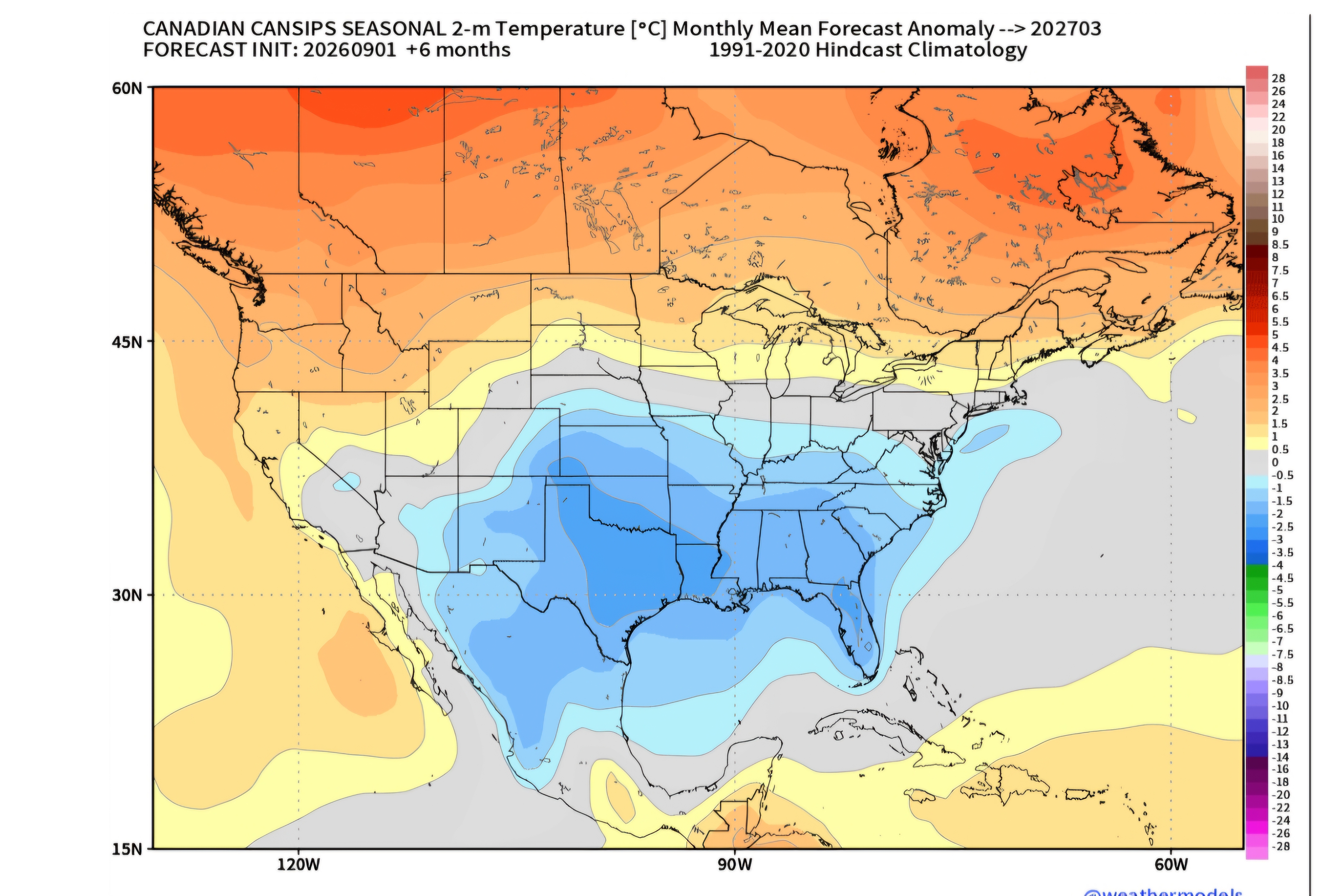
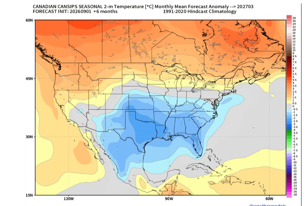
MAR
-
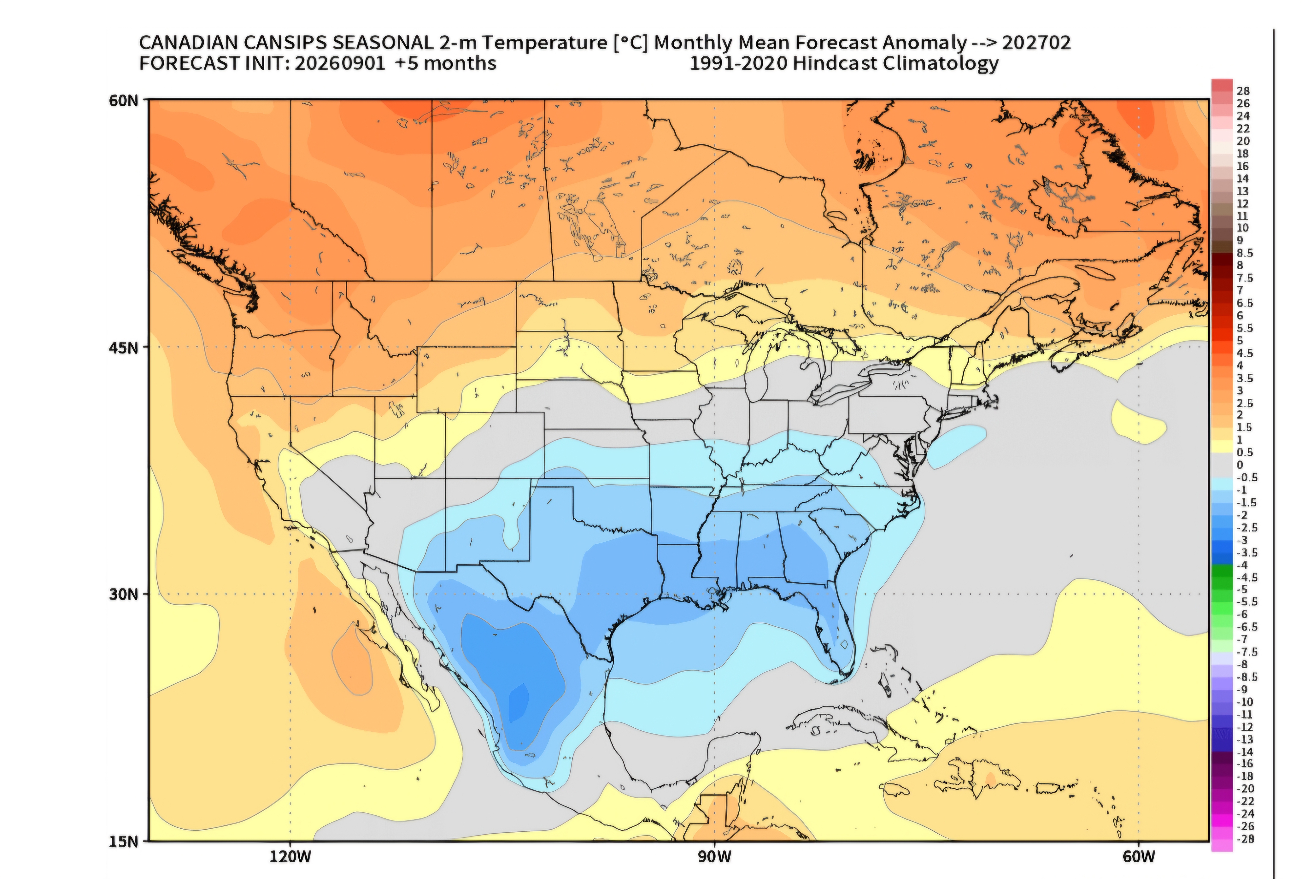
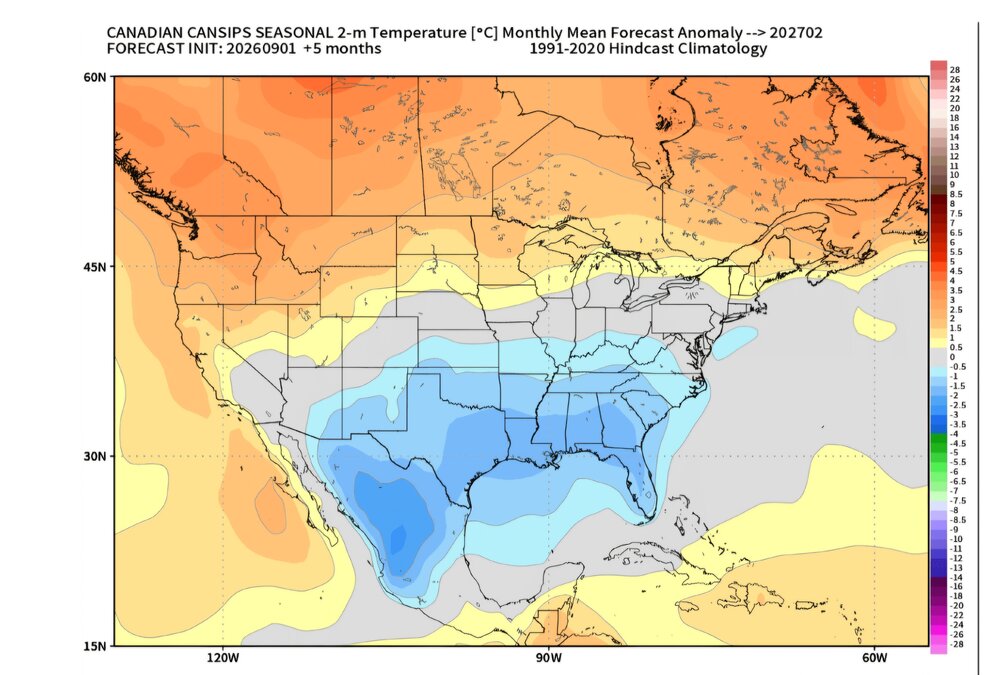
FEB
-
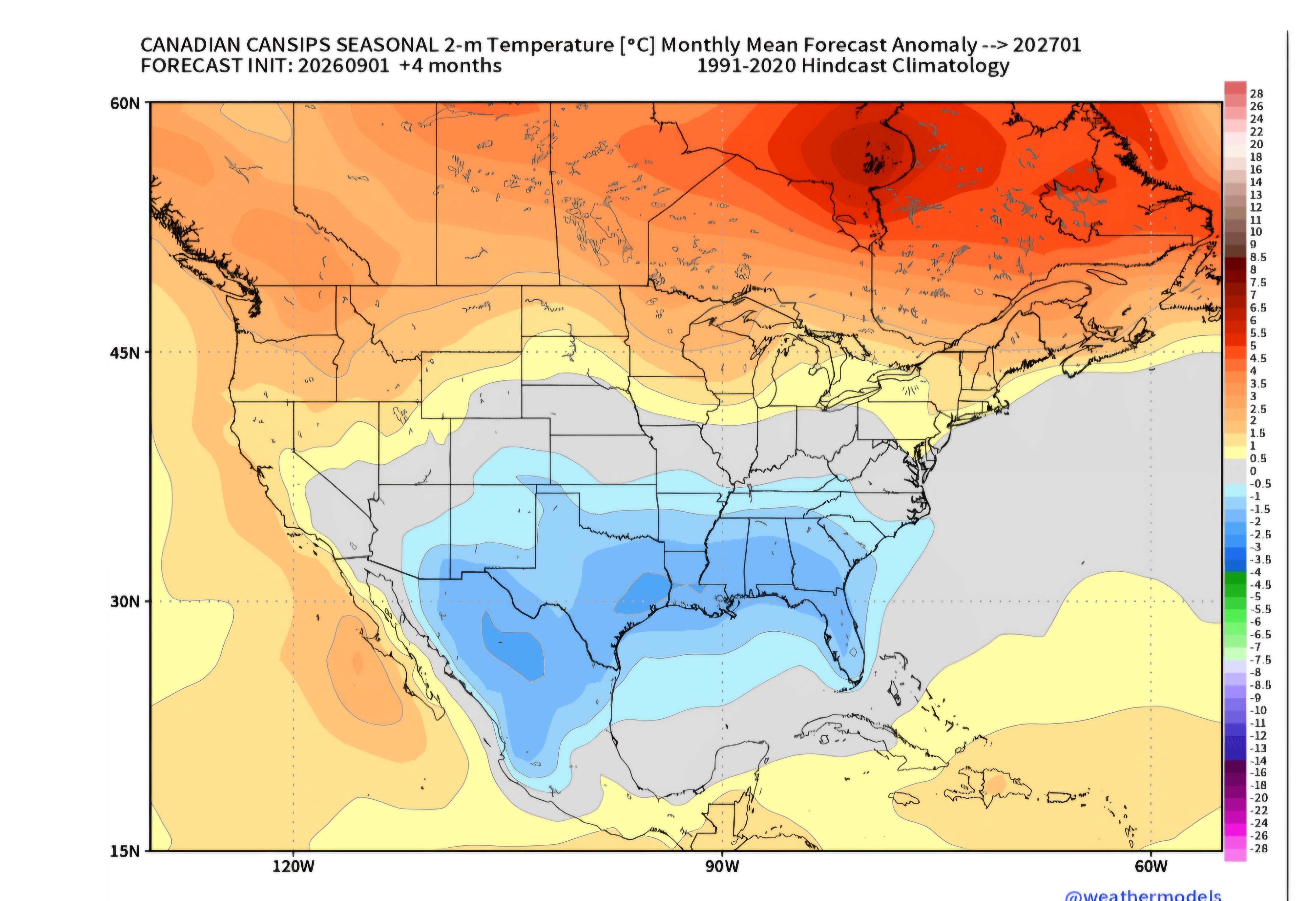
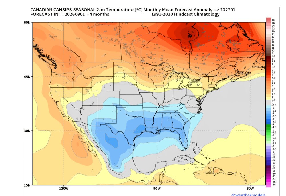
JAN
-
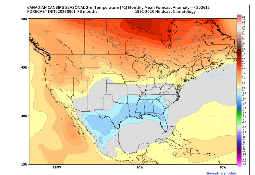
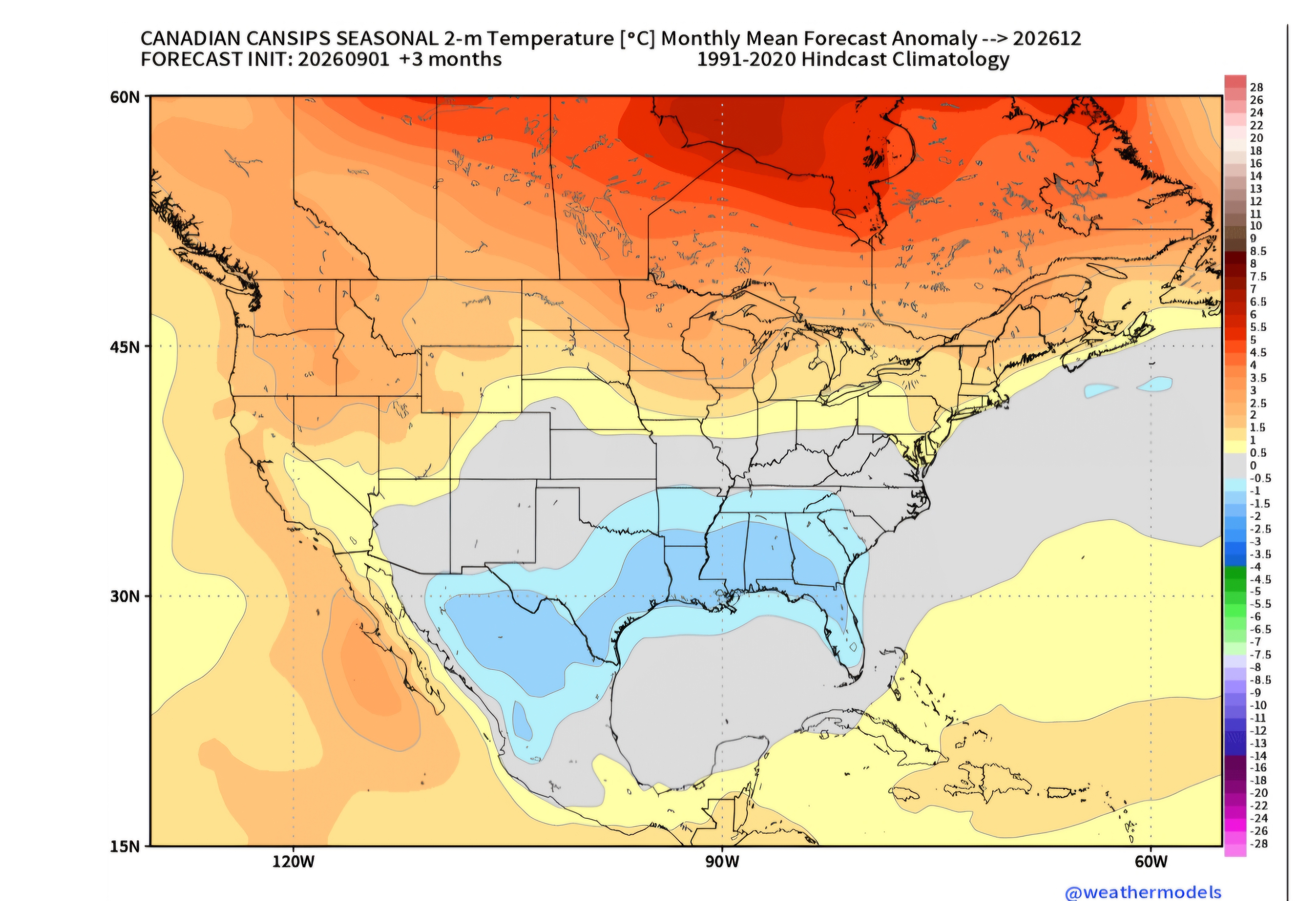
DEC