All Activity
- Past hour
-
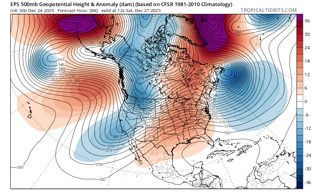
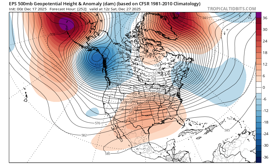
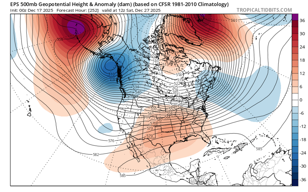
This is likely a 3-5 event for NYC metro area. Consider it a big win given then extreme -PNA (full latitude trough down to Baja) that’s going to be in place during this event
-

26th-27th event, coming at us like a wounded duck.
Damage In Tolland replied to Go Kart Mozart's topic in New England
What about C and E CT? -
White Christmas Miracle? December 23-24th
Arnold214 replied to Baroclinic Zone's topic in New England
11.5" at my place. Still going strong. animated.mov -
The model forecasts always kept the warmest to our SW which isn’t a surprise. The warm up during the 17th to the 25th did beat expectations on the warmest few days which has been a common occurrence since 2011 and even prior to that. The -NAO linking up with the Southeast Ridge will actually help us out for a change this weekend as the high will hold in to our NE for a colder solution and keep the storm track south. You can see how much the models changed for Saturday from the earlier runs. New run more -NAO linkage with Southeast ridge for rare favorable solution Old run Southeast ridge and -NAO separate

-

26th-27th event, coming at us like a wounded duck.
UnitedWx replied to Go Kart Mozart's topic in New England
That'd be great... but pretty bold at this point. And can someone pin this? -

Boxing Night Snow/Sleet/Ice Dec 26-27 Storm Thread/Obs.
penndotguy replied to Mikeymac5306's topic in Philadelphia Region
I mean how realistic is this with the strong blocking? I haven’t looked at it yet unless the High is moving out quicker than previously modeled. -

26th-27th event, coming at us like a wounded duck.
Snowcrazed71 replied to Go Kart Mozart's topic in New England
Well, 2 weather outlets already have snow maps up. Once takes the 3"-6" from the Connecticut River West, to the East of the river 2"-4"/1"-3". Another has the Southwest 1/3rd in the 3"-6", the middle chunk of the state 2"-4", and the northeastern corner 1"-3". They must feel more confident with the Euro and also the fact the models have bumped NE somewhat. -

26th-27th event, coming at us like a wounded duck.
HoarfrostHubb replied to Go Kart Mozart's topic in New England
Tick tick tick. -

26th-27th event, coming at us like a wounded duck.
The 4 Seasons replied to Go Kart Mozart's topic in New England
Euro looks great S/SW CT special -

26th-27th event, coming at us like a wounded duck.
MJO812 replied to Go Kart Mozart's topic in New England
Slowly bumping north -
26th-27th event, coming at us like a wounded duck.
UnitedWx replied to Go Kart Mozart's topic in New England
In a way, yes... but the northern edges look to be the same or even eroded slightly more. We need a few more tics to have this be anything but congrats NYC cop -
Blocking is easing up to make this storm go slightly further north. Now the interior areas of NY look like the jackpot. Nothing wrong with a few inches though.
-

White Christmas Miracle? December 23-24th
mahk_webstah replied to Baroclinic Zone's topic in New England
But psychologically? -
I was looking at the ensembles yesterday, and I agree the Jan 3-8 timeframe is one to watch.
-
White Christmas Miracle? December 23-24th
HoarfrostHubb replied to Baroclinic Zone's topic in New England
You won’t melt much -
Although it's nice to see snows again I do hope we can score at least one classic benchmark track this winter. Unfortunately although we're getting a lot of help on the Atlantic side, the fast and furious Pacific jet is still preventing those classic KU NESIS tracks of the past. If the jet can relax even briefly we might get a chance
-
Id take the 0z Euro run just as currently modeled for Sunday and NYD, but hopefully it'll shift south a bit to get many others in on it too.
-
Oh the idiot is back. Hi idiot. Did you bother to read where I said “FWIW” and “guru” (being sarcastic)? Nevermind, you’re too much of an airhead to comprehend something that complicated. Man, you are really stupid. No clue, none….
-

Boxing Night Snow/Sleet/Ice Dec 26-27 Storm Thread/Obs.
anthonyweather replied to Mikeymac5306's topic in Philadelphia Region
Kinda a given. Warm nose always wins out Real mess coming -

White Christmas Miracle? December 23-24th
TheMainer replied to Baroclinic Zone's topic in New England
5.75" here and -Sn, radar looks paltry, but maybe we squeeze 6 inches. Id say at least 12:1 ratios. Congratulations Dryslot, glad I don't have to drive to KLEW area today! -
So the guy you think is a quack is now correct because of this bold prediction
-
The Kuchera map
-
FWIW, The stratospheric guru Judah Cohen thinks there’s going to be a major strengthening of the SPV in January
-
What map? The forecast for the dec 23rd event?
-

Central PA Winter 25/26 Discussion and Obs
mahantango#1 replied to MAG5035's topic in Upstate New York/Pennsylvania
This could be a bad storm in terms of freezing rain, and some wind, and models look like the temps on most of models not breaking the freezing mark until Sunday.