All Activity
- Past hour
-

2026-2027 Super El Nino
PhiEaglesfan712 replied to Stormchaserchuck1's topic in Weather Forecasting and Discussion
Makes sense. For about 50 years (before 2015-16), many of the strongest el ninos were followed by the strongest la ninas: 1972-73 super el nino -> 1973-76 la nina (with 1973-74 and 1975-76 being strong la ninas) 1982-83 super el nino -> 1983-85 la nina 1986-88 strong el nino -> 1988-89 strong la nina 1997-98 super el nino -> 1998-2001 la nina (with 1998-2000 being a strong la nina) 2009-10 strong el nino -> 2010-12 la nina (with 2010-11 being a strong la nina) -
The 0Z Euro is the 1st one that I can recall with TCG of 91L. It even gets to borderline TS status S of the W FL panhandle Tue night
-
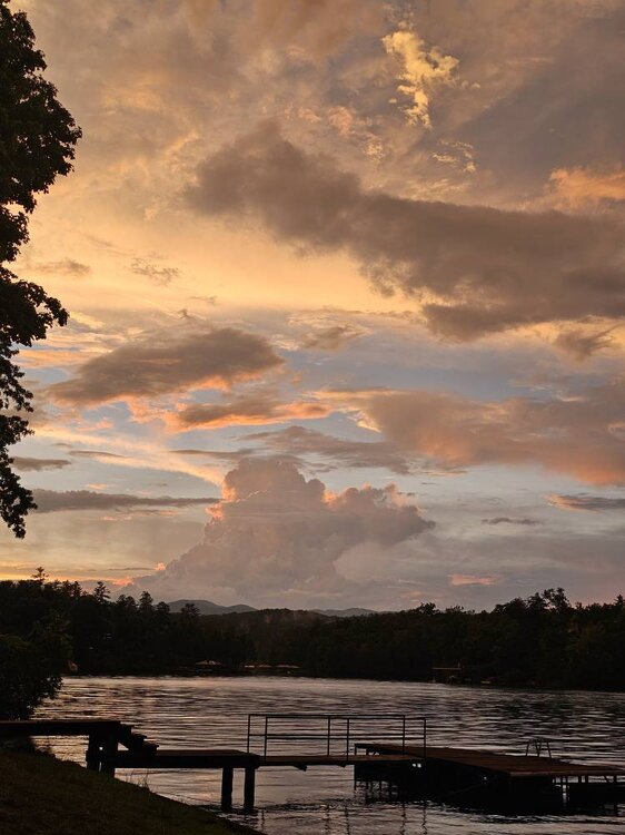
Tonight's sunset was freaking stellar! Sent from my SM-G998U using Tapatalk

-
The Asheville airport got hammered yesterday with 3.29 inches of rainfall shattering the old record of 1.61 inches. Very impressive storm there.
- Today
-
0Z UKMET: 5th run in a row of having a TD (TCG tomorrow) as well as a TS (upgraded Mon night) but doesn’t get as strong as prior 2 runs; mainly WNW movement to SE LA Wed night NEW TROPICAL CYCLONE FORECAST TO DEVELOP AFTER 12 HOURS FORECAST POSITION AT T+ 12 : 27.4N 85.2W LEAD CENTRAL MAXIMUM WIND VERIFYING TIME TIME POSITION PRESSURE (MB) SPEED (KNOTS) -------------- ---- -------- ------------- ------------- 1200UTC 19.07.2026 12 27.4N 85.2W 1011 23 0000UTC 20.07.2026 24 28.0N 85.1W 1008 25 1200UTC 20.07.2026 36 27.7N 85.5W 1007 27 0000UTC 21.07.2026 48 28.0N 85.4W 1005 31 1200UTC 21.07.2026 60 28.6N 86.1W 1004 36 0000UTC 22.07.2026 72 28.9N 86.6W 1004 38 1200UTC 22.07.2026 84 29.7N 88.3W 1004 46 0000UTC 23.07.2026 96 28.9N 89.5W 1006 36 1200UTC 23.07.2026 108 29.4N 90.7W 1009 35 0000UTC 24.07.2026 120 CEASED TRACKING
-

Saturday, July 18, 2026 Thunderstorm/Severe Weather Potential
WxWatcher007 replied to weatherwiz's topic in New England
The underrated days are often the best days. Tends to be a good rule of thumb around here. So many of our higher end days seem to be conditional, so it's no surprise that up here those conditions are harder to meet than most other places that get storms. -

2026 Mid-Atlantic Severe Storm General Discussion
high risk replied to Kmlwx's topic in Mid Atlantic
Looks somewhat similar to today, with perhaps weaker instability but better wind fields. Same idea of a poorly-timed front, but plenty of storms forming on a lee or some other type of pre-frontal trough. -

Saturday, July 18, 2026 Thunderstorm/Severe Weather Potential
WinterWolf replied to weatherwiz's topic in New England
Amazing how we can have a lot of headlines….and zero happens T Storm wise…hmmm. We used to it. Although I don’t need any hail damage to my vehicle…so it’s not that disappointing. -
Saturday, July 18, 2026 Thunderstorm/Severe Weather Potential
WinterWolf replied to weatherwiz's topic in New England
Ahh that sucks…it poured here real good. Move back to Bristol..more snow, and more rain …WIN WIN. -
Upton rain totals are a good bit lower than I expected. Highest in Suffolk County is 2.58" in N Babylon. Radar estimates up to 3.5"-4" in spots. This was before Round 2?
-

Saturday, July 18, 2026 Thunderstorm/Severe Weather Potential
codfishsnowman replied to weatherwiz's topic in New England
Well we didn't even get much rain lol -
Saturday, July 18, 2026 Thunderstorm/Severe Weather Potential
WxWatcher007 replied to weatherwiz's topic in New England
We bust. -
0.71” brings the MTD to 6.40”
-
There still hasn’t been so far this summer a 100 F high at either Columbia or Augusta. Considering how hot this summer has been and with them often being two of the hottest for highs, that’s kind of surprising even though they’ve been plenty hot with 11-12 days in the upper 90s.
-
Saturday, July 18, 2026 Thunderstorm/Severe Weather Potential
WinterWolf replied to weatherwiz's topic in New England
Zero severe here in central CT. Not even a rumble. But good rain’s, so it was a gain. -

Saturday, July 18, 2026 Thunderstorm/Severe Weather Potential
OrangeCTWX replied to weatherwiz's topic in New England
Was in NYCA for fanaticsfest today. Man they were getting clobbered for a while around noonish. But looks like we got about 1.50 inches of rain back home, but no severe per my wife. Bleh. -
We were on the edge in Garner likely got a couple of tenths-not bad Moderate rain -30 mins
-
Saturday, July 18, 2026 Thunderstorm/Severe Weather Potential
WinterWolf replied to weatherwiz's topic in New England
Nothing but strataform rain here…in both waves. A complete bust in regardes to anything severe. I don’t even think we had a rumble lmao. Just goes to show, You just don’t know….especially with regards to severe in SNE. But good soaking rains we did get. -

2026-2027 Super El Nino
Stormchaserchuck1 replied to Stormchaserchuck1's topic in Weather Forecasting and Discussion
CFS has a huge trend bias. I would like to see cooler subsurface waters start to appear. It significantly precedes. I remember seeing an image of Dec 1972 where the whole subsurface was extremely cold during Super Nino. -

2026-2027 Super El Nino
GaWx replied to Stormchaserchuck1's topic in Weather Forecasting and Discussion
The CFS has been hinting at this possibility based on its very sharp record-paced cooling of 3.4 from Dec to Mar. -
00z 4k nam wants to bring a line into the metro Monday night.
-
Man, that was fun. What a storm. Insane rain in fuquay! Same as last Sunday night!
-

Saturday, July 18, 2026 Thunderstorm/Severe Weather Potential
dendrite replied to weatherwiz's topic in New England
Ditto here this month. And I’m willing to flood CT until I can get it. -

Saturday, July 18, 2026 Thunderstorm/Severe Weather Potential
CCHurricane replied to weatherwiz's topic in New England
Getting ready here in Barnstable for this MVY cell to move through. -
2026-2027 Super El Nino
Stormchaserchuck1 replied to Stormchaserchuck1's topic in Weather Forecasting and Discussion
July has been a really wet month since 2017, so it might have less to do with the El Nino and more to do with the pattern. We'll find out after this month I think.