
All Activity
- Past hour
-
Pretty serious organizational trend ongoing. Would not shock me to see some significant strengthening soon. This might be one we are posting about “thankfully not having more time over water”. Outflow looks well established and storms are clearly aligning the MLC and newly formed SLC. Starting to see winds ramp up on buoy and oil rig obs too
-
 best online mexican pharmacy: MexiPh or order medicine from mexico
 -
The reality split the difference: sprinkles, not enough to need the umbrella, but just enough to keep me from reading while walking.
-

September 2026 Medium/Long Range
Stormchaserchuck1 replied to JenkinsJinkies's topic in Mid Atlantic
Rockies ridge has been the pattern for a while.. +6F anomalies for almost a year is impressive! -
Hopefully!
-
September DCA _ NYC _ BOS _ ORD _ ATL _ IAH _ DEN _ PHX _ SEA 1.9 1.1 0.7 3.0 3.1 2.5 1.9 1.8 0.4
-
Latest HWRF says our first hurricane of 2026 will make landfall on the Tx/La border about this time tomorrow...
-
Tropical Depression Five Discussion Number 2 NWS National Hurricane Center Miami FL AL052026 400 PM CDT Mon Aug 31 2026 The Air Force Hurricane Hunter aircraft data through early this afternoon showed the low-level circulation of this system gradually becoming better defined, and it was sufficient to designate it as Tropical Depression Five for the 18 UTC intermediate advisory. This is consistent with the improved radar and satellite presentation of the system, with a prominent curved band now evident to the south of the center. The aircraft measured peak 850-mb flight-level winds of 38 kt earlier today, and TAFB provided a T2.0/30 kt Dvorak estimate at 18 UTC. These data support a 30-kt intensity for this advisory. Another Air Force Hurricane Hunter mission is scheduled to investigate the system tonight. The center of the depression lies to the north and east of prior estimates based on the aircraft data and recent surface observations. A low-level ridge over the southeastern United States is steering the system toward the west-northwest (300/5 kt), and this general motion should continue through the next couple of days. The system is expected to move onshore along the northwestern Gulf Coast within the warning area on Tuesday, with the updated 24-h forecast point just offshore. There were no significant changes to the track guidance this cycle, and the updated NHC forecast was adjusted slightly north of the previous prediction mainly due to the repositioning of the center. The tropical cyclone is fairly compact and has a small radius of maximum wind. Although it only has about a day over the very warm Gulf waters, strengthening is expected within a generally low shear environment. Since the small size of the system makes it more susceptible to quicker intensity changes, the NHC intensity forecast has been raised and now lies above almost all of the intensity guidance, including HCCA and IVCN. The legacy hurricane regional models (HWRF/HMON) show even more strengthening than is forecast here. While this does not appear to be the most likely scenario, interests in the warning area are reminded to closely monitor the latest forecast updates. Key Messages: 1. The system is expected to bring tropical storm conditions to portions of the Upper Texas and southwestern Louisiana coasts on Tuesday. A Tropical Storm Warning is in effect from Port Bolivar, Texas, to the Vermilion/Iberia Parish Line, Louisiana. 2. Heavy rain will impact parts of the Upper Texas coast through east-central Texas into far Southwest Louisiana Tuesday and Wednesday as the system tracks inland. Flash flooding is likely across this region, especially in urban areas. River flooding may also be possible. 3. A Storm Surge Watch has been issued from High Island, Texas, to the Vermilion/Cameron Parish Line, Louisiana. Peak values of up to 4 feet above ground level are possible within the watch area. FORECAST POSITIONS AND MAX WINDS INIT 31/2100Z 28.2N 91.5W 30 KT 35 MPH 12H 01/0600Z 28.8N 92.4W 40 KT 45 MPH 24H 01/1800Z 29.6N 93.8W 50 KT 60 MPH 36H 02/0600Z 30.6N 95.2W 30 KT 35 MPH...INLAND 48H 02/1800Z 31.6N 96.1W 20 KT 25 MPH...POST-TROP/INLAND 60H 03/0600Z...DISSIPATED $$ Forecaster Reinhart
-
Sun finally appeared around 3pm. Temps in the low-mid 70's. Another failed point cast. Should see 80's tomorrow, but Lake winds return for more 70's after that, which is fine. Squeeze out what little summer is left.
-

2026 Spring/Summer Mountain Thread
franklin NCwx replied to Buckethead's topic in Southeastern States
We made it! Hopefully after this we we are done with the heat -
 September DCA _ NYC _ BOS _ ORD _ ATL _ IAH _ DEN _ PHX _ SEA 2.0 1.2 1.0 1.5 2.2 2.5 2.0 1.5 -0.5
 -
-

Augdewst 2026: Summer's Last Stand
WxWatcher007 replied to Prismshine Productions's topic in New England
Our last major - Today
-
Septorcher 2026 Discussion - Endless Summer
WxWatcher007 replied to Damage In Tolland's topic in New England
Not far from getting a name. -
Welcome to the new norm. There is no more September, just August part deux.
-
Yes, a couple of drips here and can see the sun at the same time.
-
A few more showers came through yesterday and deposited 0.29" to bring us to 4.37" for August.
-

Augdewst 2026: Summer's Last Stand
jlauderdal replied to Prismshine Productions's topic in New England
They get caught up in eye candy IR images and crazy model runs. -
https://quickph.shop/# overseas online pharmacy
-
Rain did not materialize here AGAIN, only a few hundredths (.64" for the month). Currently 77/70, a warm and humid end met summer.
-

Augdewst 2026: Summer's Last Stand
powderfreak replied to Prismshine Productions's topic in New England
Chamber approved.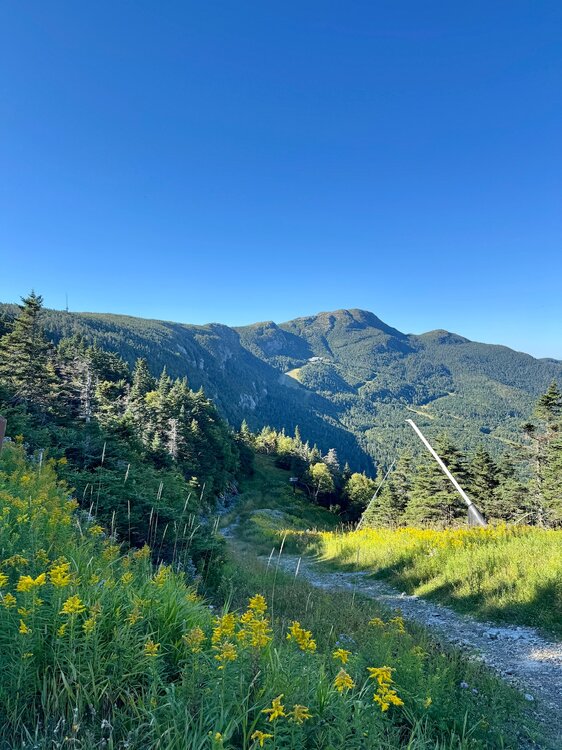
-

Septorcher 2026 Discussion - Endless Summer
ineedsnow replied to Damage In Tolland's topic in New England
this could be interesting for Texas and Louisiana.. looking better and better with 16 or so hours to go.thumb.jpeg.83fcaf877297d3aff9596b42ba3eb76c.jpeg)
-

Fall 2026 Medium/Long Range Pattern Thread
Carvers Gap replied to John1122's topic in Tennessee Valley
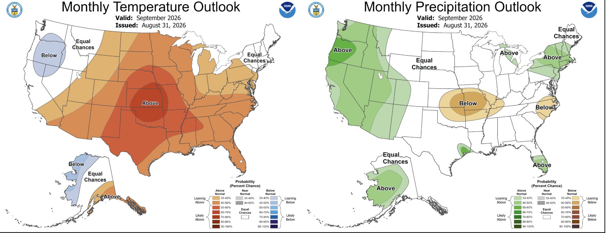
I think this breaks down around the first of October. LR ext models are hinting that we have about four more weeks of this furnace, and then it flips. I hate hot September weather with a white hot passion. -
Thanks, Don. I can tell that Chris Martz has been affecting JB recently. Until recently, I recall JB (like many other mets) used to mention “heat dome” regularly without a sarcastic tone. But this summer whenever he mentions it, he often does so with a sarcastic tone. He doesn’t go out of his way to say it isn’t appropriate. But he clearly sounds like he’s making fun of the term and isn’t as comfortable using it like in the past.
-
Those showers coming in from PA are weakening as expected. Looks like just some sprinkles for our area.













.jpeg.7237e6ab58d844c2e9763445af52395d.jpeg)

