All Activity
- Past hour
-
I bet Bastardi will have a thing or two to say about this upgrade.
-
Closing in on 0.50” which is more than most models had for here.
-

2025-2026 ENSO
40/70 Benchmark replied to 40/70 Benchmark's topic in Weather Forecasting and Discussion
I think this season can still safely be lumped into the solar max bin. -
I expected a long wait, and here we are. Expected to become a hurricane. Outside shot at MH. Peak Season Forecast (Aug 20-Oct 20) Named Storms: 10 (2) Hurricanes: 6 (0) Major Hurricanes: 3 (0) Fernand, Gabrielle
-
Tropical Storm Gabrielle Discussion Number 2 NWS National Hurricane Center Miami FL AL072025 Issued by the NWS Weather Prediction Center College Park MD 1100 AM AST Wed Sep 17 2025 Satellite imagery this morning indicates that the large system is not well-organized, with an elongated circulation oriented from north-northwest to south-southeast containing a few embedded swirls. The advisory center is a mean center of those swirls, with any associated convection well east of the position due to southwesterly shear. While it wouldn't appear so from conventional satellite data, a recent scatterometer pass indicates upwards of 40-kt winds present, generally northeast and southeast of the center of circulation. Although the system is at best marginally well defined, there is enough data to support an initial intensity of 40 kt, and the depression is named Gabrielle. Little strengthening is anticipated over the next 48 hours as Gabrielle faces an unfavorable shear environment from an upper-level trough and a possible center re-formation, and the forecast intensity remains nearly steady through Friday. By this weekend, a more conducive environment is anticipated, which should allow for gradual intensification. Gabrielle is forecast to become a hurricane by 96 hours. The NHC intensity forecast remains fairly similar to the previous forecast cycle, but it should be noted that there remains considerable spread in the solutions and overall forecast intensity confidence is low. Gabrielle is well away from land and about midway between the Cabo Verde Islands and the Windward Islands. The current estimated motion is north-northwestward, but this is highly uncertain as the center could be re-forming to the north. The system is forecast to move northwestward to west-northwestward due to the subtropical ridge for the next several days. While the forecast has been adjusted to the north from the previous one, this is almost exclusively due to the jump in the initial position. This is a highly uncertain forecast until a better defined center forms. Based on the recent trends, this system should pass well east and north of the Windward and Leeward Islands, but interests in Bermuda should monitor forecasts during the next several days. FORECAST POSITIONS AND MAX WINDS INIT 17/1500Z 17.5N 46.6W 40 KT 45 MPH 12H 18/0000Z 19.5N 48.5W 45 KT 50 MPH 24H 18/1200Z 20.8N 50.6W 45 KT 50 MPH 36H 19/0000Z 21.8N 52.6W 45 KT 50 MPH 48H 19/1200Z 22.7N 54.6W 45 KT 50 MPH 60H 20/0000Z 23.5N 56.6W 50 KT 60 MPH 72H 20/1200Z 24.7N 58.3W 55 KT 65 MPH 96H 21/1200Z 27.4N 60.8W 65 KT 75 MPH 120H 22/1200Z 30.0N 62.5W 75 KT 85 MPH $$ Forecaster Taylor/Blake
-
BULLETIN Tropical Storm Gabrielle Advisory Number 2 NWS National Hurricane Center Miami FL AL072025 Issued by the NWS Weather Prediction Center College Park MD 1100 AM AST Wed Sep 17 2025 ...GABRIELLE FORMS OVER THE CENTRAL TROPICAL ATLANTIC... ...FORECAST TO REMAIN OVER OPEN WATERS FOR SEVERAL DAYS... SUMMARY OF 1100 AM AST...1500 UTC...INFORMATION ----------------------------------------------- LOCATION...17.5N 46.6W ABOUT 1085 MI...1745 KM E OF THE NORTHERN LEEWARD ISLANDS MAXIMUM SUSTAINED WINDS...45 MPH...75 KM/H PRESENT MOVEMENT...NNW OR 330 DEGREES AT 22 MPH...35 KM/H MINIMUM CENTRAL PRESSURE...1006 MB...29.71 INCHES WATCHES AND WARNINGS -------------------- There are no coastal watches or warnings in effect. DISCUSSION AND OUTLOOK ---------------------- At 1100 AM AST (1500 UTC), the center of poorly defined Tropical Storm Gabrielle was located near latitude 17.5 North, longitude 46.6 West. Gabrielle is moving toward the north-northwest near 22 mph (35 km/h). An erratic northwestward to west-northwestward motion at a reduced forward speed is anticipated across the tropical and subtropical central Atlantic during the next few days. Satellite-derived winds indicate that the maximum sustained winds are near 45 mph (75 km/h) with higher gusts. Little change in strength is forecast during the next 48 hours but some gradual intensification is forecast over the weekend. Tropical-storm-force winds extend outward up to 175 miles (280 km) from the center, primarily in the eastern semicircle of the storm. The estimated minimum central pressure is 1006 mb (29.71 inches).
-
@Gawx
-
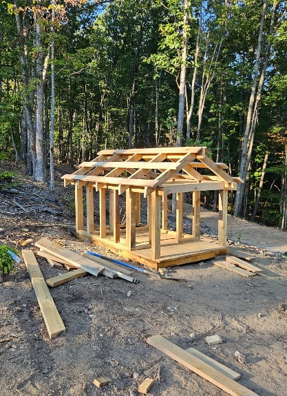
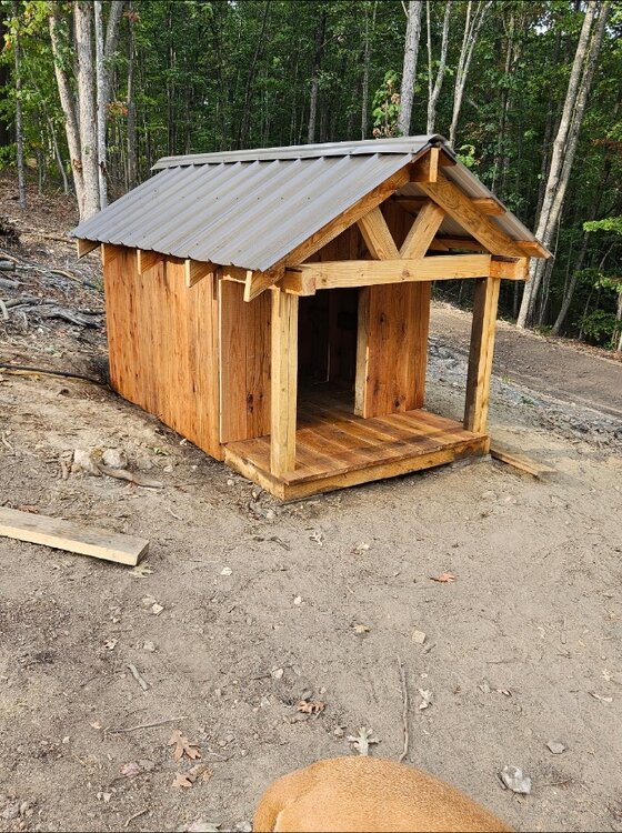
Just finished a really fun/satisfying build on our land. We ended up with 2 wells drilled because the first one had a silt problem and the driller guaranteed a good well. We're using the problem well for irrigation so it's an amazing bonus resource but you can't have 2 well heads on a single permit and permits are expensive. Driller told us to camouflage the problem well. Since it sits at the junction of our main drive and homesite driveway, inspectors will literally drive right past it every time they come. Wife came up with the idea of putting a doghouse there and hiding the well head behind a fake wall inside. Thought it was brilliant so I went to work. I've been milling logs from the land clearing project back in the spring so I have a small mountain of lumber to work with lol. House is framed with yellow and red pine and decked/sided with white oak. Turned out really slick and I'm pretty proud of this build. Adds a really nice touch to the property and most importantly... the dog loves it lol

-
Up to .56 today. Add in the .10" I got last evening and this has actually turned into a solid event. We need a lot more to make up for the past 2 months, but it's a start.
-

September 2025 OBS-Discussion centered NYC subforum
donsutherland1 replied to wdrag's topic in New York City Metro
For New York City, the connection isn't as strong. Since 2000, a wet fall is more likely to be followed by a wet winter. Dry falls were only slightly more likely to be followed by wet winters (using the 1991-2020 baselines) for New York City (Central Park). Drier than Normal Falls: 54.5% were followed by above-normal winter precipitation (Last: Fall 2024/Winter 2024-2025) 45.5% were followed by below-normal winter precipitation (Last: Fall 2017/Winter 2017-2018) Wetter than Normal Falls: 61.5% were followed by above-normal winter precipitation (Last: Fall 2023/Winter 2023-2024) 38.5% were followed by below-normal winter precipitation (Last: Fall 2022/Winter 2022-2023) -

September 2025 OBS-Discussion centered NYC subforum
Rmine1 replied to wdrag's topic in New York City Metro
Drizzle, brightwaters 67 -

Occasional Thoughts on Climate Change
Typhoon Tip replied to donsutherland1's topic in Climate Change
Yet ... AC only adds more to the anthropomorphic forcing integral, too. Humanity needs to accept an opposition to using fossil fuels to power the grid, being far more apropos. CC worsening will incur increased frequency of those types of predicaments, like the AC catch-22. It may seem like just a pie slice in the total anthropomorphic forcing but situations like that will get more common. Obviously ... not a novel assertion to suspect that, just sayn' Expediency to solve local/regional imminent threat to health and safety forces taking measures within those realms to stop the death, now. And yet ...as those measures provide immediate protection they only augment the why-for crisis is at hand in the first place. It's just laughable to know what the solution really should be, while humanity divisively obfuscates from seeing it ... Instead, application of all these duct tape on a leaking dam strategies that evade the real problem. I keep coming across all these articles featuring these technological discoveries on how to combat x-y-z and I'm like ...Jesus. If you're nauseated by the potion, just stop fucking drinking the potion. It all comes back to what Don and I were ruminating over a couple of weeks ago ... the insidious nature of CC. It has to appeal directly to the natural senses before the awareness moves from intellectualism and debate to a state of prevalence. It's just the evolutionary biology of all organisms, their impulse response to crisis is slaved to that system. The human species is no different... The difference here is that we are just beginning to see CC finally appealing ... but it will probably take some time to wake up the species awareness fully enough. A time in which we'll see these follies. -
Don't have a total but got several rounds of very hard rain in Fallston last evening into the overnight. Most welcome.
-

September 2025 OBS-Discussion centered NYC subforum
nycwinter replied to wdrag's topic in New York City Metro
it feels like a mid october day chilly gusty ocean breeze perfect hoodie weather.. -
Well, luckily it was pretty bad at the forecast for this one.
-
September 2025 OBS-Discussion centered NYC subforum
donsutherland1 replied to wdrag's topic in New York City Metro
Picard, My data comes mainly from: https://xmacis.rcc-acis.org/ I periodically use teleconnections data: https://ftp.cpc.ncep.noaa.gov/cwlinks/ and Climate Data: https://www.ncei.noaa.gov/access/monitoring/climate-at-a-glance/ Most of this data can readily be downloaded or converted into .CSV and .XLSX files -
In Frederick at work and we have had on and off heavy rain since around 8:30AM. At least 5 rumbles of thunder as well. Very nice over perform from the showers forecasted.
-
Yeah that band has been great for the Frederick region. Even we got a decent amount overnight (now that summer is almost over it can rain here)
-
Had lawn seats last night for a show at Jiffy Lube. Got absolutely drenched to the core
-
2025-2026 ENSO
40/70 Benchmark replied to 40/70 Benchmark's topic in Weather Forecasting and Discussion
Mild Autumn doesn't particularly concern me. -
Just went over an inch here. I am really surprised. With the .27 I got before the reset at midnight this is a pretty good system. Just got some thunder.
-
Yeah. Not sure how much time I’ll be spending up there long term, but so far it’s been a few days a month. Incredibly beautiful up there. It’s a whole different world with the small town vibe and much colder climo. I definitely don’t want snow late April though lol.
-
what a bust
-
So far we aren’t and haven’t been seeing recurving typhoons. They are moving straight west into Asia like this current one is going to do….causing the upcoming warm pattern
-
You have been cleaning up on me over the past several events - .27" of rain fell at home. To your point about hearing it coming down, .2" of my total fell in 11 minutes from 1:35am through 1:46am. You must have gotten in on an additional band that missed me.