All Activity
- Past hour
-

September 2025 OBS-Discussion centered NYC subforum
forkyfork replied to wdrag's topic in New York City Metro
lol
-

September 2025 OBS-Discussion centered NYC subforum
IrishRob17 replied to wdrag's topic in New York City Metro
My house it at 385' but I typically have to drive over a hill that is just over 500' to get to the main road. To the point of how shallow the inversion can be it always cool to drive through it and have the car windows instantly fog up. There are times with freezing rain when I still have ice on everything and most of it has melted on the hill, which is only a half mile from my yard. -

2025 Atlantic Hurricane Season
WxWatcher007 replied to BarryStantonGBP's topic in Tropical Headquarters
Yeah it’s time to break out the discussion with the trends continuing. Threads on both coming now. -
The tropics are active now with three systems being monitored. This is the thread for the current central Atlantic cherry. Real OP analysis forthcoming.
-
GYX has us with a 50% of >0.25". We'll need a bit more to end the drought, maybe like the 5.54" dumped on Sept. 21, 1966 at NYC that ended the 1960s MA/SNE drought (though it was several wet months later before the end was confirmed). At the time, that deluge was Central Park's 3rd greatest daily precip, also the most for a non-TC event. Another full sun day, though w/o the frost - upper 30s for the low after the 30/29 on Sat/Sun.
-

Central PA Summer 2025
Mount Joy Snowman replied to Voyager's topic in Upstate New York/Pennsylvania
Low of 60. I'll be in Happy Valley for this weekend's whiteout game against Oregon so I'm keeping a close eye on things. Somewhat optimistic at this point that the bulk of the activity will have moved through and Saturday should end up as a pretty solid day. -

September 2025 OBS-Discussion centered NYC subforum
Stormlover74 replied to wdrag's topic in New York City Metro
Seems like they models have zeroed in on Thursday as the day we could see up to inch -
I guess Gertrude or Gladys sound more ominous to you then
-
Models have him as a fish major
-

September 2025 OBS-Discussion centered NYC subforum
SACRUS replied to wdrag's topic in New York City Metro
62 / 54 clouds dividing the area in half SNJ / NYC/NNJ. Warmer the next two days before clouds and more onshore bring the next chance of mod - hvy rainfall with cut off bumping into the Atlantic ridge. Once passed the weekend ridge into the east keep is ovrall warmer beyond. -
2025 Atlantic Hurricane Season
Michelle Davies replied to BarryStantonGBP's topic in Tropical Headquarters
I just said 20/70 and 10/40 -

September 2025 OBS-Discussion centered NYC subforum
MANDA replied to wdrag's topic in New York City Metro
WPC usually on the conservative side so if you are looking / hoping for meaningful rain you gotta like the look of this. As Walt said still a ways off and details not solid but nice starting point.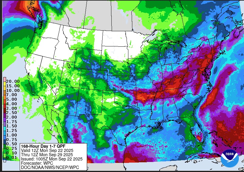
-
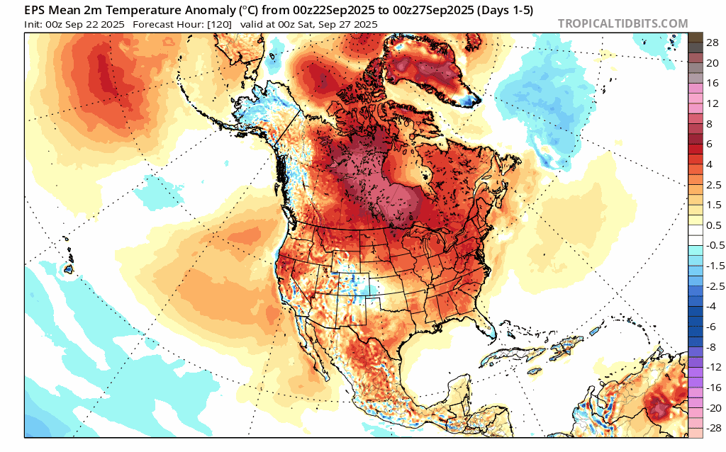
Rest of the month looks A and with regards to temperatures. I’m guessing the major stations will finish the month close to normal.
-

September 2025 OBS-Discussion centered NYC subforum
bluewave replied to wdrag's topic in New York City Metro
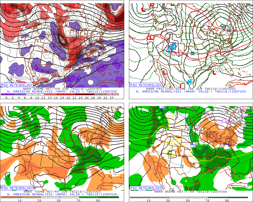
Especially in places like the Adirondacks. I remember wondering as a kid how Old Forge made it down to -52° in February 1979. The Arctic high settled right over that region for perfect radiational cooling. Data for February 18, 1979 through February 18, 1979 Click column heading to sort ascending, click again to sort descending. OLD FORGE COOP -52 STILLWATER RESERVOIR COOP -44 WANAKENA RNGR SCHOOL COOP -41 HINCKLEY 2 SW COOP -40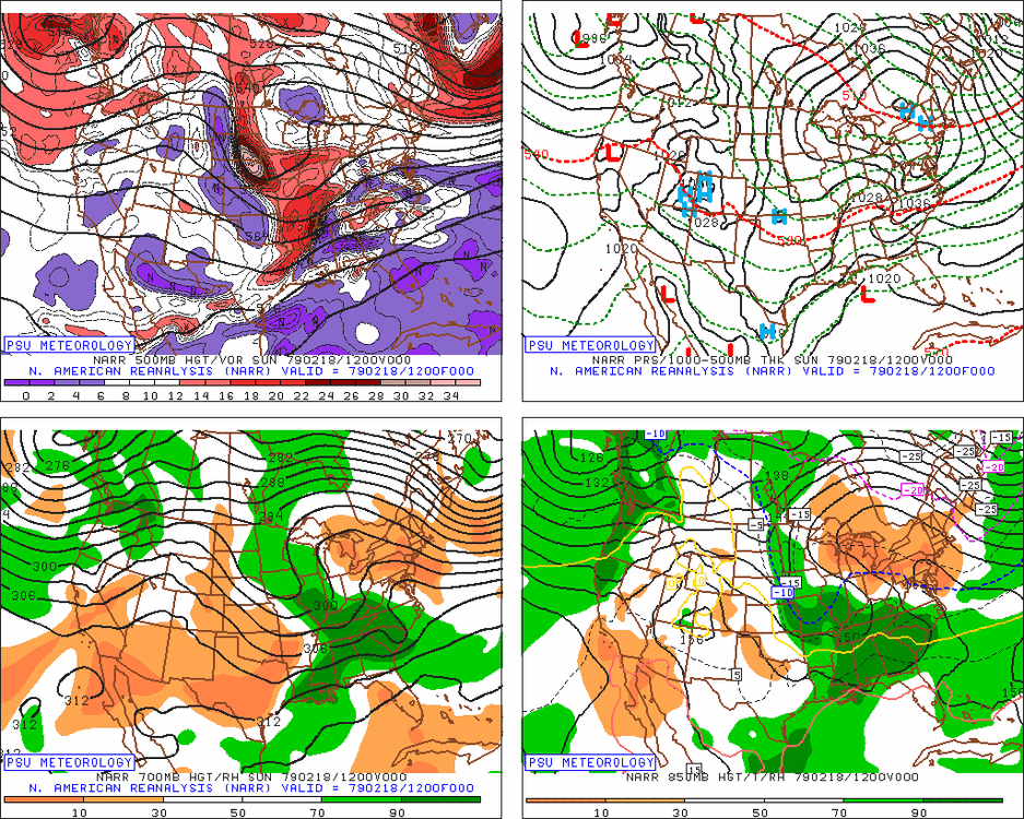
-
Need Sept 28th - 30th dry. Otherwise it can rain all it wants.
-
That would be a normal winter anymore.
-
WB 6Z AI in fantasy range....
-
For you northerners, but us southerners in GA, still seeing low to mid 80's after the next few days of low 90's
-
Sunday River tested their guns the other day. Some cold mornings starting next week might get a few others into test mode. We just need some rain for the ponds.
-

September 2025 OBS-Discussion centered NYC subforum
LibertyBell replied to wdrag's topic in New York City Metro
I think it also has to do with how quickly the cold gets scoured out after the sun comes up. And sometimes we get this kind of cold just before a storm comes in during the winter and a place like FOK goes from the lowest temperatures in the area to being the first ones to change from snow to rain lol. -
September 2025 OBS-Discussion centered NYC subforum
LibertyBell replied to wdrag's topic in New York City Metro
The patterns are astonishingly similar, dryness on both the east and west coast and wetness in between. winter 1984-1985 was cold and dry too (until February when we warmed up very quickly after a frigid January with one of our strongest arctic shots in my lifetime.) -
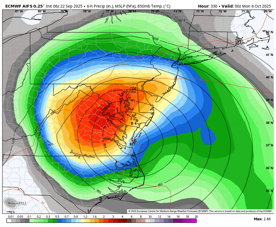
The AOI nearest to the Lesser Antilles may need its own thread due to a potential threat at least to the Bahamas late this week and possibly even the US E coast/Canada. This was a TC on the admittedly untrustworthy GFS as far back as the 0Z 9/18 run and consistently on runs the last couple of days, including some ensembles. Also, the Icon and Euro have at least hints that this may turn into something: East of the Leeward Islands: A tropical wave located about 400 miles east of the Leeward Islands continues to produce disorganized showers and thunderstorms. Environmental conditions appear marginally conducive for slow development over the next few days as the wave moves quickly westward to west-northwestward at 15 to 20 mph. By the latter part of this week, the system is expected to slow down and turn more northwestward, and a tropical depression could form late this week when the system is over the southwestern Atlantic Ocean or near the Bahamas. Regardless of development, gusty winds and showers are expected to affect portions of the Leeward Islands late tonight and Tuesday. * Formation chance through 48 hours...low...10 percent. * Formation chance through 7 days...medium...40 percent
-
September 2025 OBS-Discussion centered NYC subforum
LibertyBell replied to wdrag's topic in New York City Metro
Wow Don, I see there's a lot of years between 1984-1985 and 2024-2025 even though the rainfall amounts were only off by about 2.5 inches. Was September 1984-August 1985 the driest such period during the 1980s decade? -

September 2025 OBS-Discussion centered NYC subforum
FPizz replied to wdrag's topic in New York City Metro
Fake cold like other places are fake warm (anthony) 47 here this morning -
September 2025 OBS-Discussion centered NYC subforum
LibertyBell replied to wdrag's topic in New York City Metro
Frost in the Poconos (MPO) Don?


.thumb.png.4150b06c63a21f61052e47a612bf1818.png)