All Activity
- Past hour
-
So much beer lately
-

September 2025 OBS-Discussion centered NYC subforum
Stormlover74 replied to wdrag's topic in New York City Metro
Euro wetter again
-
Congrats!! Similar to my non-rain chances today.
-
 As complicated a tropical development setup as you’ll ever see. Multiple competing waves, ULL progression, SE trough, a cat 4 hurricane nearby… Good luck making a call and standing on it with this setup
 -
lol f off
-
You’d better look again . N CT had a wet summer
-
Actually, the summer in Connecticut for the northern half of the state was just near normal, where the southern half of the state has been well below normal precipitation wise. So that's not a good correlation to why we're getting early color. Maybe it's just because it's been a more on the dry side?
-

Invest 94L—20% 2 day and 60% seven day odds of development
GaWx replied to WxWatcher007's topic in Tropical Headquarters
94L 6Z Euro at 144 had a strengthening 998 TS moving NNW N of the Bahamas threatening the SE US. 6Z Icon at 120 was well E of Euro 6Z GFS had nothing from this, alone, although it appears to combine its vorticity with 93L and develop that well offshore —————- No UK run has had this as a TC AFAIK as of then. But 12Z UK: TD in NW Bahamas that drifts NE NEW TROPICAL CYCLONE FORECAST TO DEVELOP AFTER 138 HOURS FORECAST POSITION AT T+138 : 25.0N 77.1W LEAD CENTRAL MAXIMUM WIND VERIFYING TIME TIME POSITION PRESSURE (MB) SPEED (KNOTS) -------------- ---- -------- ------------- ------------- 1200UTC 29.09.2025 144 25.6N 76.9W 1010 30 0000UTC 30.09.2025 156 26.0N 76.2W 1009 24 1200UTC 30.09.2025 168 26.9N 74.2W 1008 27 -
Not a drop so far today.
-
This looks like a CMC winter qpf output.
-
Modern conceptualization of "colder" is probably near normal.
-
Will we get the usual three months of fall? OND? Perhaps into January for the Cape?
-
Region 1.2 has warmed again, speakaing to the volatility that Paul mentioned, but the subsurface remains supportive of an east-biased event.
-

September 2025 OBS-Discussion centered NYC subforum
donsutherland1 replied to wdrag's topic in New York City Metro
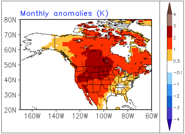
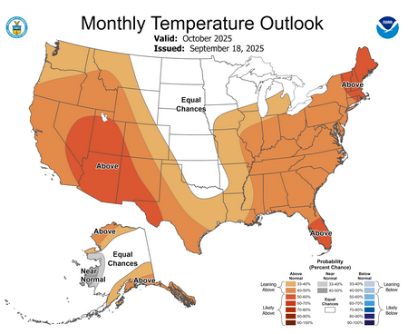
Considering the magnitude of warmth that is likely for the second half of September, the odds are tilted toward a warmer than normal October. It has been a long time since a September 16-30 as warm as this year's will likely be, has been followed by a cool October, even against the 1991-2020 baseline. CFSv2 Forecast for October 2025: Current CPC Monthly Outlook: The most recent ECMWF weekly forecast showed the potential for a cool start to October but very warm conditions in central Canada. So, a warm outcome is not cast in stone, but the combination of the CPC outlook, CFSv2 forecast, and statistical odds suggest that a warmer outcome is more likely than a colder one. Nevertheless, the highest odds of a warmer than normal outcome are probably in the western half of the CONUS and Canada.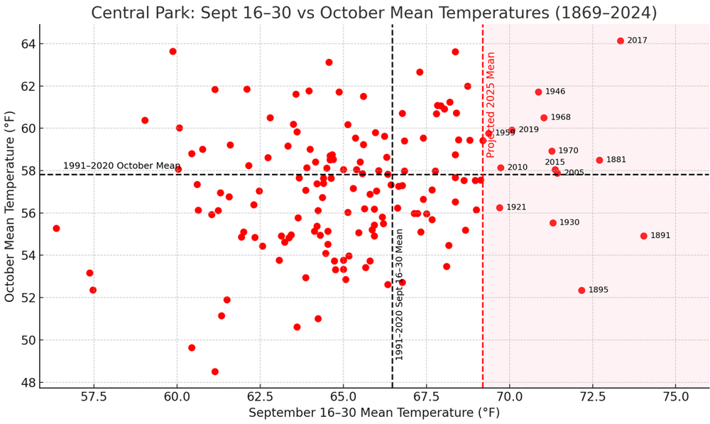
-
96.25%
- Today
-
Sept coming in AN everywhere at month end. Another warm month , Congrats on the rain NNE FTW
-

September 2025 OBS-Discussion centered NYC subforum
steve392 replied to wdrag's topic in New York City Metro
I'll believe it when my new rain gauge actually shows that. My backyard is just dust. -

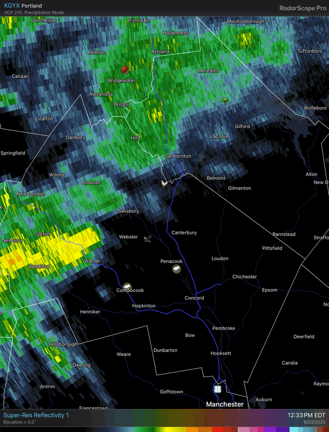
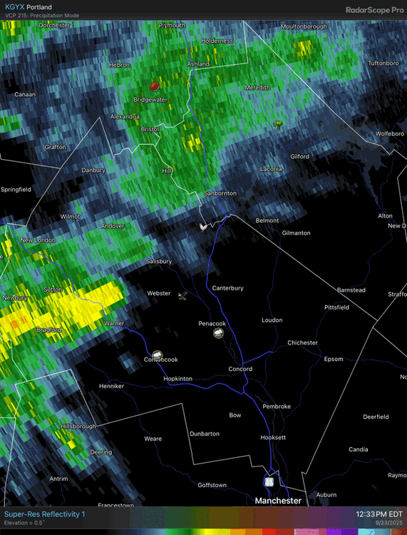
September 2025 OBS-Discussion centered NYC subforum
Picard replied to wdrag's topic in New York City Metro
Clown maps for now. -

September 2025 OBS-Discussion centered NYC subforum
FPizz replied to wdrag's topic in New York City Metro
CMC -
I recall reading something like that a month ago. Actual water coming from the sky - first drops since Sept 7. Colors coming on and looking decent, though leaf drop is way ahead of average - 50-75% drop on ash, 30% on white birch, less on other species (except oak, which is still green. Only foliage loss there is squirrel work).
-

September 2025 OBS-Discussion centered NYC subforum
winterwx21 replied to wdrag's topic in New York City Metro
You'd hope we'd get some heavy rain at some point with this humidity sticking around for the rest of the week. -
September 2025 OBS-Discussion centered NYC subforum
Stormlover74 replied to wdrag's topic in New York City Metro
Rgem a soaker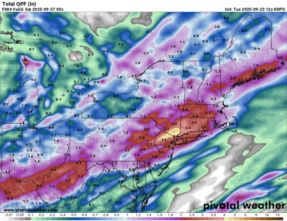
-
same. feels like it is going to be a long fall, meaning that leaf drop will not come all at once (except for the oak trees)
-
You're right, haha. I saw it was the last on the list and assumed Sent from my SM-G970U1 using Tapatalk
-
Yeah looks about the same up at Stowe. I had to go to BTV and back this morning, steady rain the whole way there and back. Seems like most spots are in that third to half inch range. A few up to three quarters in the Underhill area.