All Activity
- Past hour
-
as useless as steve d....and crappy for my area anyway
-
-
This is from a guy who posts at another forum fwiw
-
-
Best run yet verbatim fo mby… I really need to stop looking. It will be what it is, most likely 3-6” fo many
-
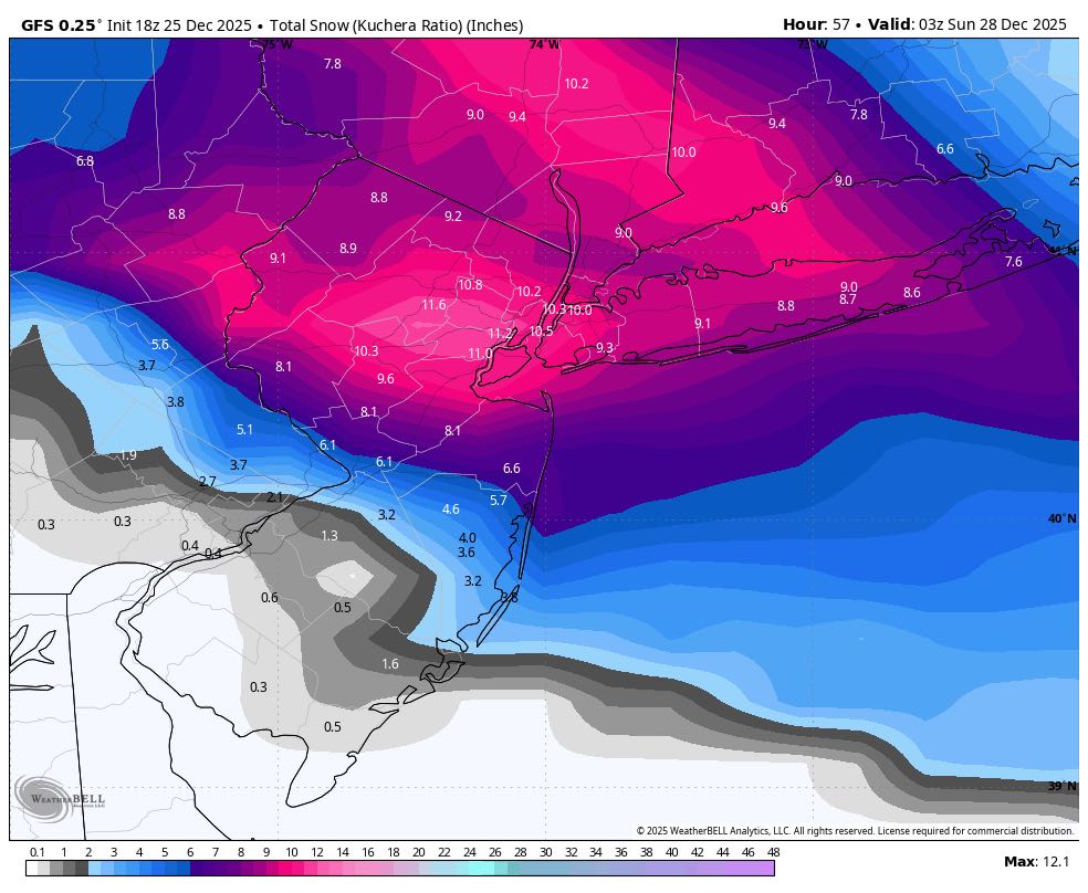
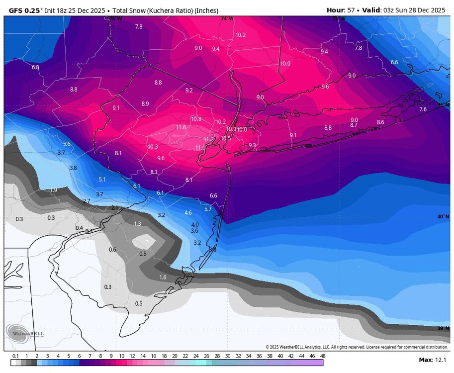
Gfs is 6-10 for NYC
-

Central PA Winter 25/26 Discussion and Obs
Jns2183 replied to MAG5035's topic in Upstate New York/Pennsylvania
Oh boy oh boy. Look.at that jet coming down from deep artic. Sent from my SM-S731U using Tapatalk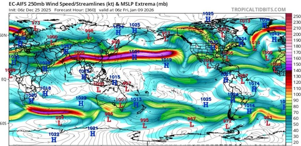
-
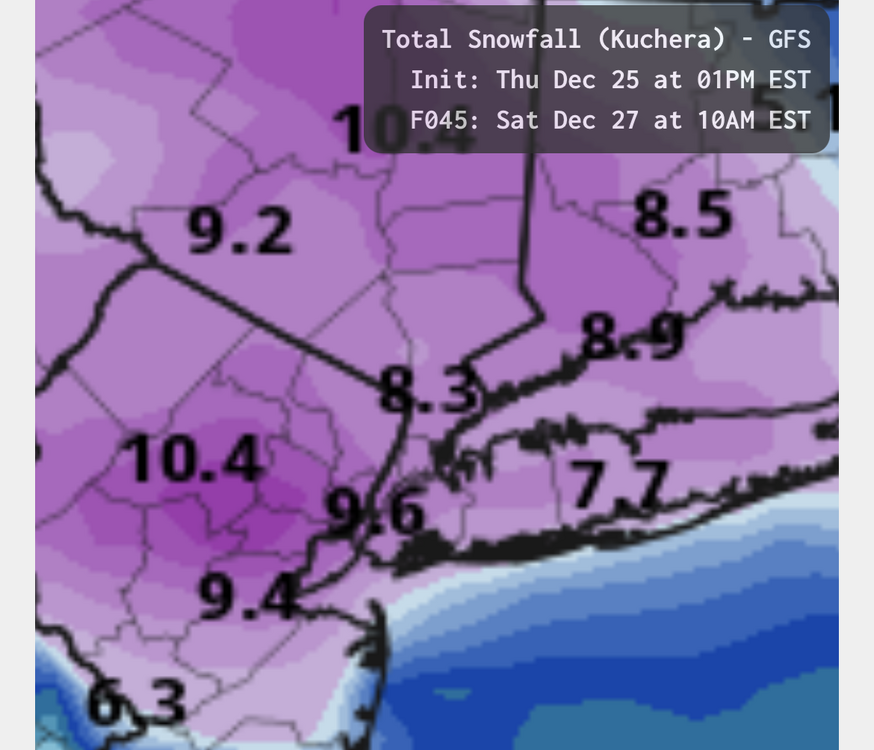
Tomorrow will see increasing clouds. Snow will arrive during the late afternoon or evening and continue overnight. The snow could fall moderately to even heavily for a time. Sleet or freezing rain could mix in toward the end of the storm in parts of the region. A general 4"-8" snowfall is likely in and around the New York City area. Through 18z, a 4"-8" snowfall in and around New York City remains the baseline scenario. The NBM (19z: 8.0") and 76.8% of the EPS/GEFS ensemble members show 4.0" or more snow for New York City while 8.5% show 2" or less. The RRFS A, the NAM's successor, which had been a southern outlier yesterday has stabilized today with snowfall focused on the New York City area and Hudson Valley. Both the 18z RGEM and GFS also focused the snowfall in the consensus area. The 18z NAM is a northern outlier that is largely on its own. Almost always, the skillful models fare better than the NAM when the NAM is largely on its own. Areas to the south and west of New York City will see a larger share of precipitation fall as sleet and/or freezing rain. As a result from central New Jersey southward, snow accumulations will be noticeably lower. Philadelphia could pick up a coating to 2" of mainly sleet. The storm will be followed by a chilly weekend. A storm cutting to the Great Lakes could bring some rain and milder weather on Monday before cold air returns to close out December. The closing days of December will likely be colder than normal. December 2025 will very likely finish with a maximum monthly temperature below 60° in New York City. The last time that happened was in 2019 when the monthly high was 58°. If 2025 has a monthly high below 60°, that would be only the fifth such occurrence since 2000 (2003, 2004, 2005, and 2019 are the cases since 2000). The ENSO Region 1+2 anomaly was -0.6°C and the Region 3.4 anomaly was -0.8°C for the week centered around December 17. For the past six weeks, the ENSO Region 1+2 anomaly has averaged -0.40°C and the ENSO Region 3.4 anomaly has averaged -0.68°C. La Niña conditions will likely continue through at least mid-winter. The SOI was -2.96 today. The preliminary Arctic Oscillation (AO) was +0.775 today. Based on sensitivity analysis applied to the latest guidance, there is an implied near 100% probability that New York City will have a cooler than normal December (1991-2020 normal). December will likely finish with a mean temperature near 33.9° (5.2° below normal). That will make December 2025 the coldest December since 2010 when the monthly mean temperature was 32.8°. It would also make 2025 the third coldest December since 2000. Supplemental Information: The projected mean would be 3.5° below the 1981-2010 normal monthly value.
-
Gfs is coming in south of 12z
-

26th-27th event, coming at us like a wounded duck.
Sey-Mour Snow replied to Go Kart Mozart's topic in New England
Nov 2018 was 6-8” in like a 3-4 hour window off WAA -
26th-27th event, coming at us like a wounded duck.
Sey-Mour Snow replied to Go Kart Mozart's topic in New England
That’s been the thought for a while .. I think 3-6” with the meaty band then maybe 1-3” on either side of that .. -
Here is the 30day map. There are several good time frames in here which are washed out - day 7 increments have those. Really, there is a window between, Jan6-20. The graphic above(from me) makes it look like we have to wait until week 3. No, the good window is now on today's 12z EPS run(not the Weeklies). I wanted to add this one so you all can see where the NAO is centered...right over the Davis Straits. @Golf757075, there it is. Let's see if it verifies. There is another window to start February. Now, that is shades of 95-96 IMHO. To get off to a good start, we need a cold front on Jan 2 and/or 5th to score w/ getting cold into the forum area. Cold in place almost always is our best way forward. I kind of wanted to make sure the past day or two of weeklies runs weren't one-offs...before commenting. But still, proceed at your own risk. Models have been absolutely treacherous at this range.
-

26th-27th event, coming at us like a wounded duck.
Hoth replied to Go Kart Mozart's topic in New England
Just be thankful for every flake man. They’ve been hard won. -

26th-27th event, coming at us like a wounded duck.
ORH_wxman replied to Go Kart Mozart's topic in New England
It’s probably true. Heavy snow for 3 hours is going to give you like a quick 4-5” and then you grab a couple on either side of it, there’s your warning event. People shouldn’t be expecting double digits in this. They might happen, but probably because banding was even stronger than anticipated and you never know quite where the best bands will set up. -

26th-27th event, coming at us like a wounded duck.
Brian5671 replied to Go Kart Mozart's topic in New England
Probably get 3~4 quick inches with that then maybe another 1-2 -

Snow Potential Dec 26-27
CPcantmeasuresnow replied to WeatherGeek2025's topic in New York City Metro
That's probably denial speaking. I'm concerned and I'm 50 miles north of the city. -

26th-27th event, coming at us like a wounded duck.
OrangeCTWX replied to Go Kart Mozart's topic in New England
A little concerned about how quickly the heavy stuff moves through not going to lie. It could be 2-3 hours of the good stuff and then just light snow after? Maybe I’m just being paranoid lol -
Maybe if it wss consistent but so far its still bouncing around
-
Not every time. It’s been too aggressive in the past. Last Feb’s SWFE it was too aggressive.
-

26th-27th event, coming at us like a wounded duck.
Baroclinic Zone replied to Go Kart Mozart's topic in New England
Quite remarkable how cold the lowest levels are. If we get into that fronto omega than we should do fine but otherwise it’s as you said. Virga. -
That has no correlation. NYC cashing in on a snowstorm doesn't mean everyone is going to win come January. For all we know, DC could end up with a final season snow total of 3-4" (see below). That season had one of the oddest snow distributions ever. Places in upstate NY finished the season with over 150 inches of snow, while places like Baltimore and DC finished with less than 4 inches of snow.
-
NAM will be vindicated on this one. Happens every time
-
@John1122, I am not sure I trust the Euro Weeklies right now, but as @GaWxnoted...pretty big changes in the week 3-5 range. Basically, the pattern just is wash...rinse...repeat. NAO/Aleutian high -> NAO/+PNA...over and over. This is week 3, and would be awesome to have for peak climatology.
-
Prison?
-
That depends on where you were. Places well north and west of the city did get a heavy snow event with this one. Allentown had 17”. Places in upstate NY measured into the feet.