All Activity
- Past hour
-

Is we back? February discussion thread
40/70 Benchmark replied to mahk_webstah's topic in New England
It's about normal here, and soon to be below. -
It was 3 here this morning
-
30.8”, Commack NY
-
 -4/-10 at PWS and ASOS is right there too… another frigid evening. During the warmest part of the week. METAR KMVL 030320Z AUTO 00000KT 10SM CLR M20/M23 A3006
-
For the entire winter yes but ytd average is around 14" with the halfway mark being February 5th
-
And one final note, you never want to bet against a jet extension. I have a feeling that is being undermodeled and is probably stronger than expected. Remember in January the thaw was stronger than expected. I wouldn’t be surprised to see that here as well
-

Central PA Winter 25/26 Discussion and Obs
Jns2183 replied to MAG5035's topic in Upstate New York/Pennsylvania
I was diagnosed with that in high School after passing out cold during a sporting event. Tell me, did you get to enjoy the fun test they use to diagnose it? The lovely one where they strap you to a table crucifixion style, jam IV in both arms, pump you full of adrenaline, tilt you and see what happens? I don't think I'll ever forget that test!! Sent from my SM-S731U using Tapatalk -

Richmond Metro/Hampton Roads Area Discussion
ORFDawg2013 replied to RIC Airport's topic in Mid Atlantic
-
I feel for the people in the screw zone, but at least some still had a sense of humor. Van Denton of WGHP asked people to send in the amount of snow along with their location. A lot sent in pictures of a measuring tool in the snow to visually give their amount. A Triad person had his Wake County brother take a picture which he submitted for him.
.jpg.928da4b56722a2ee3df786942c2501d1.jpg)
-
I would expext that; especially because layer in the season La Nina’s tend to be warm for our area. Thankfully most areas have above average snowfall relative to average for this part of the season; but that will quickly change because our next snow chance will have to wait till mid month or beyond. March 2015, March 2018, March 2014 (for southern posters), and March 2023 (for nothern posters) are pretty rare. It would be hard to bet against warm and dry (seems to be the base state for March in the 2020s).
-

2025-2026 ENSO
PositiveEPOEnjoyer replied to 40/70 Benchmark's topic in Weather Forecasting and Discussion
The AI GFS has 60s for Chicago as early as Feb 9. Probably overdone, but 50s aren’t out of the question. A lot of it hinges on the extent of the high latitude blocking -
Anyone have the weather next from 8 pm?
-

February 2026 OBS & Discussion
donsutherland1 replied to Stormlover74's topic in New York City Metro
Through today, cumulative snow depth is 83” in NYC. That’s the highest since 2015-16. -
.thumb.jpg.a628c2147efdff1c820341d5143d9237.jpg) KChuck changed their profile photo
KChuck changed their profile photo -
Eh
-
During any Nina, eventually the late winter warmup arrives. We'll see if this new strat warming can make for a colder March like in 2018, but in any Nina here the clock is always ticking to get our snow in Dec or Jan. Last year we had a decent Feb SWFE, 2018 had the epic March. We'll see what happens.
-
2025-2026 ENSO
PositiveEPOEnjoyer replied to 40/70 Benchmark's topic in Weather Forecasting and Discussion
GFS ensembles are quite warm for the first week of March. Long ways out, but still interesting to see.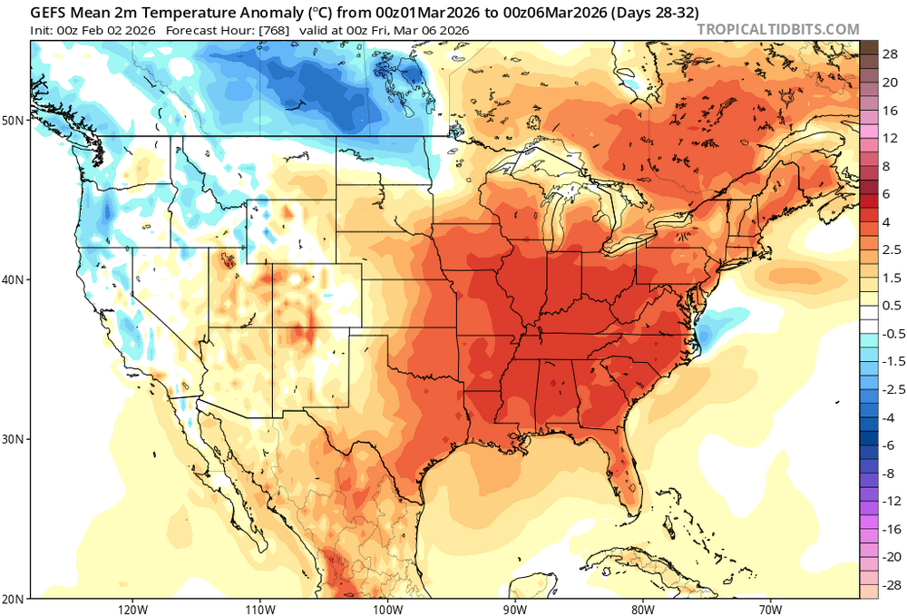
-
36 today. Felt great
-
We were looking at Puerto Rico or the USVI. But then the reality of us wanting to do new flooring made us put the hold on.
-
And the pattern regression once the warm-up comes around the 10th or 11th is quite remarkable. Last week it was looking like wall to wall cold during the month of February with some chances here and there for snow but now it’s going to be bone dry until the middle of the month. And at that point, the temperatures aren’t as cold as they have been and we might run into some temperature issues. And even if we stay relatively near average, the rest of the US will be torching similar to the late December through early January pattern. Overall, very bad trends this week.
-
-
The late Dec event ended up on the low end of expectations here despite no sleet and of course 1/25 there was plenty of sleet here too. Suppression sucks and the lack of real opportunity for snow going forward sucks too but we've at least capitalized on a good window during cold enough air and got the snow to stick around. The last three good for shit winters couldn't make that happen. Probably the best we can ask for until the perma-Nina, warm western tropical Pacific regime changes. Honestly today felt great outside for a change and I'll welcome a warm period if it won't snow. Maybe end of Feb or March will bring more snow chances. We know how March 2018 turned out-not expecting that again of course but maybe one or two decent snow events before the end.
-
Wild that we are under average for the year. In terms of impact, this winter has been way above average. The snow not has not melted for 2+ weeks so it feels like a heavy snow winter even though its statistically not (Especially so if you live in a city and have to park on the street) Are there historical records for total snow depth added up daily over a winter? I wonder where this winter stands.
-

Richmond Metro/Hampton Roads Area Discussion
wasnow215 replied to RIC Airport's topic in Mid Atlantic
That LP develops well on that run -
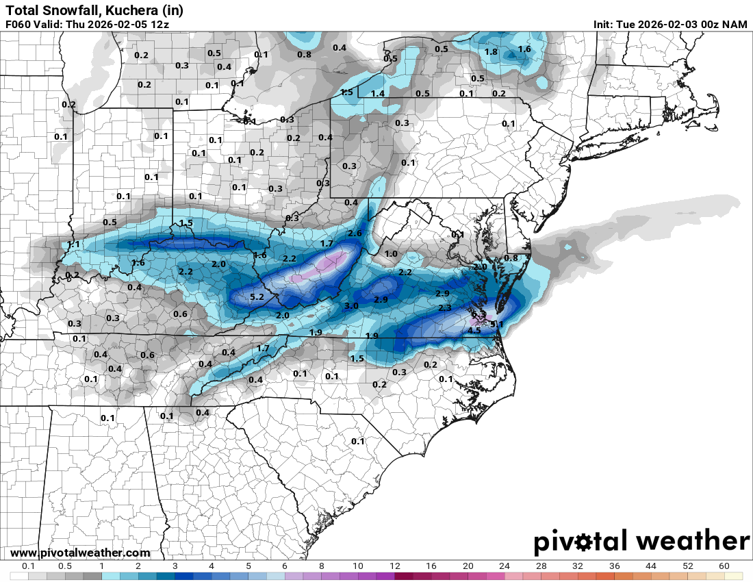
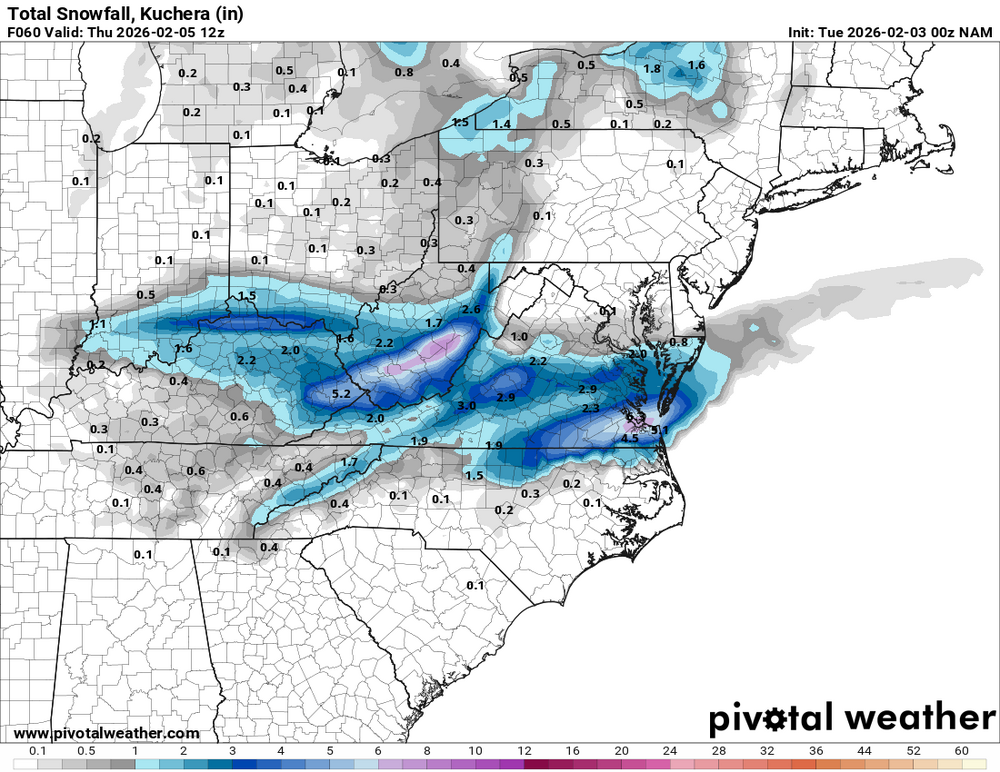
HRRR only goes out to 7PM Wednesday night but has a little snow. Both the NAM3K and HRRR did well with the last system. Nam3k is a little wintry mix but mostly north of wake
-
Even a few 1" refreshers would have gone a long way during this period. This winter has clearly been better than the last several, but the two sleet events have tainted the vibe in NJ relative to areas east (NYC/LI) and north (LHV).