All Activity
- Past hour
-
Ur fukt up It's 90 here. My dumbass mowed the lawn. It looks pretty good
-
90 at several nearby PWS. Oh yeah baby.
-
Just hit 90 a little while ago.
-
86.5 a downslope dandy.
-
That's the big heavy pollen which isn't nearly as troublesome as the microscopic pollen that gets into nasal cavities.
-
I think that happened in the Napril heatwave too.
-
We was moving yesterday,moving from Brentwood to Franklin Tn i assume this was yesterday?It wasnt here..lol
-
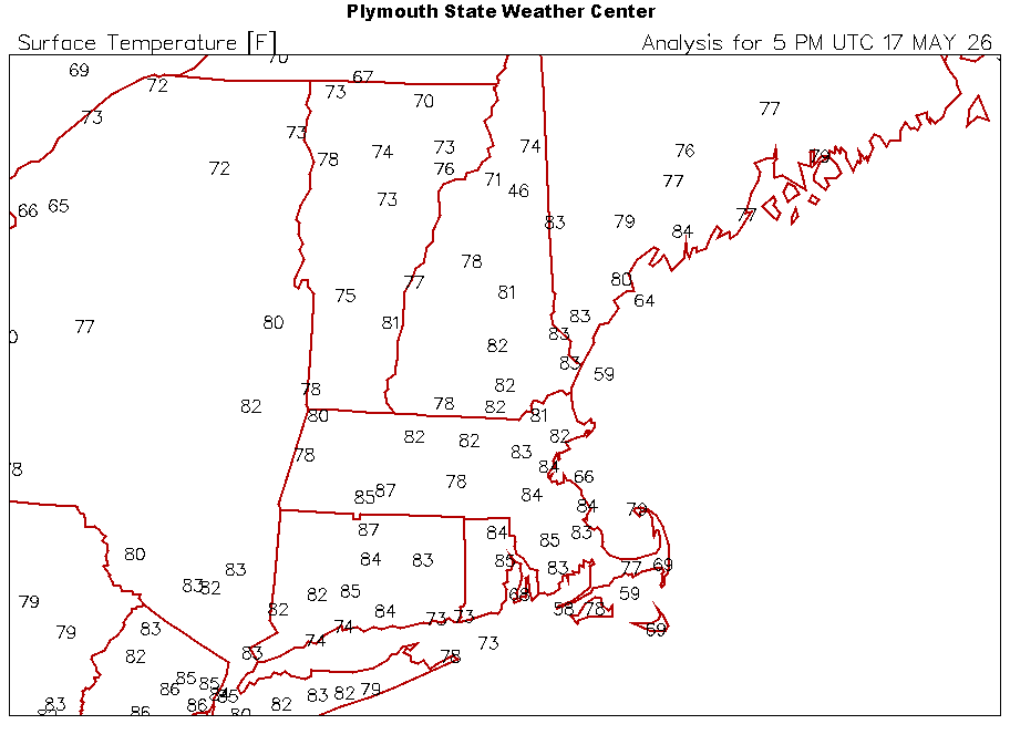
87
-
There’s a pretty good conditional risk for any cells that pop up near the warm front over central Lower Michigan the next few hours. A few cells already trying to go.
-
Made it to my first 30C reading of the year, forecast 25, then 27, my hope was 29 . Overnight low of 19 will be higher than most days' highs during the last 3 weeks. The nightmare is over.
-
I think they did it. Twice they had 3 straight obs of 32C. I’d bet they snuck a 32.2 in there.
-
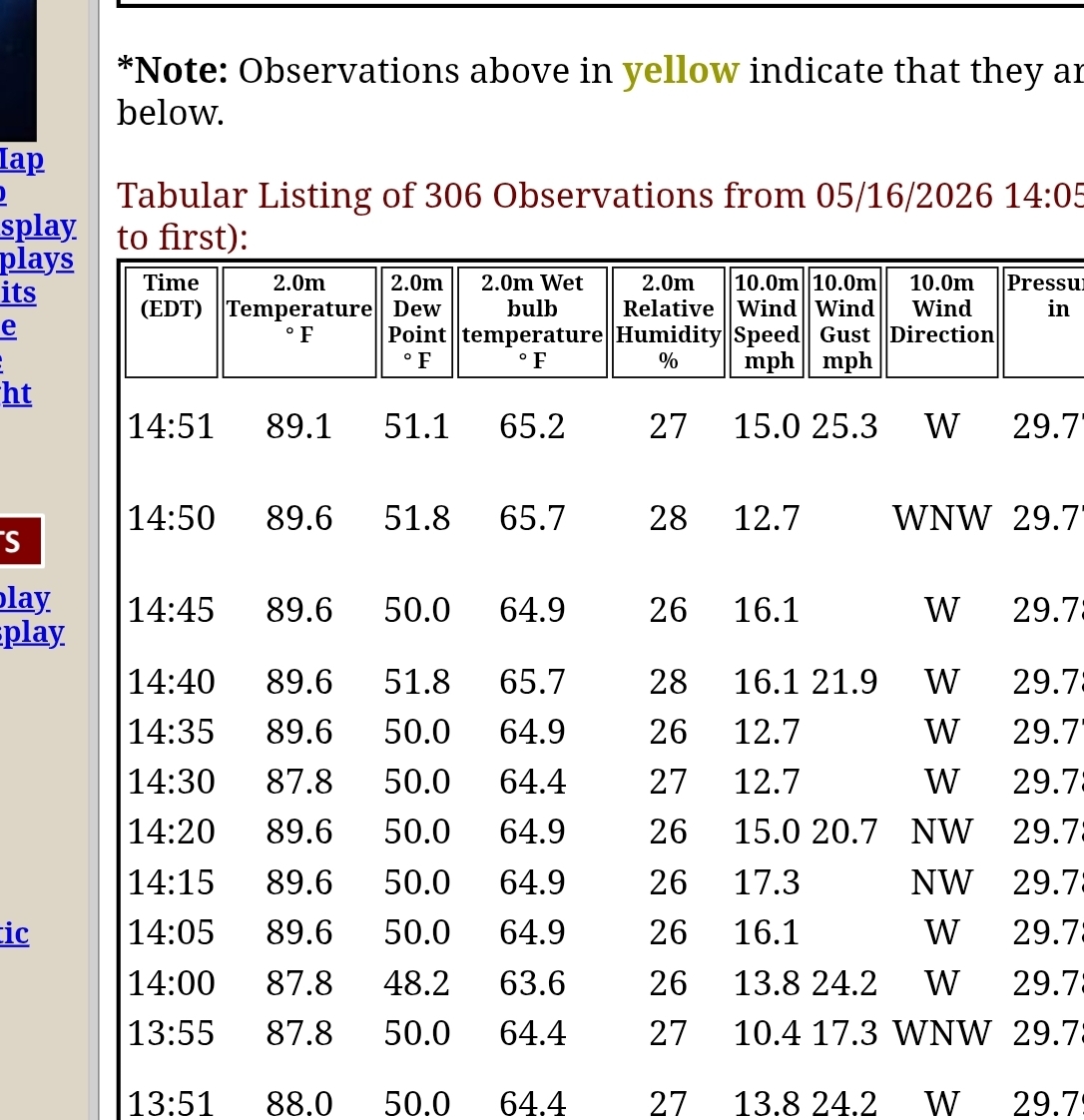
Looks like 89.6. But I'm sure Dendrite will chime in that its some Celsius conversion thats not valid... haha

-
86 with a dewpoint of 52 feels chilly..
-
Think BDL hit 90. Possibly 91. Hard to tell
-
Not allergic to anything plant wise so i never have allergies. But this is the first spring that nothing was coated in green pollen from all the trees.
- Today
-
90 in Orlando w/DP of 68 currently. Summer weather down here. Bringing the heat back with me the middle of the week.
-
90
-
88-89F
-
Look on the bright side. We are only about 30 days away from the latest sunset and then we will SLOWLY start going the other way. The hole is almost dug and we will soon starting filling it in.
-
Ask and you got it.
-
86 here Yuck
-
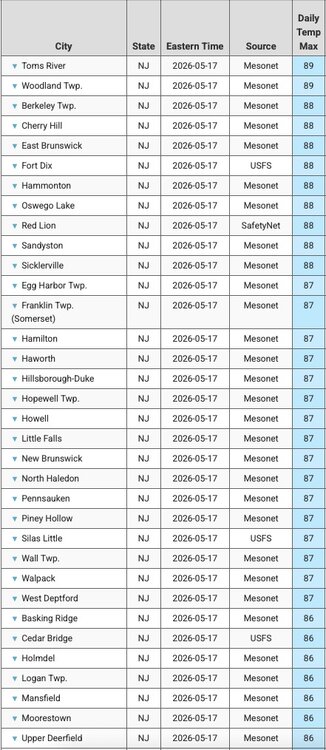
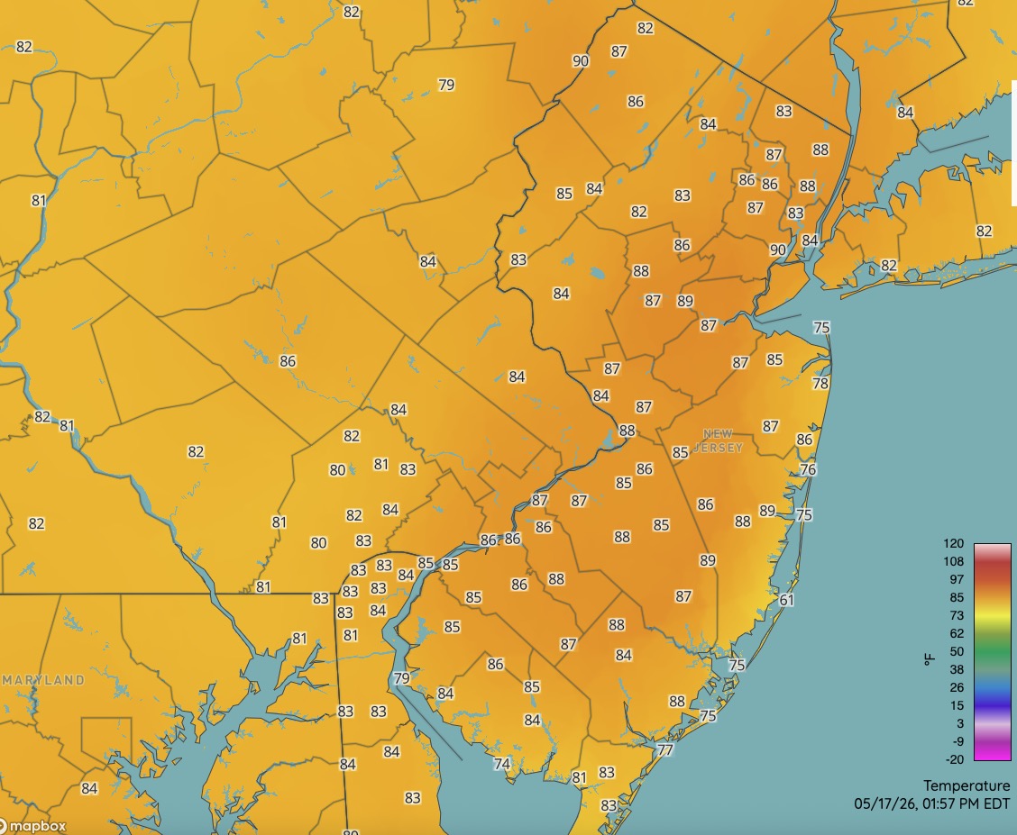
Some of the NJ hot spots are flirting with 90 degrees this afternoon. NJ April climate summary: https://www.njweather.org/content/thermal-whiplash-april-2026-recap-and-20252026-snow-season-overview

-
Looks like BDL is going to put up a 90...
.thumb.png.c9d0f46fcdda4b73d3809cb958bec4bf.png)
-
NAM is BDing NE/E coastal zones tomorrow. Not sure I'm surprised or think that's necessarily wrong given to the fact that this extended arm of the warm boundary is actually a stationary boundary with a slightly elevated +PP in the GOM. The deep layer wants to erode it back NE as it comes but given to the positive static stability/density argument, it's not unfounded to have that get into the 495 region ... It may also collapse back E and send the old 6:15 pm high temperature to Logan as an outside shot too. West of 495 looks quite warm. Tuesday has 30C in the T1 layer of the NAM grid on a WSW flow, 850s of 17+C and < 60% ceiling RH ... that's a hugely above normal day for this time of year. Probable 2m Ts in the 94 range ...tickling big heat numbers. Newark NJ/metro west of NYC get it done on this run
-
CRV baking


.png.53327c72bf47d90adcfb0795535eff37.png)