All Activity
- Past hour
-
Beer
-
Today is going to be the hottest day out of the bunch most likely. Oppressive out there with a current dew point of 79. Good call on the expanded heat advisory from LOT
-
Tropical Storm Edouard Discussion Number 5 NWS National Hurricane Center Miami FL AL052026 1000 AM CDT Tue Sep 01 2026 Edouard is a small but strengthening tropical storm. The center has been trackable this morning using NWS radar data from Lake Charles, Louisiana (KLCH), and recent data show the inner-core structure of the system is becoming better organized. There has been a notable increase in deep convection near and to the south of the center, and a recent dropsonde released in that area reported mean boundary layer winds of 61 kt. Doppler velocities have also notably strengthened during the past couple of hours, and adjusting these data to estimate a surface wind support raising the initial intensity to 45 kt. The last center dropsonde from the Air Force Hurricane Hunters showed the central pressure has fallen to 1000 mb. Environmental and oceanic conditions are conducive for additional strengthening for as long as the center remains offshore. With very warm Gulf waters and weak vertical wind shear, the hurricane regional models continue to highlight the potential for continued strengthening through landfall. The 12-h forecast point for Edouard is well inland, but note that additional strengthening is expected that cannot be easily reflected in the official forecast. A Tropical Storm Warning and Hurricane Watch remain in effect for portions of the Upper Texas coast and southwestern Louisiana. Given the improved radar structure of Edouard and the expectation of additional strengthening, NHC will issue hourly Tropical Cyclone Updates (TCU) beginning at 1100 am CDT (16 UTC). Once inland, Edouard is likely to rapidly weaken and should dissipate on Wednesday. Some short-term wobbles have been observed in radar data during the past few hours, but the longer-term motion of Edouard is northwestward (305/7 kt). This general motion is expected to continue through tonight, which will bring the center of Edouard onshore near the Texas/Louisiana border within the warning area this afternoon and then inland across southeastern Texas tonight. The updated NHC track forecast lies slightly to the right of the previous prediction based on the latest consensus trends. Key Messages: 1. Edouard is strengthening as it approaches the northwest Gulf Coast, and tropical storm conditions are beginning along the southwestern Louisiana and Upper Texas coasts. Hurricane conditions, especially in gusts, are still possible from High Island to Cameron later today. 2. A Storm Surge Warning is in effect along the immediate coast from High Island, Texas, to the Vermilion/Cameron Parish Line, Louisiana, where peak values of 3 to 5 feet above ground level are possible. 3. Heavy rain will impact parts of the Upper Texas coast through east-central Texas into far Southwest Louisiana today and Wednesday as Edouard tracks inland. Flash flooding is likely across this region, especially in urban areas. River flooding may also be possible. FORECAST POSITIONS AND MAX WINDS INIT 01/1500Z 29.4N 93.3W 45 KT 50 MPH 12H 02/0000Z 30.2N 94.2W 40 KT 45 MPH...INLAND 24H 02/1200Z 31.2N 95.2W 25 KT 30 MPH...POST-TROP/INLAND 36H 03/0000Z...DISSIPATED $$ Forecaster Reinhart
-
-
Not much to add for me. Edouard is running out of time but is trying to make a run this morning.
-

Mountain West Discussion
mayjawintastawm replied to mayjawintastawm's topic in Central/Western States
August rain at my house=2.25". Was hoping for a bit more to end the month and it rained the last 4 days in a row but with a whopping total of 0.09". It's pretty uncommon to get monsoon moisture here after Labor Day but we'll see.... -
Not playing devil's advocate, but it was a small core to begin with. I don't think it needed tightening so much as it just needed an intense inner band to erupt in close proximity to the nascent LLC. Once that happens, it's better able to absorb/feed off of the high immediately high SSTs. It's essentially a feedbak loop. You need a strong cell to wrap and increase that inflow into the updraft, hence what we are seeing now. Sure, it doesn't hurt to be near the shoreline and moving over high heat content.
-
I like my months to be 4 letters or less
-
I'm wall to wall blowtorch. Deep South severe all winter. Early season start to severe Mid-South. Of course the eastern Valley will find a way to be cool. Great for storm anxious, but just one more thing about which I will vent!
-
Unfortunately I believe that Carvers is right. I know we've had some warm Septembers, but this is effin' ludicrous! I can handle a couple ridiculous weeks, but the whole month looks ludicrous. And this week is effin' plaid! (Spaceballs)
-
Took me a second and I never thought about it: September, October, November, December. It's a great time, if the weather cooperates.
-
Took the words right out of my mouth. The quick wrapping of the core has me thinking HU intensity is not off the table yet.
-
Good because I am in Soup mode!
-
Might be starting to see some of that frictional convergence at play now with the tightening core
-
What is BER?
-

Occasional Thoughts on Climate Change
WolfStock1 replied to donsutherland1's topic in Climate Change
Why do you say that? Theoretically AGW could have actually *delayed* this collapse. (devil's advocate - bear with me) If we go with the freeze/thaw loosening theory (seems quite plausible, at least as a contributing factor): From what I read - there can be some freeze/thaw cycles that happen underneath glaciers, due to some cyclical nature of their movement; they accelerate and decelerate some with the seasons; the changes in friction then resulting in some temperature swings. In some cases I would imagine there are glaciers for which the ground (bedrock etc.) underneath is typically thawed more frequently than it is frozen. In some areas in such cases an overall increase in atmospheric temperature can result in *less* freeze/thaw cycling, rather than more. This can be true on the surface, but could also even be more true at depths due to dampening of the atmospheric effect. An increase in freeze-thaw cycles would actually only actually happen at places that are specifically on the thresholds where for any given season the ground under the glacier sometimes - but not always - thaws in any given season, and where the thawed period is less than the melted period. In general - it seems like folks are doing their damndest to try and pin any and all natural disasters on AGW, when mostly they're likely just, well, natural, and would have happened whether AGW was a thing or not. -
Improvement on IR imagery is remarkable over just the last 2 hours
-

Septorcher 2026 Discussion - Endless Summer
SouthCoastMA replied to Damage In Tolland's topic in New England
ground not even wet. blows -
90+ through Saturday here.
-
0.96" overnight, more than i expected. Heavy showers moving in, just heard a rumble of thunder
-
There is still a weaker component to the northern semicircle of the overall vortex, but compared to even three hours ago, this is a very significant improvement in core presentation.
-

Septorcher 2026 Discussion - Endless Summer
CoastalWx replied to Damage In Tolland's topic in New England
Probably will be rain -

2026-2027 Record-breaking El Nino
bluewave replied to Stormchaserchuck1's topic in Weather Forecasting and Discussion
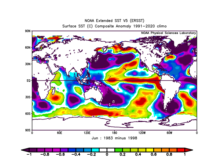
I think part of what saved February in 1983 was Nino 1+2 didn’t peak until the summer and wasn’t as extreme as 1997-1998 was during the winter.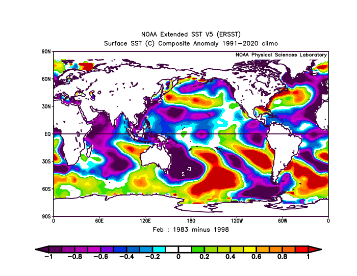
-

Septorcher 2026 Discussion - Endless Summer
dendrite replied to Damage In Tolland's topic in New England
He looked upon what he did and it was indeed very good
-
I think that being open-minded about this is the best approach at this time. I initially assumed that CC was the main cause of this. Now, after reading about the bedrock collapse theory put out by a reputable publication (per my checking into it this morning), that’s giving me some doubt about my first thoughts. I just posted this elsewhere: “I’ve also been reading about the theory about the main cause of this being bedrock failure with the glacier collapsing mainly because of that. Whereas CC could easily still have played some role, there are currently more doubts in my mind than earlier as regards whether it played a large role based on what I’ve been reading today. In summary, much more time is likely needed to attempt to figure out the actually cause(s) of this complex disaster. That’s the safest approach to take now. Even if CC didn’t play much of a role in this, that in itself doesn’t minimize the effect of it on melting ice in general due to GW.”