All Activity
- Past hour
-
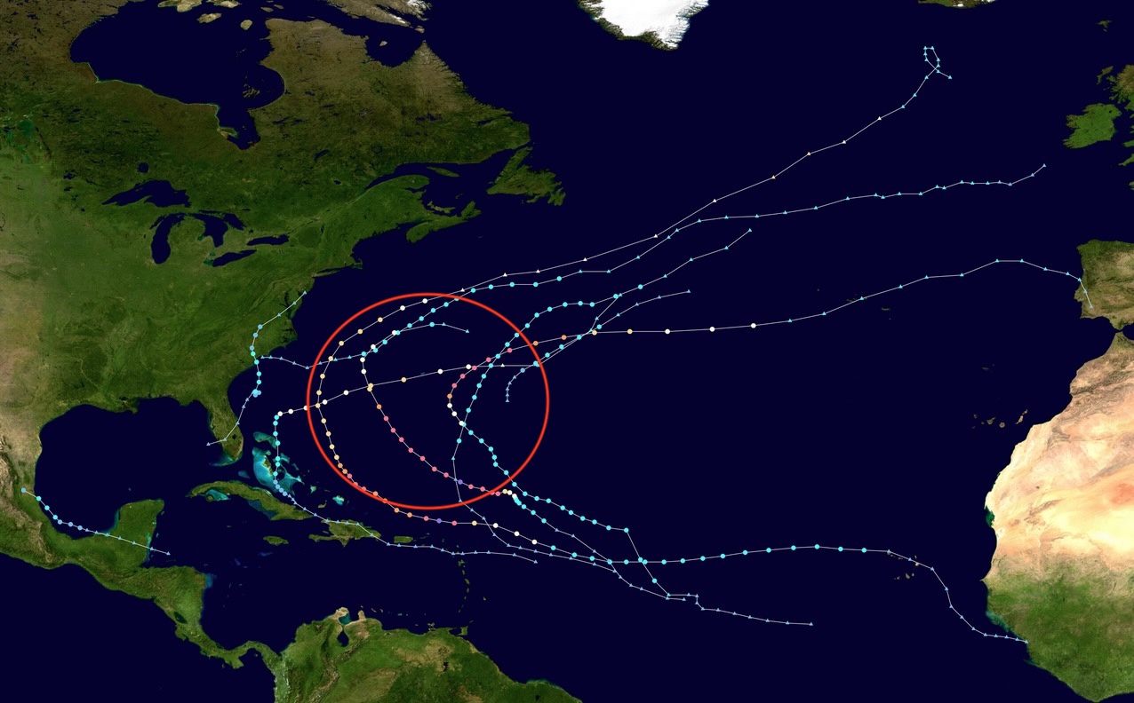
Thanks for clarifying. Regarding MDR activity, 2025 sort of reminds me of a quieter version of these 3 years of the current active era that had all MDR TC origins recurve safely from the Conus: 1995: from MDR like Erin in 2025 only one was close (Emily); was also La Niña 2010: from MDR like Erin in 2025 only one was close (Earl); was also La Nina 2023: from MDR like Erin in 2025 only one was close (Lee) and similar to 2014: from MDR like Erin in 2025 only one was close (Bertha)
-
CANSIPS and CFS Monthly runs continue to look like a favorable pattern for DJFM. Ridges in the west, below normal cold in Canada, etc. That's all you can ask for at this time range.
-
It was in the low to mid 70s in the western UP at 530am. That would be incredible warmth in July at that time of night let alone early October.

-

Eastern Atlantic Orange 60% chance
NorthHillsWx replied to bigtenfan's topic in Tropical Headquarters
And pretty much all of this seasons ACE comes from your circle -
Eastern Atlantic Orange 60% chance
NorthHillsWx replied to bigtenfan's topic in Tropical Headquarters
It’s been a strange season but one thing that has held up was the idea of the SW Atlantic producing. Record high OHC translated into an epic season for that specific part of the basin -
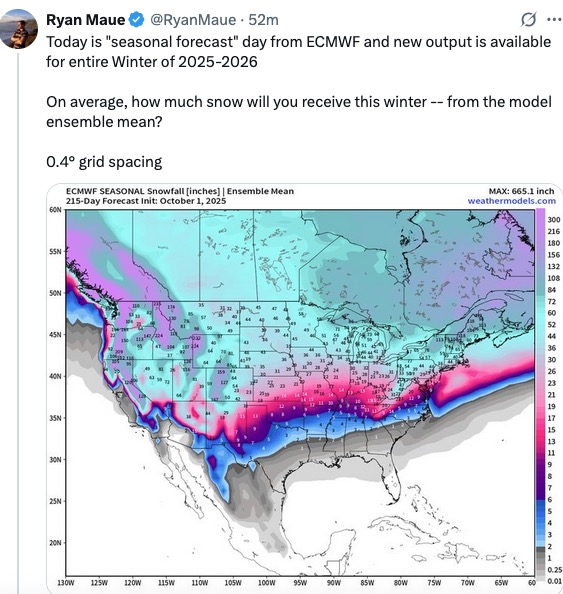
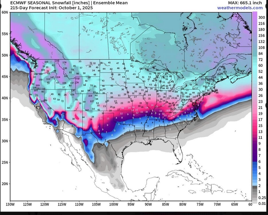
Something to keep you cool on an unseasonably warm October day. From Dr. Maue X post. Covers the full upcoming winter season. Buckle up ! I'd bet on the under myself.
-

Spooky Season (October Disco Thread)
Snowcrazed71 replied to Prismshine Productions's topic in New England
Not a couple of showers. The Euro shows a half inch to 1 in and the GFS shows about an inch. We need the rain desperately and that's welcomed precipitation. -
80 / 55 warm startr
- Today
-
We've had recent winters where the pattern wasn't the problem, it was just too warm.
-
Humidity creeping up. Still a billion mosquitoes in my yard.
-
Followup to above post: Followup: rain became moderate to even heavy at times and more continuous the last few hours including some heavy rain in a thunderstorm a little while ago. But so far there’s been no flooding in my location as the totals appear to be no more than 1” so far. Now the precip. elements are moving more SE to NW.This FFW was released, mainly for N and W parts of my county as my area hasn’t had the 2-3” referenced:BULLETIN - EAS ACTIVATION REQUESTED FLASH FLOOD WARNING NATIONAL WEATHER SERVICE CHARLESTON SC 1121 AM EDT SUN OCT 5 2025 THE NATIONAL WEATHER SERVICE IN CHARLESTON HAS ISSUED A * FLASH FLOOD WARNING FOR... CHATHAM COUNTY IN SOUTHEASTERN GEORGIA... * UNTIL 215 PM EDT. * AT 1121 AM EDT, DOPPLER RADAR INDICATED THUNDERSTORMS PRODUCING HEAVY RAIN ACROSS THE WARNED AREA. BETWEEN 2 AND 3 INCHES OF RAIN HAVE FALLEN. FLASH FLOODING IS ONGOING OR EXPECTED TO BEGIN SHORTLY. HAZARD...FLASH FLOODING CAUSED BY THUNDERSTORMS. SOURCE...RADAR INDICATED. IMPACT...FLASH FLOODING OF SMALL CREEKS AND STREAMS, URBAN AREAS, HIGHWAYS, STREETS AND UNDERPASSES AS WELL AS OTHER POOR DRAINAGE AND LOW-LYING AREAS. * SOME LOCATIONS THAT WILL EXPERIENCE FLASH FLOODING INCLUDE... POOLER, I-16/I-95 INTERCHANGE, SAVANNAH INTERNATIONAL AIRPORT, GODLEY STATION, HUNTER ARMY AIRFIELD, DOWNTOWN SAVANNAH, GARDEN CITY, PORT WENTWORTH, BLOOMINGDALE AND MEINHARD. VERY HEAVY RAINFALL IS OCCURRING ACROSS NORTHERN CHATHAM COUNTY. THE SAVANNAH INTERNATIONAL AIRPORT MEASURED 1.53 INCHES IN AN HOUR AND OTHER AUTOMATED RAIN GAUGES IN THE AREA HAVE MEASURED NEARLY 3 INCHES OF RAIN SO FAR TODAY.
-

2025-2026 ENSO
40/70 Benchmark replied to 40/70 Benchmark's topic in Weather Forecasting and Discussion
My point is I'm not convinced we won't see that again. If anything, it's been more common the last 30 years...we just did it 11 years ago. What was the return rate on it pre 1994? We don't know because it had never happened. -
Sorry, maybe I should have been more clear. Was referencing MDR stuff with persistent re-curvature. Nothing from MDR has presented with a U.S. landfall threat. Erin was 200 miles away but only the notable large size and intensity made it more impactful than it would have been. Still the fact is all MDR action has re-curved OTS. Chantal was a home brew deal. I was strictly referring to MDR activity in my post.

-

Central PA Fall Discussions and Obs
canderson replied to ChescoWx's topic in Upstate New York/Pennsylvania
Sark’s not going anywhere after back to back playoff runs. And Franklin has a $56m buyout. He’s not being fired - they can’t afford it. -
Yeah, I have been pointing this out about March in recent years. The whole area near the coast has seen the lowest March decadal snowfall on record since 2020. The complete opposite of the 2010s. March Monthly Total Snowfall for NY CITY CENTRAL PARK, NY Click column heading to sort ascending, click again to sort descending. Mean 0.1 0.1 2025 0.0 0.0 2024 T T 2023 0.1 0.1 2022 0.4 0.4 2021 T T 2020 T T March Monthly Total Snowfall for NY CITY CENTRAL PARK, NY Click column heading to sort ascending, click again to sort descending. Mean 6.0 6.0 2019 10.4 10.4 2018 11.6 11.6 2017 9.7 9.7 2016 0.9 0.9 2015 18.6 18.6 2014 0.1 0.1 2013 7.3 7.3 2012 0.0 0.0 2011 1.0 1.0 2010 T T March Monthly Total Snowfall for ISLIP-LI MACARTHUR AP, NY Click column heading to sort ascending, click again to sort descending. Mean 0.5 0.5 2025 0.0 0.0 2024 0.0 0.0 2023 1.6 1.6 2022 1.6 1.6 2021 T T 2020 T T March Monthly Total Snowfall for ISLIP-LI MACARTHUR AP, NY Click column heading to sort ascending, click again to sort descending. Mean 8.2 8.2 2019 4.1 4.1 2018 31.9 31.9 2017 7.4 7.4 2016 3.2 3.2 2015 19.7 19.7 2014 5.4 5.4 2013 7.4 7.4 2012 T T 2011 2.1 2.1 2010 0.4 0.4
-
The entire I-95 corridor from DC to Boston has been in the same boat. This has been the lowest 7 year combined snowfall total for this area in recorded history. It’s a function of warmer winters and warmer storm tracks. Past instances with low 7 year snowfall totals like which ended in 1992 were more a function of drier winters and not the record warmth of the last decade. The following years with historic snowfall from 92-93 to 95-96 were during a much colder era which no longer exists. So it’s unlikely without a major volcanic eruption that we see such a strong rebound in snowfall during the reminder of the 2020s. I would be happy just to see even a smaller rebound off these record 7 year lows in at least one of the remaining 2020s winters.
-

Spooky Season (October Disco Thread)
Great Snow 1717 replied to Prismshine Productions's topic in New England
Right up to the beginning of winter on 11/1???????? -
.thumb.png.4150b06c63a21f61052e47a612bf1818.png)
Spooky Season (October Disco Thread)
HIPPYVALLEY replied to Prismshine Productions's topic in New England
Maybe up to .25” for some? Certainly nowhere near enough rain to dent the drought up north. -
This winter is looking more and more like a worst case scenario for mid atlantic up to nyc (not sure about sne that feels borderline right now). Could be another 2022-2023 for these regions.
-
Wow I forgot how march was a full on spring month this year. March has totally ceased to be wintery in recent years, the last march with more than an half an inch of measurable snow in central park was 2019. I actually think this alone is more impressive than the overall warming/ lack of snow trend. March totally is not a winter month at all anymore.
-
We'll see if that comes up to us at all or gets pushed OTS as it moves N.
-

Central PA Fall Discussions and Obs
Jns2183 replied to ChescoWx's topic in Upstate New York/Pennsylvania
Hopefully these next few days are the last 80's of the year Sent from my SM-G970U1 using Tapatalk -
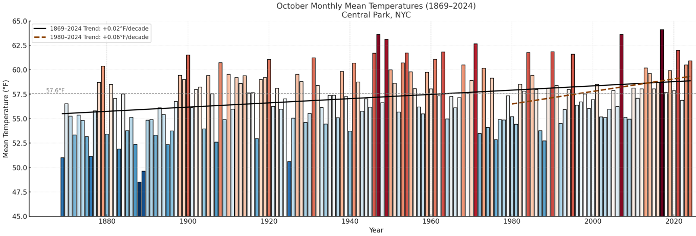
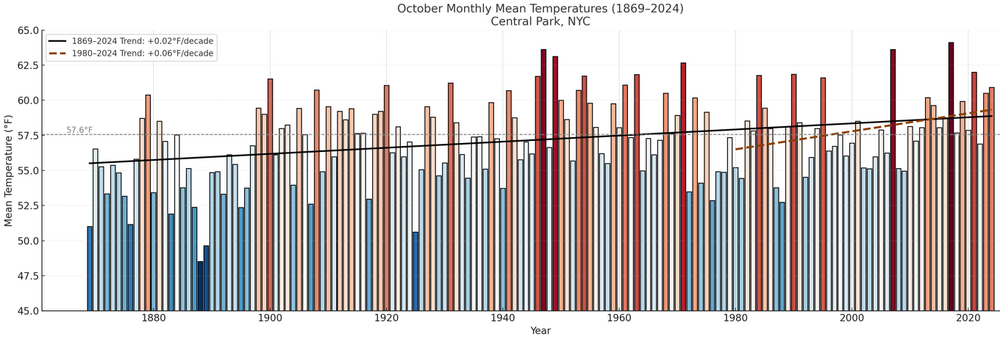
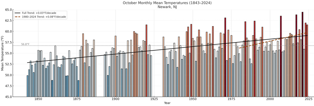
Here's how October has fared in New York City and Newark. The rate of warming has been very gradual, though there has been some acceleration since 1980. The chart's anomalies are based on the 20th century mean temperature for October. For Central Park, the 1991-2020 baseline temperature is 57.9° vs. the 20th century figure of 57.6°. Note: Octobers with large amounts of missing data were excluded.
-
another cutoff under thrb ridge
-

2025-2026 ENSO
donsutherland1 replied to 40/70 Benchmark's topic in Weather Forecasting and Discussion
There were 3 prior cases: 1881-1882, 1889-1890, 1931-1932. 2023-2024 (34.8° was a near miss). Suburbs are cooler. In the larger picture, I don't think Detroit and its vicinity have any worries that winter will essentially become unrecognizable for decades to come.