All Activity
- Past hour
-
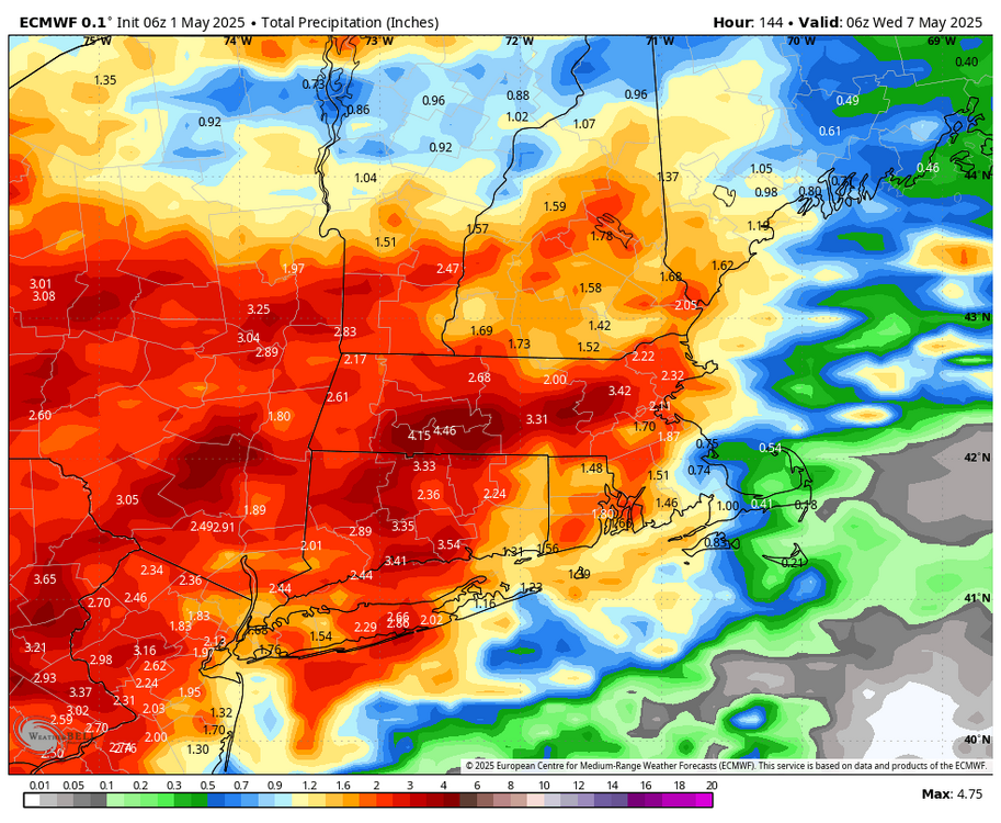
even if the heaviest is west you'll still get 1 to 2 by Wednesday.. Stein dead
-
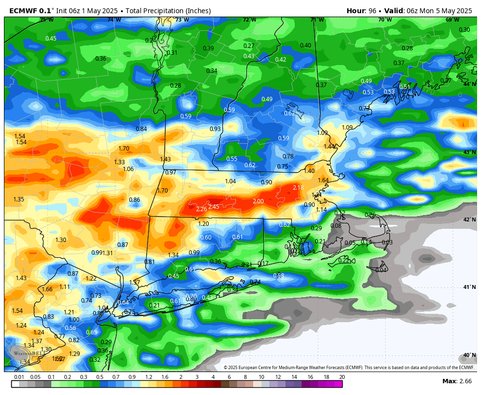
up to 0.79" this morning with more showers throughout the next 2 days.
-
12z NAM seems to back up the 00z globals in showing more to the west of 95 (through 00z monday)
-
Does anyone think the severe risk will shift a little east later today?
-

Central PA Spring 2025
Itstrainingtime replied to canderson's topic in Upstate New York/Pennsylvania
Not really a forecast per se but I haven't forgotten this post. Three wasn't a whole lot of model consensus at the time but everything has come around to it over the past several days. -
The whole thing is way west. You can see the setup. Rain sets up ENY into S VT. Classic look while east Steins
-
Let’s get water flowing out of hillsides in Tolland.
-
This is through 6z Monday. Overall looks Steiny through Tuesday night.

-
It does specify both afternoons as when showers are likely but I think right now it's too difficult to pinpoint
-
Weather.cod has it in better increments
-
Pretty wet even here. Front stalls a bit further south. Not sure I buy it.
-
yeah-most models don't have much at all for Saturday now....
-
Part of the problem with these forecasts is it will say 70% chance of showers Saturday and Sunday but end up raining for a total of 4 or 6 hours. I see lots of cancellations of weekend events already
-
Ugh-that's miserable in the rain-we did it a few years back a few times-one year had off and on shower and cold.
-
if you wait Tropical Tidbits has it just comes out super late https://www.tropicaltidbits.com/analysis/models/?model=ecmwf®ion=us&pkg=mslp_pcpn_frzn&runtime=2025050106&fh=6
-
Hopefully this doesn't become some 2 week long stretch of sprinkles and drizzle that amounts to like .20 like last September.
-
Deets? I'm too cheap to pay for the off hours runs
- Today
-
Either way it's not going to be 5 days straight of rain
-
Not sure how "fine" the weekend looks. Euro (0z) has me gettting close to 1.5" precip by 0z Monday. Some breaks, and I tend to find the maps a bit overdone...
-
Working at the 5 boro bike tour I hope that's true for Sunday. Or at least limited to an occasional light shower.
-
6z euro just laughed at this call.
-
I knew it's been dry in the last few years but dang...in LWX's disco, they mention IAD is down 33" since 2021. It's been absolutely forever since the whole forum gets a soaker. Looks like we'll get something beneficial altho the bullseye is well north.
-
hope to get out and chase!
-
April 2025 continued the warmth, coming in as the 6th warmest April in DC history, with an average temperature of 61.7 at DCA, exceeded only by 2017 (63.8), 2019 (62.4), 1981 and 2023 (62.1), and 1994 (62.0). During last year's recordbreaking warm year in DC, April averaged 60.5 at DCA. However, January-April 2025 at DCA was below last year, at 47.8 vs 49.1. The warmest January-April in DC history was 50.1 at DCA in 2012.
-

Central PA Spring 2025
Mount Joy Snowman replied to canderson's topic in Upstate New York/Pennsylvania
Low of 50. Modeling all coming around to the Euro's idea of a days long period of rain and clouds induced by a hovering ULL next week. Would be great for the grass, ground, trees, and most importantly, shrubbery.


.thumb.JPG.418e8a9a2902ae687ec35ff4bc0e038e.JPG)

