All Activity
- Past hour
-
Okay I didn’t know this. I feel like I had never heard that name before but maybe it replaced a retired name?
-
lol why is the NHC in love with the name Isaias?
-

2026-2027 Record-breaking El Nino
forkyfork replied to Stormchaserchuck1's topic in Weather Forecasting and Discussion
maybe you should get it printed on a teddy bear and cuddle it to sleep every night <3 -
I’m sure there’s someone out there that would take that deal We let each other be ourselves. That works well most of the time. Looks like we have a center reformation ongoing. A vertically aligned system substantially increases RI odds.
-

E PA/NJ/DE Autumn 2026 Obs/Discussion
JTA66 replied to PhiEaglesfan712's topic in Philadelphia Region
I'm mildly surprised they didn't retire the name "Isaias", that was quite an impactful storm. Anyway... Bottomed out at 40F yesterday morning and 39F this morning. -
2026-2027 Record-breaking El Nino
forkyfork replied to Stormchaserchuck1's topic in Weather Forecasting and Discussion
did that 20cm shade of apocalyptic blue give you a wx hardon -
Will caution those who loves the latest CANSIPS pattern. While it looks good for storm track, the heights rising off the East coast give me some pause as we've been burned by a good NAO high pressure linking with the southeastern ridge. Additionally, with temperature anomalies in the Gulf stream being several degrees above average I wonder if the models may underestimate the southeastern ridge. Of course, too far out to draw any real conclusions, but I might favor a further west track than the H5 alone would suggest. Think it might be a big year for the mountains, especially the ridges that will be a few (possibly key) degrees colder. Also think @mitchnick's theory that it will be winter where we might have to be patient and watch a lot of rainstorms that slowly pull the boundary south before we get a limited window to get a follow up wave. That said, I could see a @psuhoffman nightmare situation where we see the boundary be pushed south before getting a perfect track rainstorm with snow confined solely to the high mountains due to just not having enough cold air. By the end of October we should have a better picture as the October NAO negative correlation to winter's NAO is our first real significant one.
-

2026-2027 Record-breaking El Nino
mitchnick replied to Stormchaserchuck1's topic in Weather Forecasting and Discussion
Apparently you did. -
Agreed, it does meet the NWS definition of first frost (low of 36-32) so that's how it goes down in my books. I also track the much more subjective first visible frost, still waiting to log that for me. My average First Frost date is 10/12 so a little early this year.
-
34.7 for the low here. Some frost on the rooftops and grass, first of the season.
-
a low of 38
-
I saw a couple yards on the way into work with some light frost on the lawns but that was it.
-
 https://antibiodirect.shop/# prescribed antibiotics online
 -
PSEG really went to work in my neighborhood after Isaias and some other wind events and trimmed a lot of branches near wires so thankfully in this last storm I just had power flicker a couple times but was good. A few streets away though where they didn’t trim had no power for 2.5 days.
-
Bottomed out at 34.7. Frost on the roofs and many areas of the grass.
-

2026-2027 Record-breaking El Nino
LakePaste25 replied to Stormchaserchuck1's topic in Weather Forecasting and Discussion
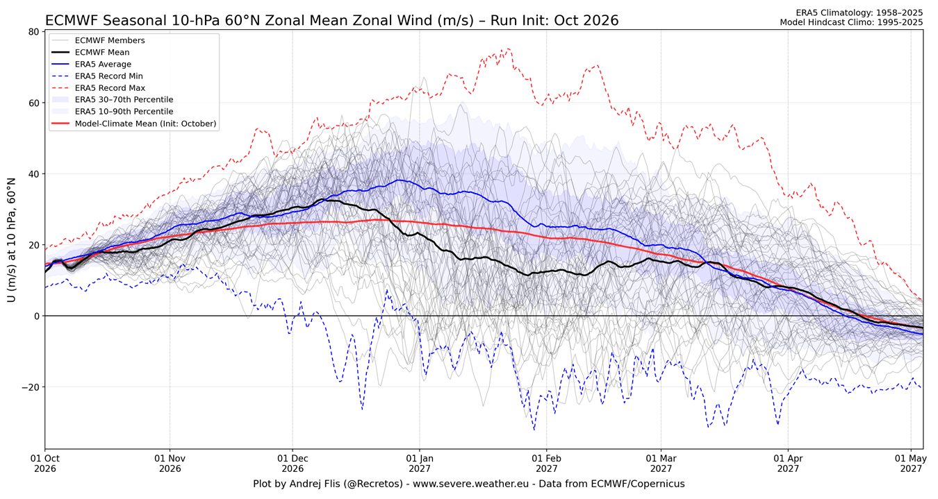
it’s giving you the historical ERA 5 reanalysis average up until 5/1/27. You’ll notice all the lines converge together starting between march and april because a) the PV becomes weaker and less variable by the spring and b) models tend to default to climatology very far out. So the ensemble forecast mean (black) will start to closely match the hindcast climate mean (red) and ERA5 mean (blue) between March and April. Also it’s important to note the red line being lower than the blue line between Dec and March. What that’s telling you is that when the model tried to reconstruct a hindcast of past years, it was forecasting a weaker PV than the actual ERA5 reanalysis. So it’s saying the model has a weak PV bias in its forecasts during the heart of winter. -
Tornado risk could be significant, especially if it landfalls PNS east but overall the impacts on winds should be more in line with Michael in your area vs Irma/Zeta. I don't see 40-50-60 mph winds at the moment based on the size of the system and the likely track, you'd need it to come in markedly more east than even the east edge of the cone. The direction of the winds though being S-SE is risky however as those are infrequent directions with high speeds over GA. WNW-ENE are more common. One of the few areas JB makes good points is tree roots being used to winds from various directions. When they are, not severe damage can happen even at speeds of 45-50 equivalent to what you might see at 60-70 mph, especially if the ground is saturated.
-

2026-2027 Record-breaking El Nino
GaWx replied to Stormchaserchuck1's topic in Weather Forecasting and Discussion
Everything Daniel Swain says makes sense. ONI is essentially the sum of ENSO and GW, which is what I’ve been saying and is literally what he says here: “absolute (ONI) index, which includes climate warming signal…” If you want to measure the pure ENSO signal, itself, and compare that to the pure ENSO signal of past events, the recommendation is to use RONI as NOAA suggests in their official RONI table going back to 1950. I understand that warmer air holds more water vapor and thus allows for increased rainfall. Thus, ONI better measures increased absolute warmth/rainfall since it adds the GW component to the ENSO component.
-
Euro is slower with the rain, and GFS faster I believe. Hope it holds off for you. Going to State-Wake in Raleigh and hoping for delayed rain start there too.
-
Jealous, heat’s been on a few times now.
-
Yep-what happens with the banding on the east side is probably what ends up getting remembered the most. Flooding under training bands and the tornadoes. GA could be in for a rough time.
-
I still am reluctant to trust AI models too heavily. We saw them botch the NE blizzard last winter and also with tropicals it seems til the system reaches peak intensity or near it their tracks undergo more drastic shifts than non AI models.
-
My pellet stove is going to get a workout this winter. At least it’s renewable, though not my rationale for it, especially this season.
-

October 2026 general discussion
Prismshine Productions replied to Typhoon Tip's topic in New England
Slide it 60mi north, we all know how these trend -
Or when it’s mild up above and cold at the surface and it’s freezing raining…is that fake too? See how silly.