All Activity
- Past hour
-

September 2025 OBS-Discussion centered NYC subforum
bluewave replied to wdrag's topic in New York City Metro
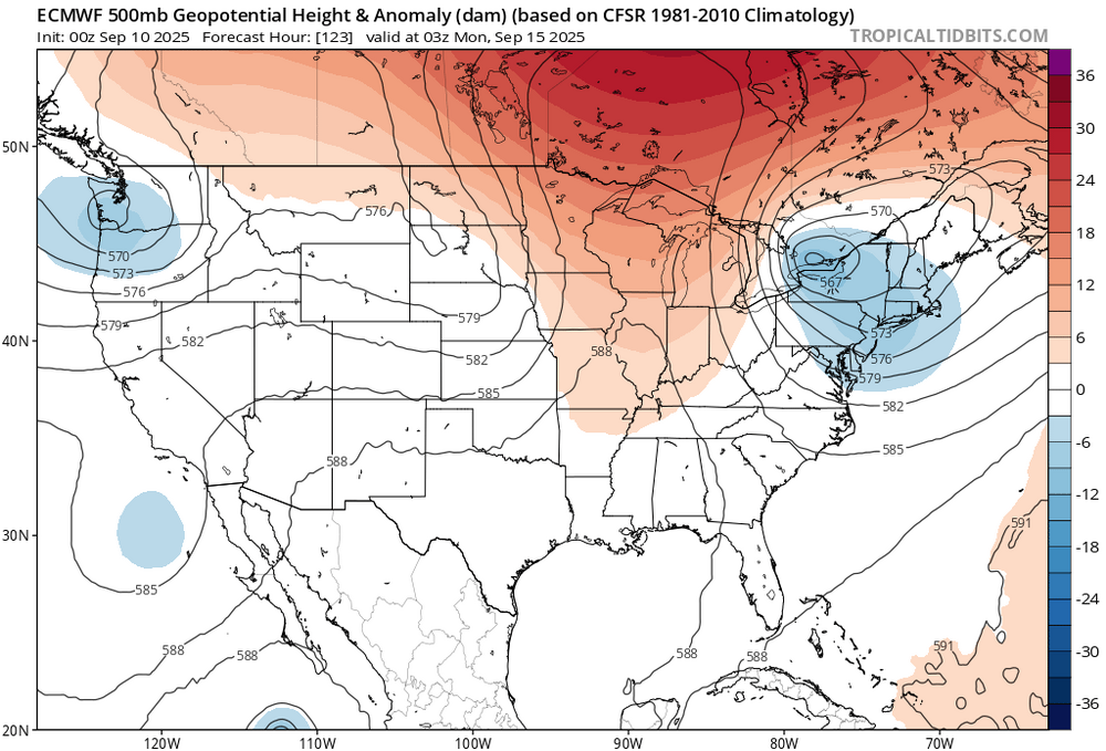
Yeah, hoping the Euro is correct about the heavy rain potential with the omega block and cutoff low next week.
-
Yeah I’ll take the early 40s for sunshine
-

September 2025 OBS-Discussion centered NYC subforum
wdrag replied to wdrag's topic in New York City Metro
So... I see very little mPing on the on going sprinkles to moderate showers occurring NJ/LI/NYC area... a little disappointing. I see .08 in 1 hr vicinity LGA in the last hr or two. Lets see how fast the clouds go away from the coasts... could be a day or two? How about the 16z Sunday-06z/Tuesday showery event... unusual pattern development but possible and ensembles agree, except the lightest GEFS which seems to be lagging. I'll side with the EPS/CMCE on this one and those who have plans late Sun or Mon ,may want to consider raincoats etc. -
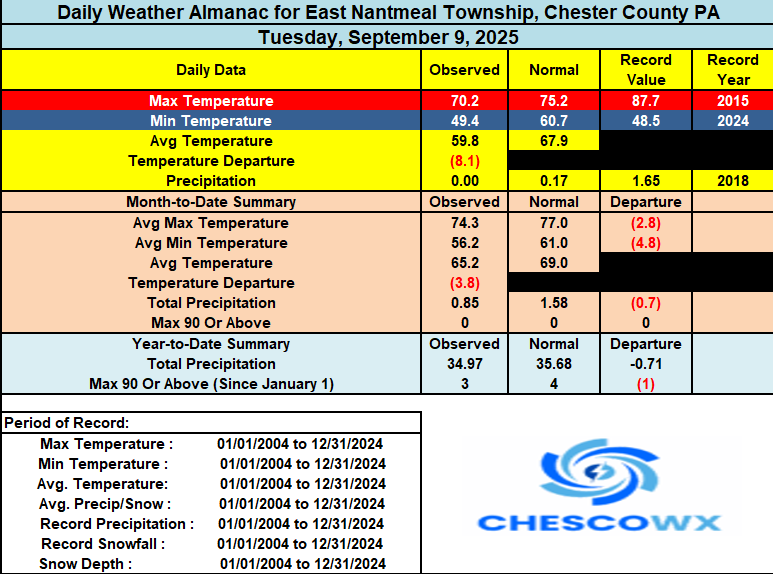
We have picked up some unexpected light rain that has resulted in at least 0.05" across some spots in the county this morning. These showers are backing off the ocean from a small storm off the NJ coast. There could be a couple more showers and clouds today with a continuation of our below normal temperatures. Sun returns tomorrow and we should have a great weekend with low humidity but slowly increasing temperatures. We may get near or slightly above normal by Friday before we turn a bit cooler again at the start of next week.
-
(002).thumb.png.6e3d9d46bca5fe41aab7a74871dd8af8.png)
E PA/NJ/DE Autumn 2025 Obs/Discussion
ChescoWx replied to PhiEaglesfan712's topic in Philadelphia Region
We have picked up some unexpected light rain that has resulted in at least 0.05" across some spots in the county this morning. These showers are backing off the ocean from a small storm off the NJ coast. There could be a couple more showers and clouds today with a continuation of our below normal temperatures. Sun returns tomorrow and we should have a great weekend with low humidity but slowly increasing temperatures. We may get near or slightly above normal by Friday before we turn a bit cooler again at the start of next week.
-

September 2025 OBS-Discussion centered NYC subforum
SACRUS replied to wdrag's topic in New York City Metro
Records: Highs: EWR: 98 (1983) NYC: 97 (1983) LGA: 95 (1983) JFK: 98 (1983) Lows: EWR: 44 (1938) NYC: 43 (1883) LGA: 50 (1978) JFK: 50 (1978) Historical: 1811: South Carolina was hit by a hurricane. The main highlight associated with the hurricane was a tornado that damaged downtown Charleston. 1900: South Dakota registered its maximum 24 hour precipitation record as 8.01 inches of rain fell at Elk Point, SD. (Ref. Wilson Wx. History) 1910: Duluth had the shortest growing season ever with frost free days from June 14 to September 10 (87days.) Normally the frost-free season is 143 days. (Ref. AccWeather Weather History) 1917: Duluth, MN saw its earliest freezing temperature reading with a record low of 31°. (Ref. Wilson Wx. History) 1919 - A hurricane struck the Florida Keys drowning more than 500 persons. (David Ludlum) 1944: Navy and Army Air Force B-24 Liberator planes flew into the "Great Atlantic Hurricane" from September 10th through the 15th. These were the first sanctioned military flights to obtain data on a hurricane. The data sent back was instrumental in helping hold the death toll from the destructive hurricane to 27 people. (Ref. Wilson Wx. History) 1947: Downpour across the Iron Range - Hibbing, MN got 8.6 inches in three hours. (Ref. AccWeather Weather History) 1960 - Hurricane Donna struck the Florida Keys, with winds gusting to 180 mph and a thirteen foot storm surge. The hurricane then moved north along the eastern coast of Florida and inundated Naples before moving out to sea. Hurricane Donna claimed fifty lives, injured 1800 others, and caused more than 300 million dollars damage. The Marathon/Tavernier area was almost completely destroyed, and in the Citrus Belt, most of the avacado crop was blown from the trees. Hurricane Donna wreaked havoc from Florida to Maine, with wind gusts to 100 mph along much of the coast. Hurricane Donna produced wind gusts to 121 mph at Charleston SC on the 11th, and wind gusts to 138 mph at Blue Hill Observatory MA on the 12th. The hurricane finally died over Maine two days later, producing more than five inches of rain over the state. (David Ludlum) (The Weather Channel) 1960: The center of Hurricane Donna passed over the middle of the Florida Keys between 2, and 3 am on this day. Donna was a Category 5 hurricane over the Atlantic and a Category 4 at landfall. This storm caused the deaths of over 100 in Puerto Rico, 50 in the United States, and 63 in a jet crash. The plane crash occurred on August 29th as a French airliner was attempting to land at Dakar, Senegal during a “blinding rainstorm.” The storm was likely a tropical disturbance at the time of the crash. 1961: On September 10th, the Television Infrared Observation Satellite observed an area of thunderstorms west-southwest of the Cape Verde Islands, suggesting a possible tropical cyclone. This storm is the first large tropical cyclone to be discovered on satellite imagery and would eventually become Hurricane Esther. 1965: After ravaging the Florida Keys on the 8th, Hurricane Betsy slammed in Louisiana with sustained winds of 125 to 130 mph and a minimum central pressure near 948 millibars or 28.00 inches of mercury. Houma, LA reported a wind gust of 130 mph. There were as many as 76 deaths and thousands injured. The storm surge and flooding from torrential rains caused an enormous amount of damage making this the greatest insured property loss in the U.S. up to this time. Betsy is known as first billion dollar hurricane with damage exceeding $1.4 billion dollars. (Ref. Wilson Wx. History) 1969: Birmingham, AL dipped to 49°; their earliest recorded temperature under 50°. Other record low temperatures included: Atlanta, GA: 49°, Tupelo, MS: 50°, Chattanooga, TN: 50°-Tied, Montgomery, AL: 52°, Meridian, MS: 52°-Tied, Macon, GA: 52°-Tied and Tallahassee, FL: 54°. (Ref. AccWeather Weather History) 1972: The Council Bluffs, Iowa area received wind damage and Shelby and Audobon Counties experienced a tornado. Rainfall totals in the three days from this date through the 12th were very impressive. Harlon, Iowa received 21 inches with 12.49 inches occurring on one day. Hundreds of families were left homeless from the flooding and losses of crops and buildings totaled nearly $20 million dollars. (Ref. Wilson Wx. History) 1976: Tropical Storm Kathleen moved northward from the Baja into the desert region of southern California; officially weakening to a depression just before crossing into the U.S. Yuma, AZ reported sustained winds of 57 mph, the highest on record associated with an eastern Pacific tropical cyclone in the southwestern U.S. A wall of water left a 700 foot wide, 40 feet deep gap at the Myer Creek Bridge on I-8 in Ocotillo, CA. The 4 to 6 foot high wall of water destroyed 70% of the homes. Daggett, CA received 2.28 inches of rain which was the greatest one day amount in recorded history. Overall, five people died and damage was estimated at $333 million dollars. (Ref. AccWeather Weather History) 1985: Late season heat wave ends in DC with seven straight 90° days. (Ref. Washington Weather Records - KDCA) 1987 - A late afternoon thunderstorm roared through Austin TX producing wind gusts to 81 mph, and 2.17 inches of rain in just sixty minutes. The high winds toppled six National Guard helicopters at the Robert Mueller Municipal Airport, and damaged or destroyed numerous other aircraft. (Storm Data) (The National Weather Summary) 1988 - Cool air sweeping into the north central U.S. brought snow to some of the higher elevations of Montana. The town of Kings Hill, southeast of Great Falls, was blanketed with six inches of snow. Tropical Storm Gilbert strenghtened to a hurricane over the eastern Carribean. (The National Weather Summary) (Storm Data) 1989 - Light snow fell in Montana overnight, with three inches reported at Fairfield. Billings MT reported a record low of 33 degrees. Unseasonably warm weather prevailed in the northeastern U.S., with record highs of 86 degrees at Caribou ME and 90 degrees at Burlington VT. (The National Weather Summary) (Storm Data) 1998: Tropical Storm Frances made landfall near Matagorda Bay, TX, causing the worst coastal flooding and beach erosion since Hurricane Carla in 1961. The storm's heavy rains ended a drought in East Texas but caused severe river flooding in parts of Texas and Louisiana. The highest rainfall total noted was 21.10 inches at Terrytown in southeast Louisiana. A major disaster declaration was issued for Cameron, Jefferson, Lafourche, and Terrebonne parishes in Louisiana. 1999: Straight line winds caused extensive damage at the Ardmore Industrial Park in Carter County, two miles northeast of Gene Autry, OK where a gust of 102 mph was measured. One aircraft hangar was completely destroyed and several were damaged. Several aircraft were overturned and three were destroyed. Damage was estimated at $2 million dollars. (Ref. Wilson Wx. History) 2008: Hurricane Ike emerged in the south-central Gulf of Mexico heading for the Texas coast with maximum sustained winds of 100 mph and a minimum central pressure of 27.91 inches of mercury. (Ref. Wilson Wx. History) 2009: Honolulu, Hawaii: Honolulu reports a record-tying high temperature of 92°F. (Ref. WxDoctor) 2017: Hurricane Irma crossed the Florida Keys as a Category 4 storm. 2018: Hurricane Florence was a powerful and long-lived Cape Verde hurricane, as well as the wettest tropical cyclone on record in the Carolinas and the ninth-wettest tropical cyclone to affect the contiguous United States. The sixth named storm, third hurricane, and the first major hurricane of the 2018 Atlantic hurricane season, Florence originated from a strong tropical wave that emerged off the west coast of Africa on August 30, 2018. Steady organization resulted in the formation of a tropical depression on the next day near Cape Verde. Progressing along a steady west-northwest trajectory, the system acquired tropical storm strength on September 1, and fluctuated in strength for several days over open ocean. An unexpected bout of rapid intensification ensued on September 4– 5, culminating with Florence becoming a Category 4 major hurricane on the Saffir–Simpson scale with estimated maximum sustained winds of 130 mph -
 It's better to have played and lost, than to have never played at all. Congrats WxUSAF!
 -

Pittsburgh PA Fall 2025 Thread
jwilson replied to TheClimateChanger's topic in Upstate New York/Pennsylvania
Generally worse for snow in the East. The overall regime from the last decade+ was a -PDO-led pacific, which has resulted in a sort of snow dearth, particularly along the East Coast. Granted, we don't rely on quite the same mechanisms here in the mountains, but decreasing snow chances can impact us just the same. Especially true if you're hunting for a big one. -
UK with the same gradient we have seen for the past several years, just north of my hood....I'll remove my spleen with a pair of plyers if this happens again.
-
September 2025 OBS-Discussion centered NYC subforum
SACRUS replied to wdrag's topic in New York City Metro
64 / 56 clouds and some areas of light showers drizzle. Clears out tomorrow - warms up upper 70s / low 80s through Sunday. Ridge over north with cutoff undercutting the ridge Mon - Tue clouds and some rain before flow comes around for an overall much warmer period with ridge into the northeast by the 9/16/17 and beyond. -
January blows
-
Decent snow for December on the EURO
-
^
-
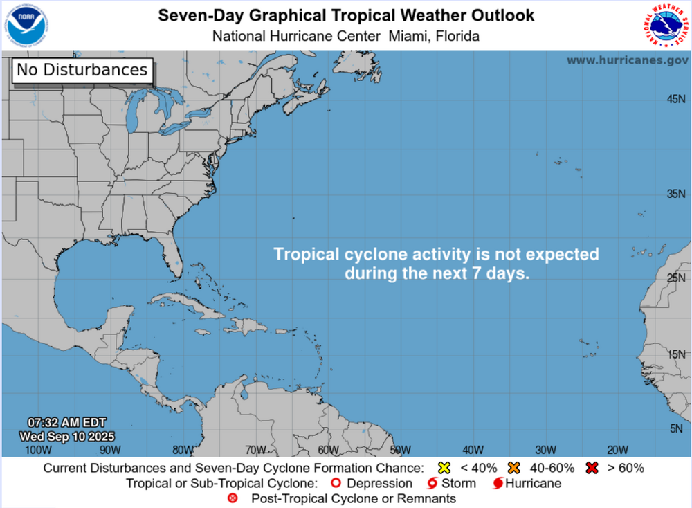
Happy Climatological Peak of Atlantic Hurricane Season Day!
-
some showers here but nothing heavy. 3k NAM on crack as usual, a good winter storm practice run when it showing a big hit
-
Same It has been a while
-
ready 2 b buried
-
Of course. Let's just hope we dont get above average Dec-Mar. 47 this morning for our coolest low since May
-
Real light rain in laurel as I inch along the BW parkway
- Today
-

2025-2026 ENSO
40/70 Benchmark replied to 40/70 Benchmark's topic in Weather Forecasting and Discussion
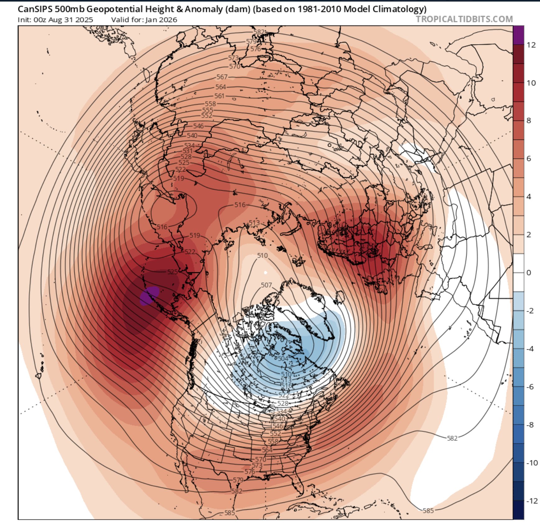
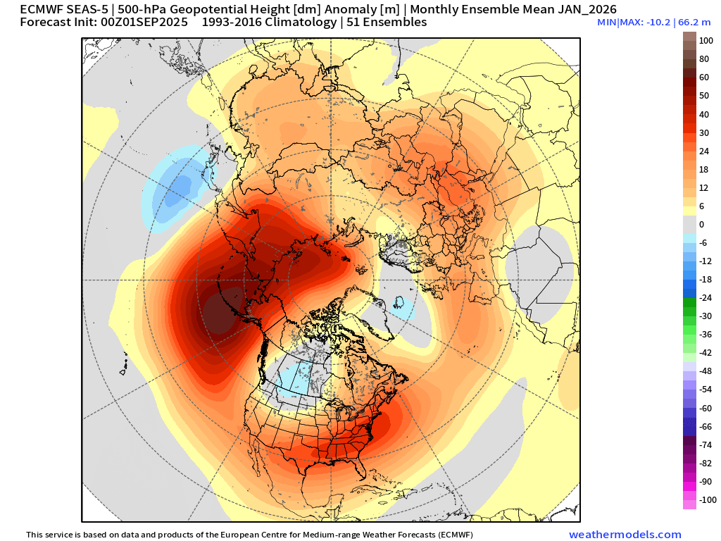
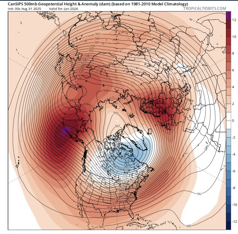
Yes, completely buy the poleward Aleutian ridging and trough being centered to our west...this is why I said while I don't think this will be a terrible winter for most of us, I also don't expect it to be a KU cookbook, either. There are going to messy systems, both in terms of precip type and/or verying degrees of phasing failures. I do think that the EURO has things biased a bit too far to the west, though. -
Had a high of 70 degrees yesterday and for the 3rd time in a row this week a low of 45 degrees again.
-
The seasonal models at this very early stage seem to like the idea of a very amplified Aleutians ridge. I am not looking at these long range forecasts for the exact locations of the ridge-trough axis yet. But several solutions both keep the trough axis to our west. Would match recent years where we get a Southeast Ridge or WAR influence for the Northeast. I want to see what the MJO activity and the rest of the October pattern looks like before refining the outlook more than these generalities.

-
2025-2026 ENSO
40/70 Benchmark replied to 40/70 Benchmark's topic in Weather Forecasting and Discussion
Yea, I expect the cold to again be centered over the northern plains and possibly GL. -
Clouds here and stuck in upper 50s thankfully.
-
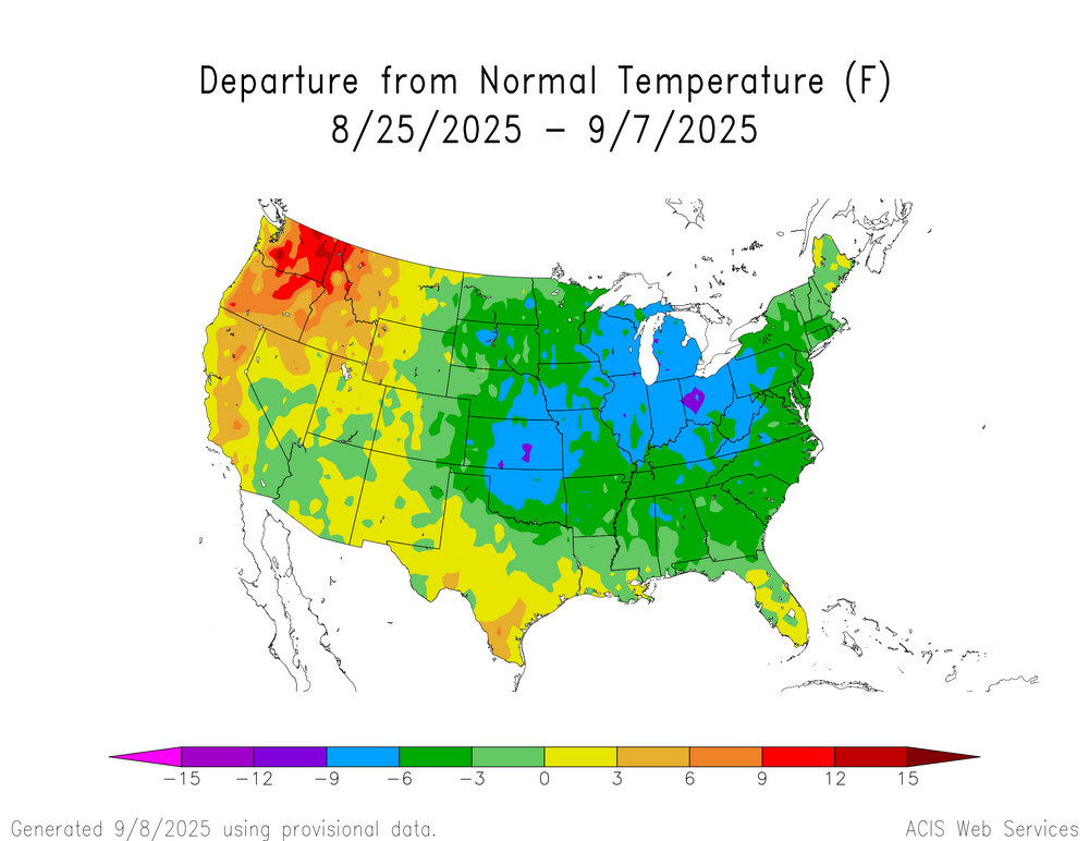
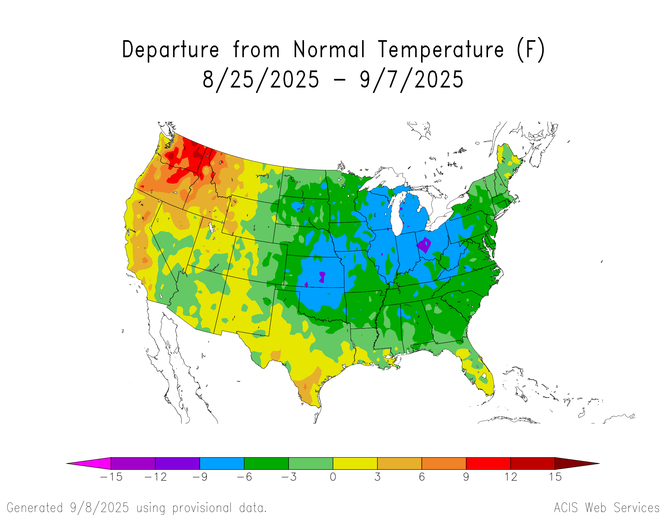
Yeah, the impressive cold outbreak over the last few weeks has been focused to our west again. The Columbus, OH area saw their 5th coldest 2 week Aug 25 to Sep 7 period. This has been a repeating theme since the 2015-2016 super El Niño global and national temperature jump. We saw this during this past winter when the coldest anomalies went to our SW and W. Then especially in February 2021 when the record cold went down the Plains and caused all the problems for Texas. Prior to this we had the record cold stay to our west in January 2019 when new all-time records for cold were set around Rockford, IL. The last impressive cold outbreak for a few weeks centered in the Northeast was back in late December 2017 into early January 2018. The last extended cold to be centered in the Northeast was JFM 2015. Time Series Summary for Columbus Area, OH (ThreadEx) top 5 coldest Aug 25 to Sep 7 Click column heading to sort ascending, click again to sort descending. 1 1885-09-07 61.9 0 2 1915-09-07 64.3 0 3 1891-09-07 64.6 0 4 1896-09-07 64.7 0 5 2025-09-07 64.8 0 - 1988-09-07 64.8 0 - 1967-09-07 64.8 0