All Activity
- Past hour
-

First Winter Storm to kickoff 2025-26 Winter season
Baroclinic Zone replied to Baroclinic Zone's topic in New England
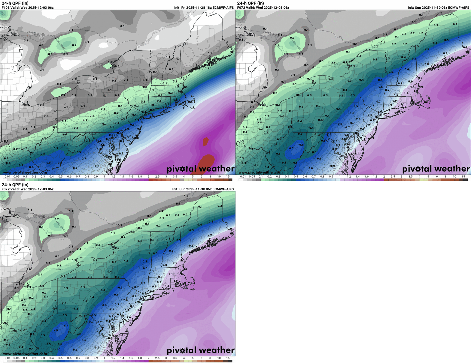
It’s really coming down to intensity and how mid-levels act. Euro is just a bit more organized, mitigating any warm air intrusion beyond the south coast, while the GFS brings that further inland about 30 miles. -
Snow/sleet in Potomac
-

First Winter Storm to kickoff 2025-26 Winter season
dendrite replied to Baroclinic Zone's topic in New England
-
Nov 28-30th Post Turkey Day Winter Storm
Chicago WX replied to Chicago Storm's topic in Lakes/Ohio Valley
8.5" final here. If we didn't have an afternoon lull, dd's might have been in play. Regardless, 13.9" of snow in November IMBY. Pretty remarkable. And looks like a nice little refresher coming tomorrow afternoon/evening. What a start to the season. -
-
Snow in Columbia!!!
-
First Winter Storm to kickoff 2025-26 Winter season
Snowcrazed71 replied to Baroclinic Zone's topic in New England
I truly wouldn't put much stock into their forecast. It's going to change. -
First Winter Storm to kickoff 2025-26 Winter season
Kitz Craver replied to Baroclinic Zone's topic in New England
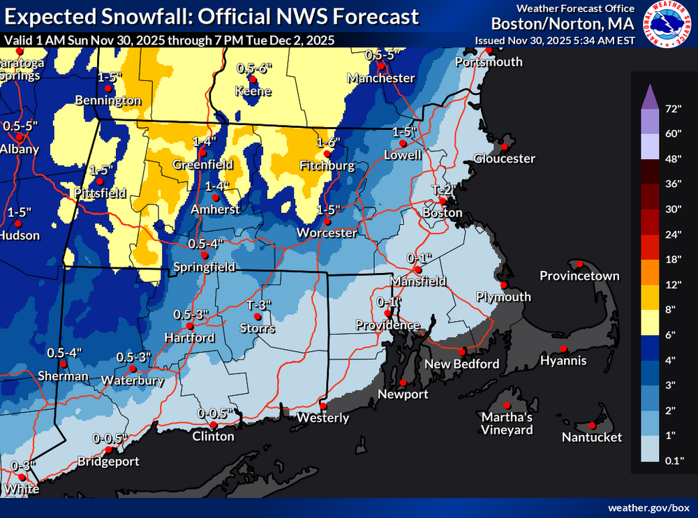
Anecdotally my phone forecast went from 1-3” with .5 rain before I went to bed back up to 7-9” this morning. Doesn’t mean much, but happy it didn’t go the other way for what it’s worth -
First Winter Storm to kickoff 2025-26 Winter season
mahk_webstah replied to Baroclinic Zone's topic in New England
GYX is aggressive here with 5-9 in zones plus more in the early evening. Going with blend on qpf of .7-1.0 -

First Winter Storm to kickoff 2025-26 Winter season
Damage In Tolland replied to Baroclinic Zone's topic in New England
Looks like a very bad forecast -
First Winter Storm to kickoff 2025-26 Winter season
Kitz Craver replied to Baroclinic Zone's topic in New England
Looks like a GFS/NAM leaning forecast -
Nov 28-30th Post Turkey Day Winter Storm
jlauderdal replied to Chicago Storm's topic in Lakes/Ohio Valley
Still snowing and winds have increased significantly. Saw two accidents happen yesterday, typical snow fender bender and another in the ditch. Widespread win for this board, the Monday system looks more likely to over achieve than under, liking the trends on the latest cycle. -
First Winter Storm to kickoff 2025-26 Winter season
Snowcrazed71 replied to Baroclinic Zone's topic in New England
Aren't they always the most cautious. They are the same with their temp outlooks too. -

Central PA Fall Discussions and Obs
Voyager replied to ChescoWx's topic in Upstate New York/Pennsylvania
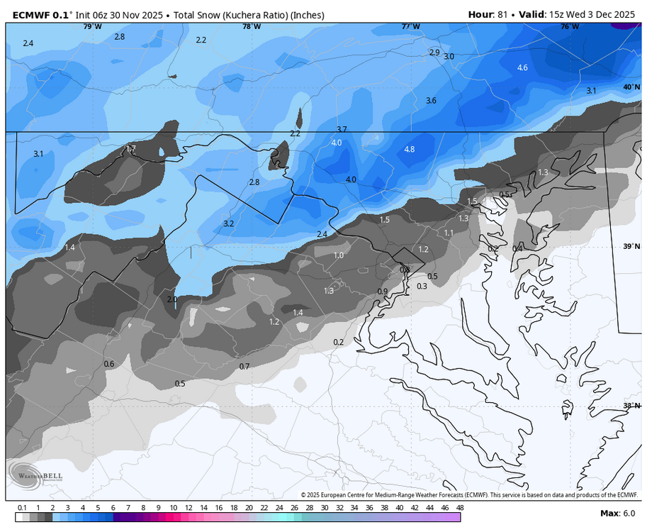
Sounds like watches may be hoisted for some later on this afternoon. The latest WPC probabilities of 0.25" or greater liquid equivalent snow/sleet paint medium probabilities (40-70%) across most of the region, with slightly lower amounts expected in northwest PA. The latest Winter Storm Outlook highlights a 30-50% chance of Warning criteria snowfall (5"+) in northeast PA, primarily east of US-15. GEFS and ECENS probabilities of 6"+ have trended up a bit also supporting the 30-50% probability in the Poconos, with an even higher likelihood up through coastal New England. If the current track/timing holds, watches may be needed in the next forecast cycle. At this time, though, a plowable snowfall seems like a reasonable bet for most of the region. Guidance has remained consistent overall for snowfall amounts with the last two runs, however some uncertainty remains whether or not warm nosing above the surface could limit snow across the PA/MD border. If mixing is a problem for anywhere in Central PA, it would be for locations southeast of US-30 in York and Lancaster County. Continue to monitor the forecast in the days ahead, especially if you have plans to travel. -
GEFS still the outlier with trough out west leading to much warmer conditions east & ridging. Bet snowman loves that
-

First Winter Storm to kickoff 2025-26 Winter season
Damage In Tolland replied to Baroclinic Zone's topic in New England
T-3” here? Lol -
First Winter Storm to kickoff 2025-26 Winter season
Kitz Craver replied to Baroclinic Zone's topic in New England
GFS cooled off pretty good and lost the double barrel thing. Looks decent -
We'd probably get a solid storm if airmass was a little colder. Pretty nice track actually
-

Central PA Fall Discussions and Obs
mahantango#1 replied to ChescoWx's topic in Upstate New York/Pennsylvania
medium.com LOOKING AT DEC 2025 — Why this Skeptic is excited and impressed if you like cold and snow across… https://l.facebook.com/l.php?u=https%3A%2F%2Ftinyurl.com%2F4zz29cpf%3Ffbclid%3DIwZXh0bgNhZW0CMTAAYnJpZBExRHFKR3d5eWZkWFh4N3NIdXNydGMGYXBwX2lkEDIyMjAzOTE3ODgyMDA4OTIAAR64Db6hrzhHBqw9PcwAS_B5-GW7RMqvcBp4PPSaf-AqtHxDk-982emevvrHCA_aem_djIOIOJplYY6yNXOtcGdTQ%26brid%3D9LBgYp824EHizRWAjxURkQ&h=AT0MjW5gCTgagc5MCYFz7VyTgHLbtmZ_50_x1jSbjkzF32pa08tj9uY6yfnase-cUcozv7fbsLlJA9t1kSTZE7vtVx_F0NL7ExaSTxhPNQZqFyLIjTa4nqc3xLFgrC6zIwZHz5NXMM3Hmg&__tn__=-UK-R&c[0]=AT2bvekVPFHdsvbm9EJjV7o_uzJq5lokP7RefAaHUds3cVz5tyeljQcBcJiNXyqBfySk6YHBR6kkNbLGX2hmjhglyTWo1_Hk2bFacZEd-0GnZLWQeWJGCtGDsP3EjoGtbgx31K54epNRBnaBNtwdXcej2QxAtWv5Y2FSAWR0wjKrzTwwhBC8BLsgaItGmTVSgkgs2L_JpYRxX_8LB7nqKeBVItuTjQ -

First Winter Storm to kickoff 2025-26 Winter season
ineedsnow replied to Baroclinic Zone's topic in New England
-

First Winter Storm to kickoff 2025-26 Winter season
ineedsnow replied to Baroclinic Zone's topic in New England
Rates could be wild for a bit if things break right.. 6z GEFS mean bumped up to 7 for here -
Initial point and click of 6-8”, looks reasonable at upper bound. If we can just figure out NAM being out to lunch a decent starter storm will be at hand.
-
Heads up for early risers in the metros - looks like maybe a chance of some frozen / mixed precip until 8 am or so…
- Today
-
That’s a rather nice run.

