All Activity
- Past hour
-
That's because they're preparing for winter. They're making sure they know how to properly screw us.
-

Spooky Season (October Disco Thread)
CoastalWx replied to Prismshine Productions's topic in New England
It will fuck up Halloween. -
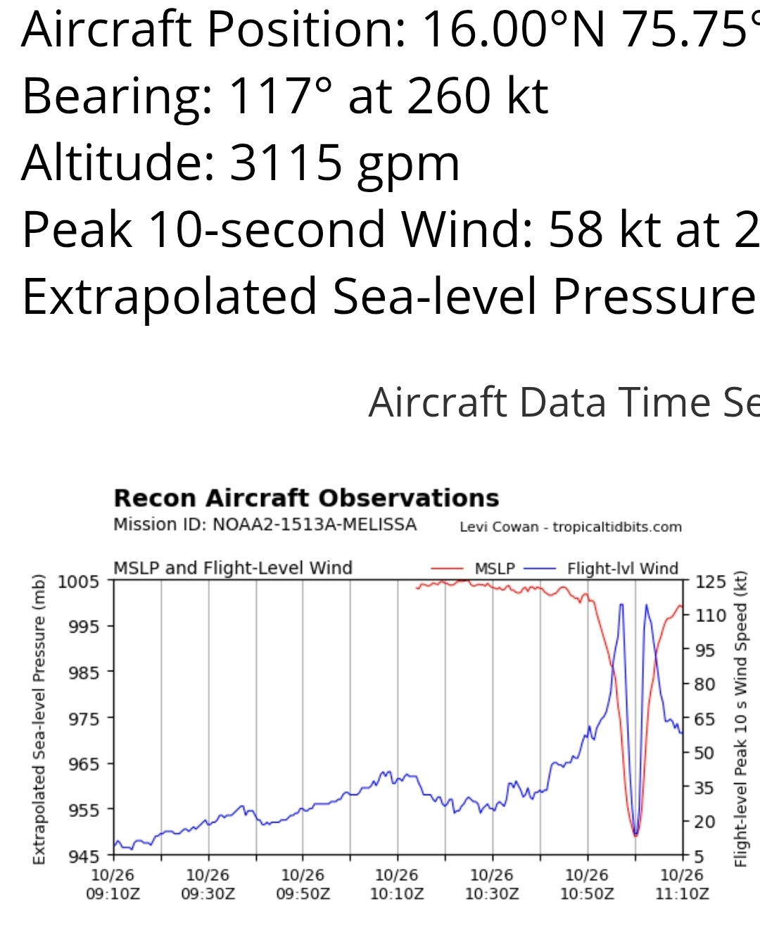
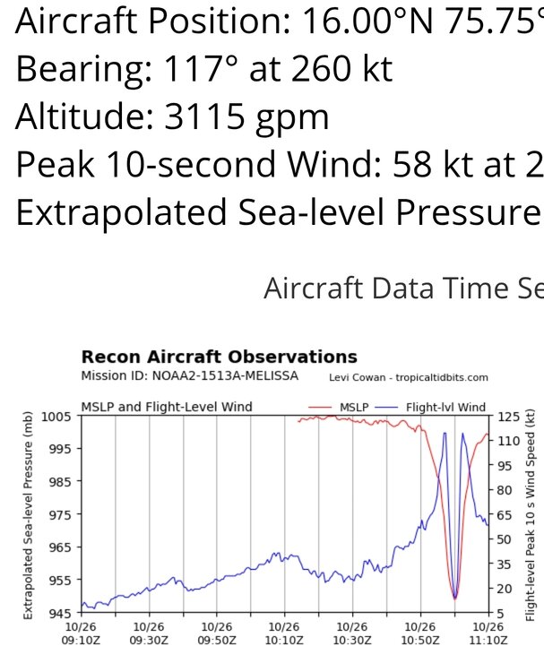
First pass of the morning shows it weaker than NHC estimated. Is it topping out?
-

Spooky Season (October Disco Thread)
kdxken replied to Prismshine Productions's topic in New England
Yeah, hopefully we get lucky and nothing out of it. -

E PA/NJ/DE Autumn 2025 Obs/Discussion
Birds~69 replied to PhiEaglesfan712's topic in Philadelphia Region
7am, 35F..sun just about to rise. -
That is beautiful and terrifying all at the same time. That southeast part of the island is probably already wrecked too.
-
140mph on 5am eye really contracting now
-
We've seen these trochoidal wobble around islands including Jamaica, as well. Especially the slow w/wsw drifters. There are a variety of scenarios that are less than "worst-case", a little early to be declaring anything
-
Gfs was an embarrassment with this.
-
No thread yet--- not at tipping point for a 60% or greater moderate impact worthy forum event. WPC increased their qpf overnight. GFS and CMC modeling more ominous and even the 5H westward EC suite putting us on the edge but for now, all obs-disc can remain here. Will rereview late today-don't want to overstate. This will have travel impact here...certainly late Thu-early Fri and those who have to be somewhere on time might consider possible adjustments if below comes to fruition. To me... looks like minimum 1/2- maximum 3" rain event with max coastal gust 45-55 MPH late Thu-early Fri when it should be at its worst here w associated leafed tree breakage inducing power outages. Minor coastal flooding possible Thu afternoon or Fri morning high tide cycle but first quarter lunar cycle is not favorable for easier flooding.. Max 2-3" rainfall axis could still split the forum to the west and east but for now the target is as WPC has it... I95 eastward and so if all goes well-beneficially- we'll see October rainfall end up within 1/2" of normal... somewhere between 3.3-4.3"--thats a guess that sides with the WPC 09z rainfall forecast. Noting CP October rainfall is 0.4" above all other OKX Climate sites. Will check in late today--have a good day.
-
.. and to everybody that said the GFS was onto something, you should remember that too. Dangerously incorrect comments from some of you.
-
Spooky Season (October Disco Thread)
CoastalWx replied to Prismshine Productions's topic in New England
Looks like a meh’easter friday. Probably ruins Halloween. - Today
-
Unless we start seeing upward wave fluxes into the stratosphere and warmings, the SPV is going to have no choice but to cool and strengthen in November. There is zero indication right now of any “top down” warmings coming. It’s also looking more and more likely that the MJO doesn’t make it past the ‘Maritime Barrier’ on this current cycle
-
But then some people wouldn't have anything to post! Haha.
-
Yes, I am a weenie!!!
-
Now 29/28 at 6am. Feels kinda chilly out there. That's KEEN, Almost 200 feet higher. We are often a few degrees colder here in Brattleboro, which is about 300 ft. ASL at the Connecticut River, when we have thermal inversion. BTW, finally getting a new outdoor thermometer at my new apartment next month...
-
Eye continuing to clear on IR, suggesting intensification is continuing.
-
What’s great is they’re only 10min apart from each other.
-

Spooky Season (October Disco Thread)
Baroclinic Zone replied to Prismshine Productions's topic in New England
She’s a CAT 4 this AM. -
Phrasing…
-
Has anyone heard from @RUNNAWAYICEBERG? He seems to be MIA
-
She's gonna be a beaut. I really can't believe we're watching the worst case scenario for Jamaica play out before our eyes. Especially a country that has avoided very many destructive hurricanes in the past but that luck as finally run out sadly. Like even if Melissa was moving normally this would still be one for the history books but given the slow speed, angle of approach and absolute monster strength it's going to be something that they may never see again for hundreds of years. I really do not think many know what's truly coming.
-

Spooky Season (October Disco Thread)
ineedsnow replied to Prismshine Productions's topic in New England
She has a eye now and bombing out -
Incredibly sobering look for those in Jamaica.
-
Melissa's eye is clearing out fast now.