All Activity
- Past hour
-
 I woke up around 3:00 to thunder and was psyched. Looked at radar and went back to bed. Thank you Mr. Steiner. When you hit, you hit hard
 -
Max here yesterday was 90.1 at 1:09 pm. 68⁰ now with a noisy thunderstorm in progress. 0.40" in the guage so far. Nice!
-
Quick heavy burst-hoping we get more Lots of lightning to north
-

Central PA Summer 2026 Discussion/Obs Thread
mahantango#1 replied to Voyager's topic in Upstate New York/Pennsylvania
My June total rain fall was 2.95 Eric Finkenbinder Ssodtpeorn9201th15agtm456l1iu194u6u50tfu73811fi9m3th867i28t9 · While extreme heat takes headlines this week, I'm increasingly concerned about our growing rain deficit. Storm chances return this weekend, but storm coverage appears limited. -
Solid storm out here
-
Central PA Summer 2026 Discussion/Obs Thread
mahantango#1 replied to Voyager's topic in Upstate New York/Pennsylvania
Extreme Heat Warning URGENT - WEATHER MESSAGE National Weather Service State College PA 211 AM EDT Wed Jul 1 2026 PAZ019-026>028-036-045-046-049>053-056>059-063>066-012100- /O.CON.KCTP.XH.W.0001.260701T1600Z-260704T0000Z/ /O.CON.KCTP.HT.Y.0003.260704T0000Z-260705T0000Z/ Southern Centre-Huntingdon-Mifflin-Juniata-Franklin-Southern Clinton-Southern Lycoming-Union-Snyder-Montour-Northumberland- Columbia-Perry-Dauphin-Schuylkill-Lebanon-Cumberland-Adams-York- Lancaster- Including the cities of Newport, Mount Union, Selinsgrove, Pottsville, Lewisburg, Carlisle, Lewistown, Mifflintown, Chambersburg, Gettysburg, York, Shamokin, Berwick, Lebanon, Lancaster, Harrisburg, State College, Hershey, Lock Haven, Sunbury, Huntingdon, Williamsport, Danville, and Bloomsburg 211 AM EDT Wed Jul 1 2026 ...EXTREME HEAT WARNING REMAINS IN EFFECT FROM NOON TODAY TO 8 PM EDT FRIDAY... ...HEAT ADVISORY REMAINS IN EFFECT FROM 8 PM FRIDAY TO 8 PM EDT SATURDAY... * WHAT...For the Extreme Heat Warning, dangerously hot conditions with heat index values up to 110 expected. For the Heat Advisory, heat index values up to 104 expected. * WHERE...A portion of central Pennsylvania. * WHEN...For the Extreme Heat Warning, from noon today to 8 PM EDT Friday. For the Heat Advisory, from 8 PM Friday to 8 PM EDT Saturday. * IMPACTS...Heat related illnesses increase significantly during extreme heat and high humidity events. * ADDITIONAL DETAILS...High temperatures will exceed 100 degrees in many places today, Thursday and Friday with even higher heat index values expected. Temperatures will be a few degrees lower on Saturday, but heat risks will continue. PRECAUTIONARY/PREPAREDNESS ACTIONS... Know the signs and symptoms of heat exhaustion and heat stroke. Review heat safety and preparedness information at weather.gov/safety/heat. To reduce risk during outdoor work, the Occupational Safety and Health Administration recommends scheduling frequent rest breaks in shaded or air conditioned environments. Power outages are possible during periods of extended heat as the extra demand for electricity can tax the power grid. Be prepared for a possible power outage. -
 Solid inch so far
 -
 East of the river stein baby
 -
 WxWiz AM PT?
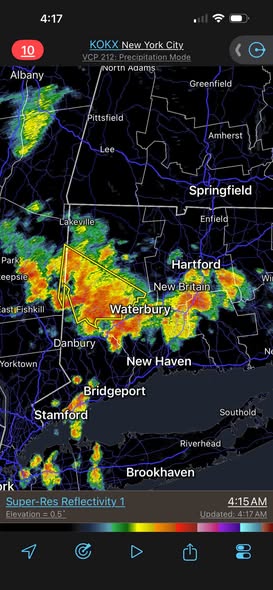

-
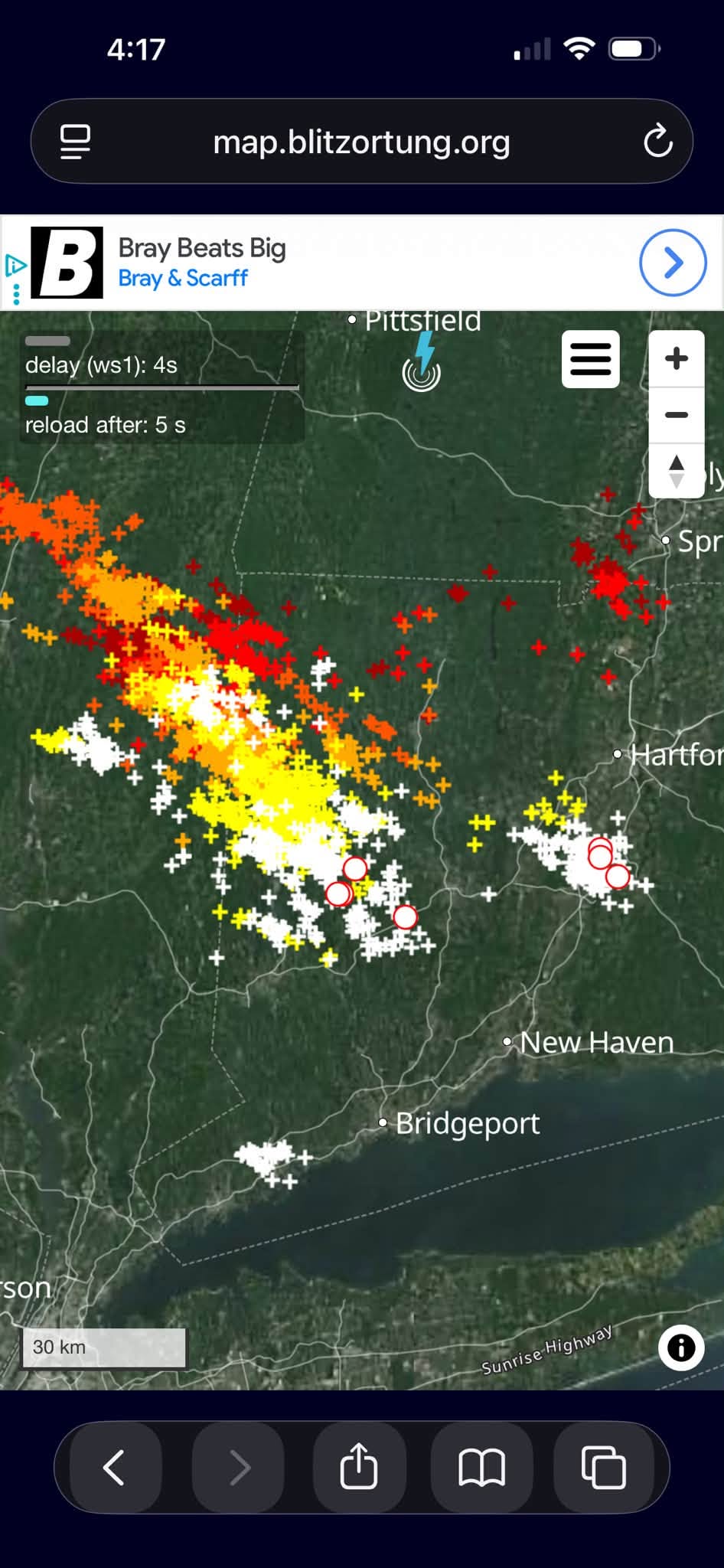
Western conn is just getting hammered right now from that complex heading south. Why do they keep stealing all of the fun out towards the western frontier? It’s not fair, damnit!
- Today
-

Occasional Thoughts on Climate Change
Silver Meteor replied to donsutherland1's topic in Climate Change
Ten Hottest Days in Washington, D.C. History https://knoji.com/article/10-hottest-days-in-washington-dc-history/ -
 It be thundering, yo...
 -
Clouds a sig problem today w/ AM convection and dirty ridge clouds, so temps held back despite 1000-500 thk getting to 580 by 00z. GFS has 98-102 across SNE Thu-Fri. That appears reasonable. The MCS is of concern. CAPE up to 4600 in VT late in the day, and still near 3000 in SNE 2-3am Thu just ahead of it, which is outstanding for this area at this time of day (WxWiz EML!). HRRR shows the MCS quite strong. RRFS/NAM/ECMWF oddly do not have it, but the GFS does.
-
 Best light show in years and I had to go to Saranac Lake for it.
 -
 Great production. It took me like 28 days of bluebird August 2025 to hit 2MWh in a month. How much does the pool filter add to your consumption?
 -

2026-2027 Super El Nino
Stormchaserchuck1 replied to Stormchaserchuck1's topic in Weather Forecasting and Discussion
You have to wonder if something is keeping the arctic artificially cool in the Summer since record low levels in 2012. It makes sense - it will take 1 million years to create 1 million year old ice again. Probably not at least directly, but it is a thought that crossed my mind fwiw. -
My total rainfall in June was ~5.35”.
-
I am not a blind defender, man. In another social media outlet, people got on me for being too negative when I said the season was likely over after the Blue Jays series last month and them losing 4 in row after appearing to gain momentum. I think some mistook my vigorous back-and-forth with @Chris78 a couple years ago as me being a kool-aide drinker...whereas that debate was over the culpability of ownership that was just getting settled in. And for the record now this IS their responsibility...they may have made a mistake not firing Elias & Sig and starting completely fresh in the FO. But DEFINITELY this year...they HAVE to fire him, or else they would be choosing even more mediocrity. On Albernaz: I think we should reserve judgement for now. The problems we see were here before he got here...and I'm starting to wonder even if a Bocci-type grizzled veteran would've been able to fix the issues in a year. And again, with the Elias problem...even less so. So I'm not sure about Alby yet, tbh On selling: Other than Ward, Rogers, maybe Cowser, Kittridge...I don't think selling is the answer. The core we have I am almost certain will play well elsewhere--especially Gunnar. It's something deeper going on in the org that is messing them up right now. If they show Elias the door, the more system-wide problems could improve, and this same group finally plays to their potential. And besides...they know fans do NOT want to see another full-scale rebuild with more 100-loss seasons to come. Sell the young core and that's almost a guarantee. And from a talent standpoint--that drastic of a step is may not be necessary right now. And besides...we literally had a firesale last year. In summary: I'd much rather they clean out the front office first and keep the young core intact...that would address the issues that got us here better.
-
We’re weenies-extremes are where it’s at-bring it!
-

Central PA Summer 2026 Discussion/Obs Thread
Jns2183 replied to Voyager's topic in Upstate New York/Pennsylvania
All I got to today was 91, dp 68, hi 95 Sent from my SM-S731U using Tapatalk -
I've wanted to use torrid, but it implies dry or parched, so that matches desert-type heat better.
-
Idiot AI. 1.3 mi from the summit as if that is a fair comparison when dealing w/ sharp elevation. I've played w/ AI query for historical wx, and it messes up a lot. Conflates events and overlooks obvious details that make all the difference.
-
June finished at 71.4 here. Last June was 71.1. Pretty close
-

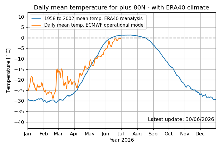
2026-2027 Super El Nino
GaWx replied to Stormchaserchuck1's topic in Weather Forecasting and Discussion
It’s official. The DMI daily mean Arctic temp N of 80N, with the help of a +AO, never made it up to freezing in June! The previous latest to first get to freezing was June 20th, set in 2013. The June 30th # was -0.25C. Let’s see whether it gets above 0C on July 1st: @Stormchaserchuck1