All Activity
- Past hour
-
Will be a good run for southside and NC. Maps soon.
-
-
February 2026 Medium/ Long Range Discussion: Buckle Up!
Snowman. replied to Weather Will's topic in Mid Atlantic
CMC crushes NC again like they need more snow. -
Jan 30th-February 1st 2026 Arctic Blast/ULL Snow OBS Thread.
Scottie16 replied to John1122's topic in Tennessee Valley
ULL finally moved and allowed the cold air to come off the plateau. You can see it on the lower level water vapor. I just dropped from 28.8 to 26.2 in under 10’mins . -
HRDPS has about .6 of precip for southside
-

January 30th- Feb 1st ULL and coastal storm obs
Leesville Wx Hawk replied to JoshM's topic in Southeastern States
Really cool, I was sorta surprised. . -
Yep wasted cold without any storms to track is the worst. And this generally looks like a suppressed to hell pattern. Maybe we get lucky with a clipper or two to refresh the snowpack.
-
Go time. Gonna be interesting. Waning - NAO - does that effect south push? Overall H5 generally favorable for the next 10 days with a bonafide small break. .
-

The “I bring the mojo” Jan 30-Feb 1 potential winter storm
Regan replied to lilj4425's topic in Southeastern States
Too bad this Hrrr only goes out to about 4pm. Wonder what we’d have ended up with -

The “I bring the mojo” Jan 30-Feb 1 potential winter storm
NYweatherguy replied to lilj4425's topic in Southeastern States
Radar is filling in nicely in N. Georgia. It's already snowing at my buddy's house in Dahlonega. -

The “I bring the mojo” Jan 30-Feb 1 potential winter storm
Snowncanes replied to lilj4425's topic in Southeastern States
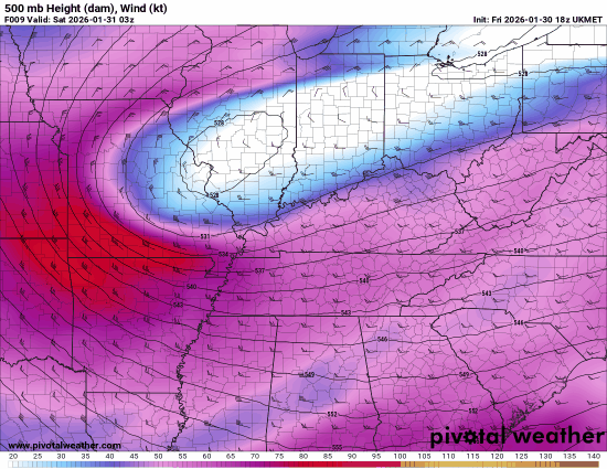
Models that are most correct with this feature at this point in time: RDPS, RAP, UKMET, in that order. Doesn’t necessarily mean to treat these as gospel but have a better chance of accurately depicting downstream if you’re not way off of a major feature (looking at you HRRR)
-
-

Jan 30th-February 1st 2026 Arctic Blast/ULL Snow OBS Thread.
Reb replied to John1122's topic in Tennessee Valley
What’s everyone doing to stay up all night? We could’ve all rented out a Gatlinburg air bnb for this one but our luck it would have busted lol -
 Radar starting to ignite
 -
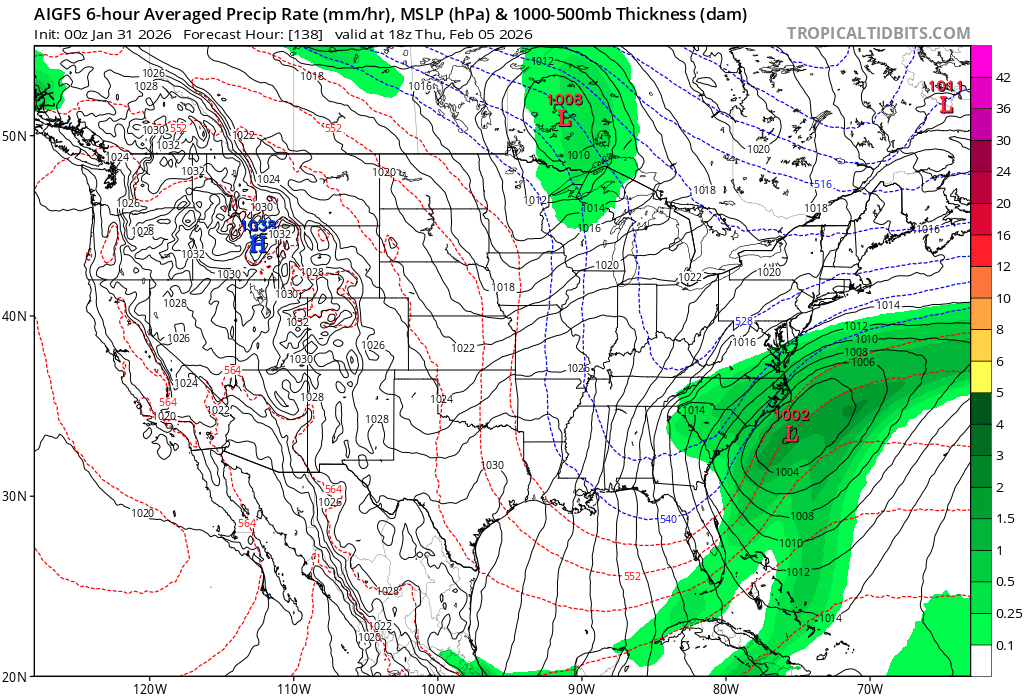
AIGFS has more precp with a weaker low further offshore. This should be what the GFS shows for tomorrow. And yes, if this happens its a big storm for SEVAand RIC
-
January 30th- Feb 1st ULL and coastal storm obs
WinstonSalemArlington replied to JoshM's topic in Southeastern States
Things are starting to pop -

The “I bring the mojo” Jan 30-Feb 1 potential winter storm
kvegas-wx replied to lilj4425's topic in Southeastern States
Ham and egg all the way my man!! Did you know you can order double meat? Or even double egg or cheese! Just ask when you order. The AI struggles with it though. -

The “I bring the mojo” Jan 30-Feb 1 potential winter storm
PackGrad05 replied to lilj4425's topic in Southeastern States
03Z HRRR fills in much faster for Wake. Hopefully the start of a good trend -

Richmond Metro/Hampton Roads Area Discussion
wasnow215 replied to RIC Airport's topic in Mid Atlantic
Makes zero sense surface would be warm lol -

Jan 30th-February 1st 2026 Arctic Blast/ULL Snow OBS Thread.
bearman replied to John1122's topic in Tennessee Valley
Yep it is time to try and go to sleep we have stopped here with the snow. Hopefully we will wake up to some big rates. -
The “I bring the mojo” Jan 30-Feb 1 potential winter storm
CoolBreeze replied to lilj4425's topic in Southeastern States
When I look at the wind field on Ventusky, the center of circulation appears to be about 50 miles off the SC coast, and it's been moving slowly parallel to the coast all evening. I hope that means the low will hug the coast more than the models have said as it deepens... -

Jan 30th-February 1st 2026 Arctic Blast/ULL Snow OBS Thread.
BlunderStorm replied to John1122's topic in Tennessee Valley
Getting frigid out there! 16.5F. Rates have picked up yet flakes are falling individually like grains of sand. 3 1/2 inches on the measurement surface and a snowpack of 4 1/2 inches in the grass. Sledding should be fun tomorrow! I'm calling this event a win -
AIGFS midweek

-
Waiting for the "radar is verifying north of the models" posts. Always a crowd pleaser.
-
January 30th- Feb 1st ULL and coastal storm obs
kvegas-wx replied to JoshM's topic in Southeastern States
Its hammering in Stuart now. Snowing sideways and now windy on the cams. Going to be rapid accums if that keeps up. Thanks to some knowledgable posters this morning, my Starlink heater is on and my wifi cams are working perfectly. Love this place!