All Activity
- Past hour
-

September 2025 OBS-Discussion centered NYC subforum
SACRUS replied to wdrag's topic in New York City Metro
Records: Highs: EWR: 94 (1970) NYC: 97 (1895) LGA: 93 (1970) JFK: 90 (1970) Lows: EWR: 40 (1947) NYC: 41 (1947) LGA: 42 (1947) JFK: 43 (1963) Historical: 1722: La Nouvelle-Orléans (New Orleans) was founded May 7, 1718, by the French Mississippi Company, under the direction of Jean-Baptiste Le Moyne de Bienville, on land inhabited by the Chitimacha. Four years later, a hurricane destroys nearly every building in the village, including the only church and hospital. 1785: The "most tremendous gale of wind known in this country" passed over the Lower Chesapeake Bay and went along a track very similar to the Chesapeake-Potomac Hurricane of 1933. At Norfolk, lower stories of dwellings were flooded. Warehouses were totally carried away by the storm surge, causing large amounts of salt, sugar, corn, and lumber to disappear. A large number of cattle drowned, and people hung onto trees for dear life during the tempest. At Portsmouth, the entire town was submerged. Forrest's book, Sketches of Norfolk, offers this account of the storm: " This year, 1785, was noted for the highest tide ever before known to Norfolk, completely deluging a large portion of its site on the water side". Almost all ships in the area were driven from their moorings near Norfolk. No less than 30 vessels were seen beached after the storm. Damages totaled £30,000. At least two died due to shipping disasters. After ravaging Virginia, the system tracked up the coast to Boston. (Ref. Hurricane of 1785) 1815 - One of the greatest hurricanes to strike New England made landfall at Long Island and crossed Massachusetts and New Hampshire. It was the worst tempest in nearly two hundred years, equal to the hurricane which struck in 1938, and one of a series of severe summer and autumn storms to affect shipping lanes that year. (David Ludlum) 1903: Bakersfield, CA dropped to 31°, their earliest below freezing temperature. (Ref. Wilson Wx. History) 1904 - The temperature at Charlotteburg, NJ, dipped to 23 degrees, the coldest reading of record for so early in the autumn for the state. (The Weather Channel) 1937: From summer to winter. The temperature was 101 at Wheaton. Then a cold front came through causing the mercury to tumble below freezing. (Ref. AccWeather Weather History) 1975: On September 22, Hurricane Eloise intensified to attain Category 2 strength, and became a major hurricane of Category 3 status shortly after that as it turned towards the northeast. Several ships penetrated the storm's center during its passage through the Gulf. Hurricane Eloise continued to strengthen until it reached its peak winds of 125 mph and a minimum barometric pressure of about 955 mbar. It moved ashore along the Florida Panhandle near Panama City on September 23. 1983 - A thunderstorm downburst caused a timber blowdown in the Kaibab National Forest north of the Grand Canyon. Two hundred acres were completely destroyed, and scattered destruction occurred across another 3300 acres. Many trees were snapped off 15 to 30 feet above ground level. (The Weather Channel) 1984: An early season snowstorm brought more than a foot of snow to some locations in the northern Plains and Rockies. Amounts of 6 to 12 inches were common over Harding and Perkins Counties as well as portions of Meade and Butte Counties in South Dakota. Camp Crook in Harding County reported 14 inches. Roads in these areas were covered with snow and slush and became icy. It was the snowiest September day on record at Sheridan, WY and Billings, MT with 12.9 inches and 6.2 inches respectively. Other snowfall totals included: Broadus, MT: 12 inches, Columbus, MT: 10 inches, Nye, MT: 10 inches, Clearmont, MT: 10 inches, Hysham, MT: 8 inches, Red Lodge, MT: 7 inches. (Ref. Wilson Wx. History) 1985: Early snow over portions of Minnesota and western Wisconsin. Just under a half inch (.4) recorded at the Twin City Airport. Most of it fell during the afternoon. (Ref. AccWeather Weather History) 1987 - Autumn began on a rather pleasant note for much of the nation. Showers and thunderstorms were confined to Florida and the southwestern deserts. Warm weather continued in the western U.S., and began to spread into the Great Plains Region, but even in the southwestern deserts readings remained below 100 degrees. (The National Weather Summary) 1988 - Thunderstorms developing along a cold front in the south central U.S. produced severe weather in Oklahoma during the afternoon and early evening hours. Thunderstorms produced softball size hail near Noble and Enterprise, and baseball size hail at Lequire and Kinta. A tornado near Noble OK destroyed a mobile home injuring one person. (The National Weather Summary) (Storm Data) 1989 - Seventeen cities in the north central U.S. reported record low temperatures for the date, including Devils Lake ND with a reading of 22 degrees. Jackson KY reported a record low of 41 degrees during the late afternoon. Strong northwesterly winds ushering cold air into the central and northeastern U.S. gusted to 55 mph at Indianapolis IND. Winds along the cold front gusted to 65 mph at Norfolk VA, and thunderstorms along the cold front deluged Roseland NJ with 2.25 inches of rain in one hour. The temperature at Richmond VA plunged from 84 degrees to 54 degrees in two hours. Snow and sleet was reported at Binghamton NY. (Storm Data) (The National Weather Summary) 1995: Fort Wayne, IN reported its earliest frost on record as the morning low plunged to 29°. Springfield, IL recorded their earliest 32 temperature on record. (Ref. Wilson Wx. History) 1996: A lightning strike from a severe thunderstorm damaged or destroyed 19 boats at Hobbs Hollow Marina on Table Rock Lake near the town of Viola, MO. Damage was estimated at $500,000 dollars. (Ref. Wilson Wx. History) 1998: In a remarkable span of 35 days from August 19th until September 23rd, 10 named tropical cyclones formed in the Atlantic; 4 of which made landfall in the United States. (Ref. Wilson Wx. History) 2000 : The first snowstorm of the season brought heavy snow to parts of the Rockies. While the heaviest snow fell north of Denver, CO, 6 inches was reported at Boulder, 4 inches at Castle Rock and Morrison, CO. Denver, CO received just 0.2 inch as most of the precipitation fell as a cold rain. The foothills west of Denver received 5 to 10 inches. Further north, Cheyenne, WY received an additional 6.4 inches of snow bringing the storm total to 11.8 inches. Scottsbluff, NE received 5.7 inches of snow over two days. Behind the storm, Shirley Basin, WY dropped to 2°. The Dallas/Fort Worth Airport in Texas recorded 0.01 inches of rain just before midnight on this date. This ended the longest streak of consecutive days without rainfall at the site of 84 days. The previous record was 58 days. Relief would finally arrive in October as beneficial rainfall fell. (Ref. Wilson Wx. History) 2005 - Hurricane Rita reached the Texas/Louisiana border area near Sabine Pass as a category-3 hurricane with maximum sustained winds near 120 mph. A storm surge of at least 15 feet flooded parts of Cameron, Jefferson Davis, Terrebonne and Vermilion parishes, where sugar cane crop losses were estimated near $300 million. An 8-foot storm surge in New Orleans overtopped the provisionally-repaired levees (from Hurricane Katrina damage) and caused additional flooding. A total of 10 fatalities were reported, and preliminary damage estimates ranged between $4-5 billion. -
September 2025 OBS-Discussion centered NYC subforum
SACRUS replied to wdrag's topic in New York City Metro
Wait 25 mins for the wide view :-) -
A lol worthy 0.04" last night. Brings us to 0.41" for the month.
-

September 2025 OBS-Discussion centered NYC subforum
Sundog replied to wdrag's topic in New York City Metro
We've lost a bunch of daylight it's crazy how it accelerates in September. -
September 2025 OBS-Discussion centered NYC subforum
Sundog replied to wdrag's topic in New York City Metro
I think it was a little early for the visible satellite gif -
He’s trying up here
-
September 2025 OBS-Discussion centered NYC subforum
SACRUS replied to wdrag's topic in New York City Metro
66 / 64 partly / m cloudy humid. Warmest or close to Fri 9/26 / Sun 9/28 - low - mid 80s. Scattered showers later stuck in the clouds tomorrow and some rain Thu could still widespread 1 - 2 inches in areas. Overall ridge into the east warmer Friday and beyond. -
No need for a boat. Water is allergic to you. The seas would've parted if they walked into them Sent from my SM-G970U1 using Tapatalk
-

September 2025 OBS-Discussion centered NYC subforum
uofmiami replied to wdrag's topic in New York City Metro
Florida -
September 2025 OBS-Discussion centered NYC subforum
Sundog replied to wdrag's topic in New York City Metro
Where do you see that? -
Euro really came to life with rainfall. But as we've seen seems like you get passed 3 days and it's a crapshoot. Sent from my SM-G998U using Tapatalk
-
don't get me wrong, the overseeding is coming up fantastic, looks great right now. I've had to water daily as well, and I haven't mowed since 8/30. it's getting tall
-
See my post above. He is very good at moving in the pocket, buying time, extending the play, then hitting a receiver downfield, but there are limits. Got to feel the pressure and run or throw the ball away. On at least 3 of those sacks he could have run and gained yards.
-

September 2025 OBS-Discussion centered NYC subforum
MJO812 replied to wdrag's topic in New York City Metro
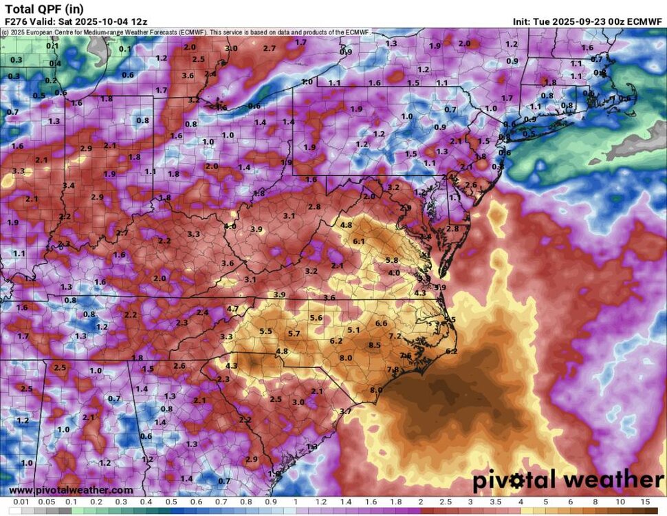
Thats if we dont get any tropical activity up here -
Wet pattern looks to develop end of the week and depending on any possible tropical system we could see some hefty rainfall totals into next week. Check the Euro, over 1 foot for much of NC. That being said, amounts could be drastically lower if the lead wave fails to develop or stays offshore
-
Ravens have a fumble problem. And since when does Lamar get sacked 6 times?
-

2025 Atlantic Hurricane Season
NorthHillsWx replied to BarryStantonGBP's topic in Tropical Headquarters
Really interesting forecast with our cherry and our orange. Several possibilities with regards to storm formation, intensity, which waves becomes dominant, and potential land impacts. The only real positive is if anything develops from the Orange and moved to the coast the environment looks prohibitive for significant strengthening with a lot of continental dry air and an ULL over the SE but I could definitely see a tropical storm impact if that waves gets going as that ULL could try to pull it westward. The cherry would likely remain ots if it develops. I think the evolution of each individual wave will impact the outcome of the other as they are not far apart and we may actually see a merger. Very volatile atmosphere right now with very low model consensus but I am becoming confident we get a storm between the two -
6z Euro

-
Also Lamar needs to have a better feel for when to stop trying to buy time to find an open receiver downfield and just throw the ball away or run- several times last night he had a wide open lane to take off and gain significant yardage and ended up taking a sack. His mom will be yelling at him this morning about that.
-
I will give it a go. Hopefully, some of the Nooga folks will chime in. Tough time of day to get a good grasp on. Afternoon storms are a risk in this pattern. Signal Mountain is also an entirely different ball game due to its elevation. If it is anything like my area here in TRI, modeling will often miss things above 1500'. Firstly, I am not a good short range summer weather source. I did check the RGEM, HRRR, and NAM 3k this morning for your local. I think what you shared is probably accurate. The RGEM is a hair earlier than 7PM. It is worth noting that modeling has been hit or miss with afternoon storms of late over E TN - i.e. not overly accurate. A lot of these lines and cells have been slow movers. By late morning or lunch today, if it were me...I would really keep an eye on short range, hi-res modeling which is derived from radar. The Signal Mountain NWS point and click is this for the entire day (25% from 4-7PM).... A 40 percent chance of showers and thunderstorms, mainly after 4pm. Partly sunny, with a high near 83. South wind around 5 mph becoming southwest in the afternoon.
-
Summer vibes today. Looks like 82/65 dewable imby.
-
They can still be a top team but there are things that need to change, and one of them is the rigid nature of the coach. The offense is fine and will get better if/when Ricard is back and Likely should be back against the Chiefs. Ofc Mitchell needs to play, but that goes back to my first point. The defense is just awful right now- partly injuries but they were bad before KVN and Madubuike got hurt. Probably wont happen, but I think Pagano should be promoted or have a bigger role in game planning. Looks like Henry might be on the edge of the aging RB cliff.
-

September 2025 OBS-Discussion centered NYC subforum
qg_omega replied to wdrag's topic in New York City Metro
Pattern still looks very dry next few weeks - Today
-
I think they very well could still win the division. But they clearly aren’t able to compete against other playoff caliber teams.
-

September 2025 OBS-Discussion centered NYC subforum
SnoSki14 replied to wdrag's topic in New York City Metro
Endless summer with 80s deep into October