All Activity
- Past hour
-
Not just boring. It’s been miserable trying to grow anything this summer.
-
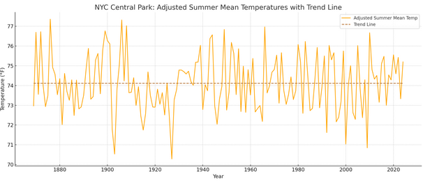
 My list was developed based on four criteria for which data is widely available: 1. Mean temperature 2. Highest maximum temperature 3. Highest minimum temperature 4. Number of 90F/32.2C or above high temperatures These values were standardized (standard deviations from the historic mean values for the period of record) I ran the numbers weighting each of the four criteria equally (initial approach) and also placing 50% weight on the mean temperature and then allocating the remaining 50% weight equally among the remaining three criteria. Further, I ran these numbers for a true summer (June-August) and extended summer (June-September) scenario. The different approaches were utilized based on various comments and "what if" questions made in the thread. If asked, I lean toward the second approach to weights (50% weight for the mean temperature as opposed to equal weights for all criteria) for the June-September period, as even relatively cool summers can have a short bout of extreme heat. Weighting everything equally skews the values. Separately, but not posted, I also looked at how much warming over the historic period has influenced summer mean temperatures. The coefficient of determination was 0.25, meaning that 25% of the variation in mean summer temperatures is explained by the ongoing warming and 75% is explained by internal variability. That's actually a quite high figure explained by warming, alone. Here's what summers look like at Central Park (1869-2024): Here's what they look like when the warming component is removed (as expected, the trend would be 0, but I included the trend line to illustrate that the warming was fully removed): In other words, here's what they would look like were internal variability, alone, responsible. Based on the data, Summer 2010 was just over 1.1F warmer than it would have been without the warming. Based on the internal variability, if a summer similar to 1876 occurs, the mean would be around 78.5F for the summer given the warming. It's probably a matter of time before the Summer 2010 figure is eclipsed (probably no later than the 2030s). Moreover, when it happens, the margin by which the record is broken could be fairly large, as one has seen elsewhere in recent years where summer records were broken.
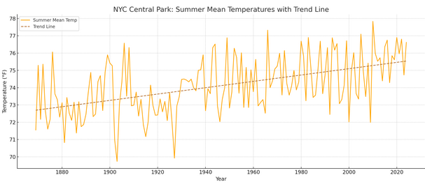
-
I ignore this forum for long periods when nothing of interest is happening so be happy. Starting drama for no reason is what is really boring.
-
Looking forward to temps in the mid 60s for the first day of classes on monday, will be a real shock after months of upper 80s and mid 70s dew down here
-
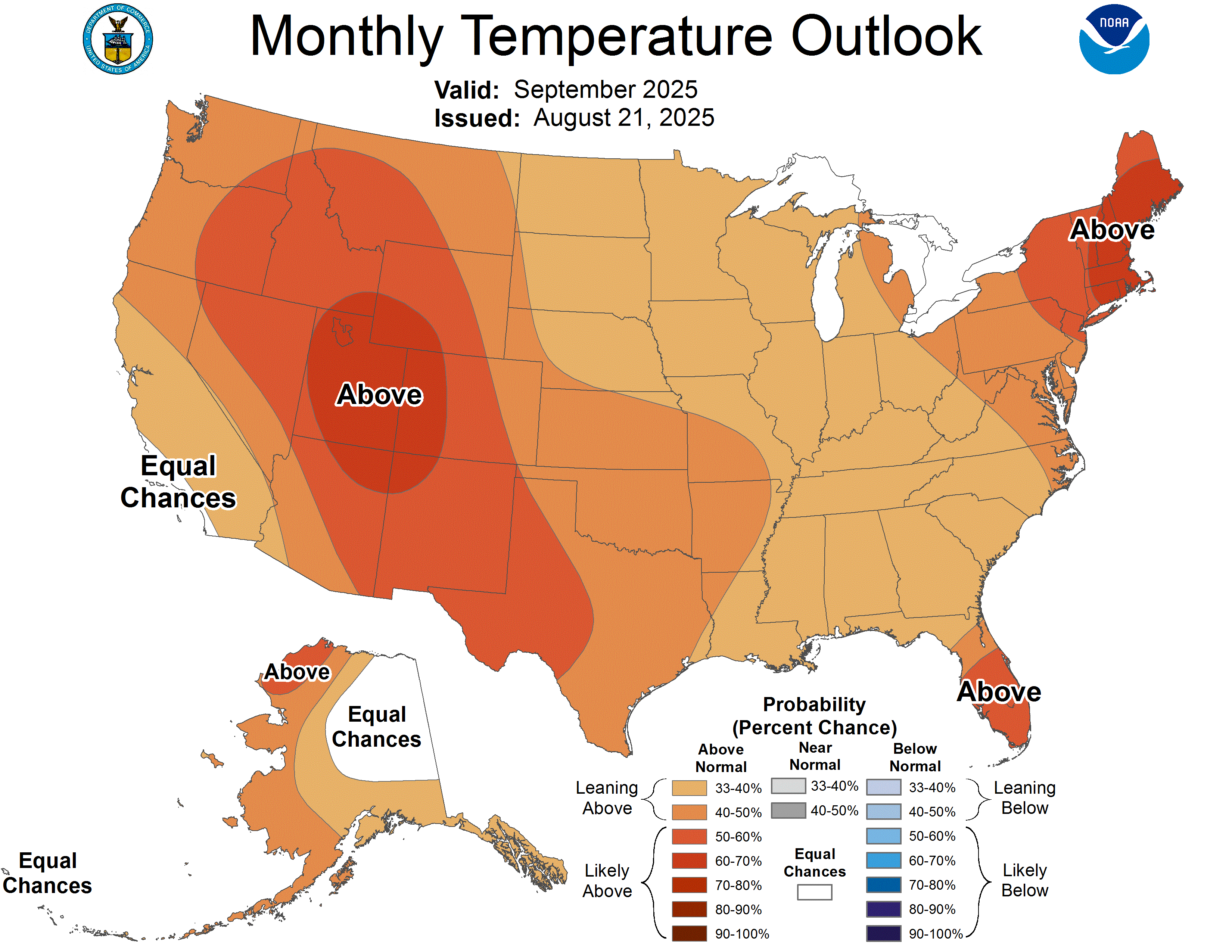
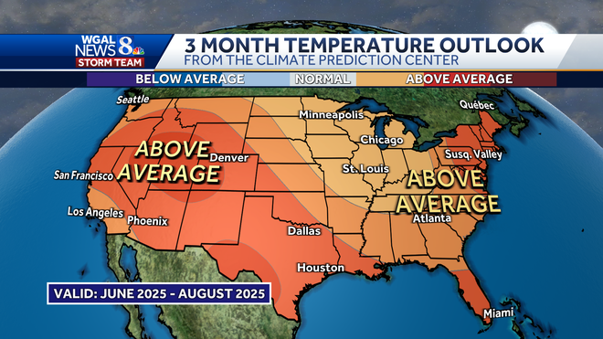
Here's what the CPC put out in May. We should end up slightly above average I think for the whole summer so not bad
-

Hurricane Erin: 105 MPH - 945 mb - NNE @ 17
Wannabehippie replied to BarryStantonGBP's topic in Tropical Headquarters
2:00 PM EDT Thu Aug 21 Location: 35.6°N 70.5°W Moving: NE at 18 mph Min pressure: 952 mb Max sustained: 100 mph -

Hurricane Erin: 105 MPH - 945 mb - NNE @ 17
GaWx replied to BarryStantonGBP's topic in Tropical Headquarters
Indeed, incorporating size, this is a MH. -

Hurricane Erin: 105 MPH - 945 mb - NNE @ 17
WxWatcher007 replied to BarryStantonGBP's topic in Tropical Headquarters
An immensely powerful hurricane -
You haven’t had lack of rain
-
Falmouth not so much
-
Same here. Usually, my site radiates better than yours - maybe a bit of breeze last evening here? Absolutely beautiful today, 73° when I got back from my knee-exercising walk at 3 PM, almost 3/4 mile - taking it bit by bit. Looked at what my new neighbors - 3 families, dad, 2 sons, families - have been doing this summer other than burning powder at the big (200' by 100') old logyard. Even at 800' thru the woods the noise is serious, though it's mainly 9 mm pistol. Only a few .223 cases and 12 ga. buckshot hulls, also 3 well shot-up pieces of plywood. Maybe they can push a deer to me while I'm sitting next the sled trail thru our woodlot this coming Nov.
-
Lack of rain and a couple cold nights will do that
-
 Yeah. I wish 287 had a scenic overlook to actually park my car and take a few pics. I guess in two months I'll see how this year compares to last.
 -

2025 Spring/Summer Mountain Thread
Maggie Valley Steve replied to Maggie Valley Steve's topic in Southeastern States
Mesoscale Precipitation Discussion 0966 NWS Weather Prediction Center College Park MD 243 PM EDT Thu Aug 21 2025 Areas affected...Southern Appalachians Concerning...Heavy rainfall...Flash flooding possible Valid 211845Z - 220045Z Summary...Slow moving showers and thunderstorms will expand across portions of the Southern Appalachians through this evening. Rainfall rates at times may reach 3"/hr which could overwhelm soils, especially in sensitive terrain. Flash flooding is possible. Discussion...The GOES-E experimental day-cloud phase micro-physics RGB this afternoon shows a rapid uptick in ice-bearing clouds suggestive of strengthening updrafts into Cbs from NW NC through central GA. These updrafts are associated with deepening convection, and there has been a recent uptick in lightning detection within these storms. This suggests that the environment is becoming increasingly favorable for thunderstorms containing heavy rain, as thermodynamics continues to intensify reflected by PWs measured by GPS between 1.6 and 1.9 inches, around the 90th percentile for the date, overlapped with MUCAPE as much as 3000 J/kg. Despite the relatively recent growth across the area, radar-estimated rainfall rates have already exceeded 1.5"/hr according to KGSP. As the aftn progresses, the CAMs are in decently good agreement in both coverage and placement of activity. It appears likely that convection will become widespread as PWs surge to above 2" outside of the higher terrain. This will support rain rates within thunderstorms that will likely exceed 2"/hr (HREF neighborhood probabilities above 30%) and may reach 3"/hr at times as reflected by HRRR 15-min rainfall above 0.75" in a few locations. Storms that develop will be of the pulse variety in response to limited bulk shear, but will also move very slowly on 0-6km mean winds of just around 5 kts. This indicates that despite the relatively short lifetimes expected of any individual cell, total rainfall could reach 2-3" in some areas, and this will be most likely where any boundary collisions, storm mergers, or terrain influences can impact the relative strength and motion of these storms. Soil moisture across the Southern Appalachians is generally well above normal as reflected by NASA SPoRT 0-10cm percentiles that exceed 98% in many areas. This has reduced 1-hr FFG to as low as 1-1.5" in some areas, for which the HREF exceedance probabilities peak above 25%. This is in addition to the general sensitivity across this area due to the terrain, as well as within any urban areas, so any slow moving thunderstorm could produce impacts due to flash flooding through this evening. Weiss ATTN...WFO...FFC...GSP...MRX...RNK
-
Now it's drizzling and raining. Is this shit ever going to clear out?
-

Mid to long range discussion- 2025
WinstonSalemArlington replied to wncsnow's topic in Southeastern States
How has this summer verified relative to the summer outlooks issued last spring? Did anyone predict this longrange? -

2025 Spring/Summer Mountain Thread
Met1985 replied to Maggie Valley Steve's topic in Southeastern States
Downtown Asheville is getting hit hard currently. -
 Sun is out, temps low 70s. I was hoping it would stay cloudy, oh well.
 -
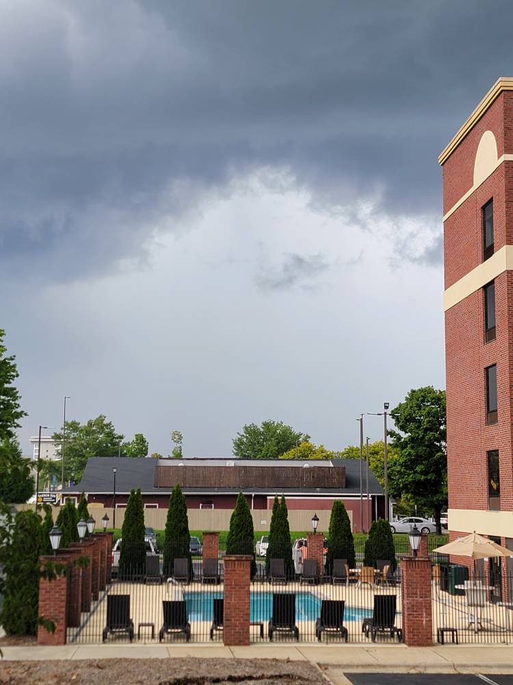
You and I have had this conversation before I remember this pic haha I think we concluded it was hit and miss depending on the area.
- Today
-
2025 Spring/Summer Mountain Thread
Met1985 replied to Maggie Valley Steve's topic in Southeastern States
Brevard rd at the Tanger outlets are fixing to get hammered. Sent from my SM-G998U using Tapatalk
-
Had my fracked yesterday and pushed up HP by 1/4 horse. Consistent 60 psi now. Frack rig weighed 40k lbs, very impressive operation.
-
Take the whole COC and deal with it.
-
Lots of chop
-
 It's 82° with crystally clear skies up here in Glens Falls right now.