All Activity
- Past hour
-
-
Idk. While the impacts in the Mid-Atlantic and northeast may be more mundane, I do think that the fact this is going to eventually interact with a shortwave as it pulls north is a red flag for inland areas that are on the eastern side of the center. That combo can be a prolific tornado producer. I also think we need to consider how this holds together inland. This is one of the areas where models like HAFS have been falling short. Now we see this being fairly well put together inland, and that means hurricane gusts could be possible well inland. From the 11am discussion in part: Weakening will occur after landfall, but sustained hurricane-force winds will likely occur near and along Isaias's track up to 100 miles inland from the coast into southern Alabama, and gusts to hurricane force could extend even farther north into central Alabama. Isaias is likely to lose its tropical characteristics by 36 hours when it is over northern Alabama.
-
JMA OCTOBER UPDATE **I think I rotated map too much, so actually the bottom needs to swing a little to the right. I think you'll see it makes a difference. Sorry about that. DJF DEC JAN **For individual months Jan is as far out as one can go until next month's update.
-
Hurricane Isaias Discussion Number 12 NWS National Hurricane Center Miami FL AL092026 1000 AM CDT Fri Oct 09 2026 An Air Force Reserve Hurricane Hunter aircraft currently investigating Isaias measured a peak 700-mb flight-level wind of 120 kt within the eastern eyewall a few hours ago, prompting an upgrade of the hurricane to major hurricane status with estimated surface winds of 105 kt. Based on the last several dropsondes released in the eye, the central pressure appears to have leveled off around 959 mb. On the last pass through the eastern eyewall, just about a half hour ago, the plane measured a flight-level wind of 111 kt, suggesting that the peak winds may have also leveled off. The eye itself has become cloud filled in visible satellite imagery, but it is now moving into range of several WSR-88D radars along the northern Gulf coast. Strong deep-layer shear has definitely increased as forecast, with various analyses now showing 30-40 kt out of the southwest. However, the shear vector is nearly aligned with the storm's motion, which limits its adverse effects, and upper-level divergence is also increasing over the hurricane. This setup has likely allowed the hurricane to intensify this morning, and the hurricane regional models (HAFS-A, HAFS-B, and HWRF), as well as the statistical-dynamical models (SHIPS and LGEM), all suggest that Isaias could maintain major hurricane intensity up until its landfall this evening. Therefore, the NHC official forecast depicts Isaias with 100-kt winds just offshore the western Florida Panhandle this evening. Weakening will occur after landfall, but sustained hurricane-force winds will likely occur near and along Isaias's track up to 100 miles inland from the coast into southern Alabama, and gusts to hurricane force could extend even farther north into central Alabama. Isaias is likely to lose its tropical characteristics by 36 hours when it is over northern Alabama. Aircraft fixes indicate that Isaias has drifted a bit east of the previous forecast track. NHC's track forecast leans on the eastern side of the guidance envelope, closest to the latest HCCA and GDMI guidance, and implies a potential landfall along the extreme western Florida Panhandle coast this evening. After moving inland, the center of Isaias is expected to continue northward through Alabama, before turning northeastward over the Tennessee and Ohio Valleys (as a post-tropical remnant low) on Sunday. Now that the eye has become visible in WSR-88D coastal radars, hourly Tropical Cyclone Updates will be issued beginning at 11 AM CDT (1600 UTC). Key Messages: 1. A life-threatening storm surge is expected from the Mouth of the Mississippi River to Suwannee, Florida. Residents under evacuation orders should leave immediately and follow advice from local officials. 2. Extremely dangerous and damaging hurricane force-winds are expected over portions of the Florida Panhandle, southern Alabama, and southern Mississippi where a Hurricane Warning is in effect. Residents in these areas should have a safe room to ride out the storm and prepare for long-duration power outages. 3. Damaging wind gusts are likely over a large portion of the southeastern United States from western and northern Georgia westward over much of central and northern Alabama, southern middle Tennessee, and Mississippi, especially in areas of higher terrain. Residents should secure loose outdoor items, avoid driving high-profile vehicles, prepare for power outages, and be aware of the potential for falling trees. 4. Isaias will bring areas of heavy rainfall to the central U.S. Gulf coast and much of the Southeast through the weekend. Considerable flash and urban flooding, and significant river flooding, are possible. 5. The tornado potential will increase this afternoon and continue through tonight. The greatest risk will be east of the center, particularly across the Florida Panhandle into southern Georgia. This risk will continue spreading north-northeast across parts of the Southeast on Saturday. FORECAST POSITIONS AND MAX WINDS INIT 09/1500Z 27.7N 87.3W 105 KT 120 MPH 12H 10/0000Z 29.7N 86.8W 100 KT 115 MPH 24H 10/1200Z 32.1N 87.1W 55 KT 65 MPH...INLAND 36H 11/0000Z 34.2N 87.2W 35 KT 40 MPH...POST-TROP/INLAND 48H 11/1200Z 36.5N 85.0W 25 KT 30 MPH...POST-TROP/INLAND 60H 12/0000Z 39.1N 81.0W 20 KT 25 MPH...POST-TROP/INLAND 72H 12/1200Z...DISSIPATED $$ Forecaster Berg
-
BULLETIN Hurricane Isaias Advisory Number 12 NWS National Hurricane Center Miami FL AL092026 1000 AM CDT Fri Oct 09 2026 ...CENTER OF ISAIAS EXPECTED TO REACH THE WESTERN FLORIDA PANHANDLE COAST THIS EVENING... ...LIFE-THREATENING STORM SURGE AND DEVASTATING WINDS LIKELY ALONG THE FLORIDA PANHANDLE AND ALABAMA COASTS... SUMMARY OF 1000 AM CDT...1500 UTC...INFORMATION ----------------------------------------------- LOCATION...27.7N 87.3W ABOUT 195 MI...310 KM S OF PENSACOLA FLORIDA ABOUT 145 MI...235 KM SE OF THE MOUTH OF THE MISSISSIPPI RIVER MAXIMUM SUSTAINED WINDS...120 MPH...195 KM/H PRESENT MOVEMENT...NNE OR 25 DEGREES AT 16 MPH...26 KM/H MINIMUM CENTRAL PRESSURE...959 MB...28.32 INCHES
-
Recon shows this has either peaked or leveled off. NHC noted they now expect a major at/just before LF
-
That, and the fact I can only pronounce it correctly 1 out of every 10 tries.
-
Question... when the give the position of a storm... if the position the exact middle of the eye?
-
you should start Penix, and then the football gods, to spite you, will allow Daniels to have an incredible game leading to a Commanders win.
-
It's still a tropical entity that will bring an influx of moisture. I could see 2-3" amounts.
-
It’s really hard to project below normal snowfall south of the pike. If there was a year that would be a candidate, it would be this one. However, the entire winter could be a rat on balance, but all it takes is one storm. Places around Fall River got an entire seasons worth of snow in one event last year. You just can’t predict that type of variance. It literally could only take one storm. Id guess Boston points south can set the snooze button for most of the winter though. Background climate state screams a lot of elevated interior events, and more than likely deep elevated interior, like NNE. Im not optimistic here, but we had 2 really good events last year, so it is what it is.
-
Wow @CoastalWx chiming in on AmrWx somewhere else than the New England forum and the sports threads? Be still my beating heart! Guess he has to breakup this "boring" pattern somehow!
-
This name should’ve been retired in 2020 after what it did to SOMD.
-
It will be like a typical non-tropical low pressure once inland, like a Miller A storm. Atlanta has been through this many times. The problem is media hype and knee-jerk reactions from authorities end up resulting in overdoing the cancellations and shutdowns. Just b/c this storm has (had) a name on it, does not make it different overall once it goes PT/ET and for locations far inland, yes there are exceptions, like Helene, but that's not the case here. Many PT/ET storms out of the Gulf have produced the same impacts to the SEUS as Isaias will. I posted earlier about the Gulf storms in Oct 1992 and 1994. You watch, the ET part of Isaias is going to impact the entire E Coast. It will be no different than typical Nor'easter and not even as strong or impactful as the Nor'easter last month, say DCA-BOS. but it will be treated as "worse" b/c it was a former hurricane and you'll see unnecessary cancellations for it. There is no scaling or quantification of wx events these days, all are the same as to being worst ever, unprecedented, or absolute high-end events as to impact that we all have to hide and cower in fear from. Being constantly "held hostage" by the wx is not a good thing. esp for business and commerce. You can't hide behind the excuse "better safe that sorry" for every single wx situation. This mindset has real impacts. The door swings both ways here.
-
You’d think with ticket prices these resorts would be throwing the latest and greatest everything all over the mountain
-
My calf is fully healed, but not sure how much I’ll get out this year. Having a new child, has $4.50 a gallon, and lift tickets are a partial mortgage payment now. Would like to get out a couple times, but not sure it’ll be in the cards.
-
 can gabapentin cause sleepiness: Neuro Relief Direct - gabapentin pulse rate
 -
Unfortunately I don't think its going to be dry.
-

October 2026 General Discussion
hawkeye_wx replied to SchaumburgStormer's topic in Lakes/Ohio Valley
The good storms missed southwest, but I got a few rumbles and 0.48" of rain. Up until last evening, I did not know rain was even in the forecast. This weekend looks very warm, possibly getting into the 80s. Next weekend looks very chilly, first with strong nw wind and then possibly our first frost or even freeze. -
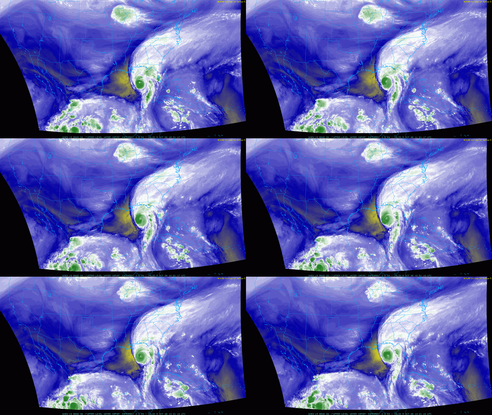
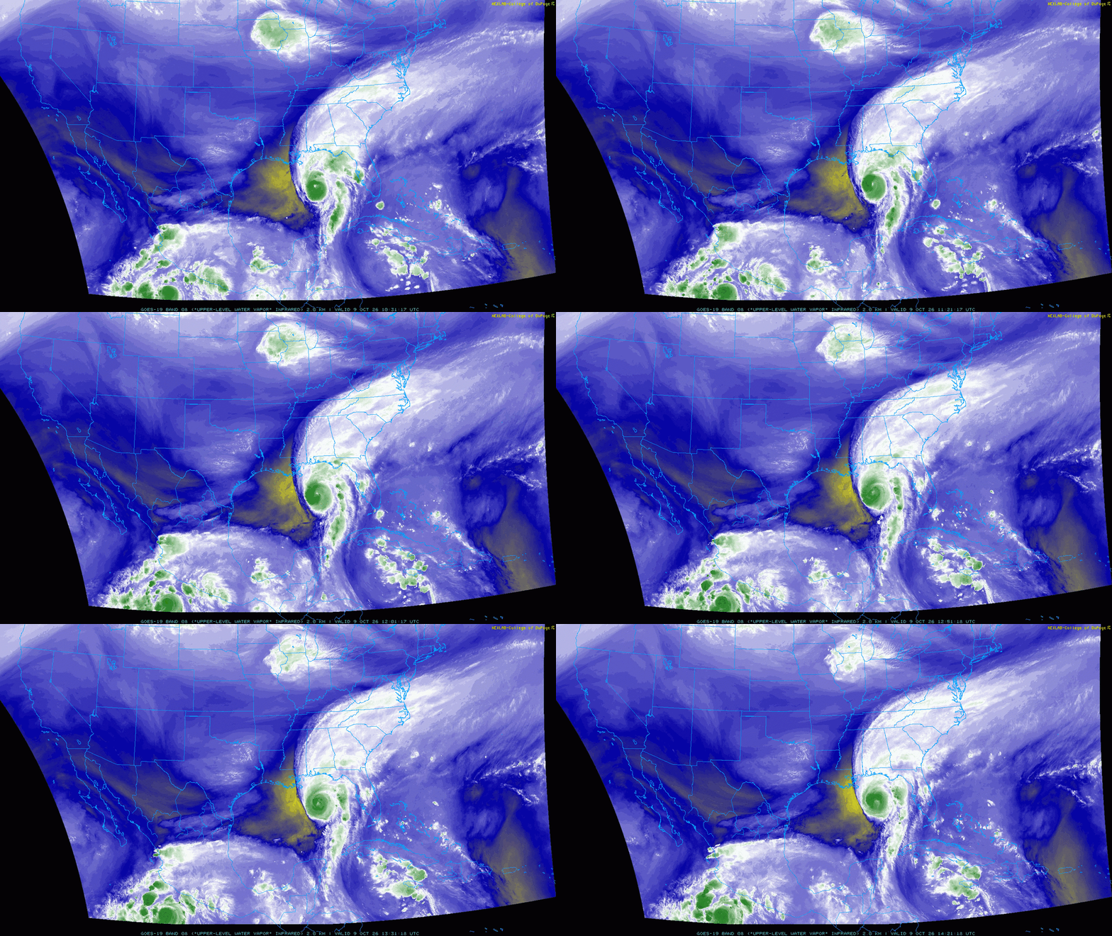
The models were pretty insistent that Isaias would be able to gradually deepen and improve structurally through most of the day today as long as it stays on a NNE heading, with shear and dry air likely to rapidly begin affecting the inner core in the last few hours before landfall as the storm's heading starts bending more towards the left/due north. The strong west-southwesterly shear and very dry mid-level air are definitely impinging on the core of Isaias this morning, but convection has continuously wrapped around the upshear side of the storm and is insolating the core from this unfavorable environment for now as a shortwave approaches from the west. With the storm over very warm waters and beneath enhanced upper-level divergence ahead of the shortwave it can continue to gradually intensify/deepen. With a very intense convective burst ongoing in the NW eyewall right now, we probably have one more burst of intensification into the afternoon. The shear will increase further in a few hours and the storm motion will become less parallel to the shear vector this evening, so it remains likely the unfavorable environment starts affecting the inner core as landfall approaches. Per the regional hurricane models the inner core may break down pretty quickly tonight right around the time of landfall, though with a bit more near-term intensification and only a few hours for the environment to negatively affect Isaias this evening before landfall my guess is landfall occurs with a peak wind between 90-100kt, with the wind field beginning to expand by then due to interaction with the incoming shortwave.
-

2026-2027 Fall/Winter Mountain Thread
wncsnow replied to BlueRidgeFolklore's topic in Southeastern States
Sure looks like this will be our heaviest rain event since Helene along the escarpment. I just wonder if there will be any new landslides where the soil is still loose from last time. -
Question for @Sey-Mour Snow @weatherwiz @CT Rain How much would CT benefit from having its own mesonet? Does being a small state cut against its need? I know we already have several airport stations around the state, but would a mesonet aid in long term data collection and forecasting in a way that would outweigh the cost of setup and maintenance?
-
Wow, what a complete turnaround overnight in the last 12 hours. Isaias was looking very ill organized about 10 hrs ago, but I am impressed this morning. Unfortunately, this obviously increases the chances for more severe impacts at the coastline. That radar from Mobile shows quite a nasty eyewall. Here is hoping it weakens in the next 12 hrs, but now the NHC sounds less sure that this wont make landfall as a major hurricane.
-
Picked up 0.10" of Iowa's scraps early this morning.
-
Nam is mid morning now