All Activity
- Past hour
-
That post is incorrect.
-

January 2026 regional war/obs/disco thread
Ginx snewx replied to Baroclinic Zone's topic in New England
Lol when I was 7 in 1964 in mid winter it rained with an offshore track. Do some research before you post. -
It'll be much more interesting once we get into next week. 5 days out is my magic number. Things look good but we've been burnt recently.
-

January 2026 regional war/obs/disco thread
brooklynwx99 replied to Baroclinic Zone's topic in New England
lol you know you can get rain when a benchmark track now, right? and like 10 years ago? where do these people come from -
That MEI number is proof of a very well coupled (ocean-atmosphere) La Niña
-
Nice increase on the EPS ensembles over the last 48 hours (thru the same end time). We're finally starting to see some snowstorms pop up and disappear, but that's better than nada we've had for awhile.
-
What 18z run did u look at! Lol
-
Very nice!!
-
Like I said, you don't understand. Google/AI might be helpful.
-
The 18z ICON at 120hr isn't going to phase as much of the southern stream into the longwave trof as 12z. Kind of a bummer, but not surprising since it has so little support. It still looks better than the GFS, for example, but it's a little more evidence that the best model outcome is probably wrong.
-
It’s been a minute since I’ve seen pinks on any clown map around here
-
I’ve been looking as DC’s 5 day forecast on Google all this week. At the start of the week it showed Saturday reaching 66, a day later it was down to 62, and now it’s not even going to make it out of the 50s.
-
Holy hell! Help me with a GFS bomb for happy hour. I can’t freakin see….
-

January 2026 regional war/obs/disco thread
Krs4Lfe replied to Baroclinic Zone's topic in New England
Until the warmth from the CC outpaces the cold and you end up with rain from a benchmark track. That is coming sooner than we think -
Yeah made it to low 50s in NYC as well. We’re torching quite well this week. Seems like we’ll be back into colder weather by Monday, 1/12. This will definitively erase our colder than average start to the month
-
The pulses of winds aloft then descending during that storm were insane. I believe that led to the hole in RI all that air rose over EMA sunk and dried quickly in RI then rose and as quickly condensed in CT. Probably one of the most anomalous storms of my life. I mean 14 here while 4 just 3 miles to my east which is over 750 feet altitude and usually gets more than me on 850 east flows.
-

2025-2026 Fall/Winter Mountain Thread
Maggie Valley Steve replied to Buckethead's topic in Southeastern States
Looking like we're going to get some beneficial rain tomorrow and especially Saturday ahead of the cold front. The Northern Mountains could see some flow snow late Saturday night into Sunday. Next week looks real interesting regarding any possibility of wintry weather particularly from the 15th going forward! -
53 here today after a low of 28.
-

January 2026 regional war/obs/disco thread
ORH_wxman replied to Baroclinic Zone's topic in New England
SE ridge with frigid cold to the north always makes those more likely but you can easily get high-QPF snow events too in that. -

January 2026 regional war/obs/disco thread
Go Kart Mozart replied to Baroclinic Zone's topic in New England
Icy setup? Pingy? -
January 2026 regional war/obs/disco thread
ORH_wxman replied to Baroclinic Zone's topic in New England
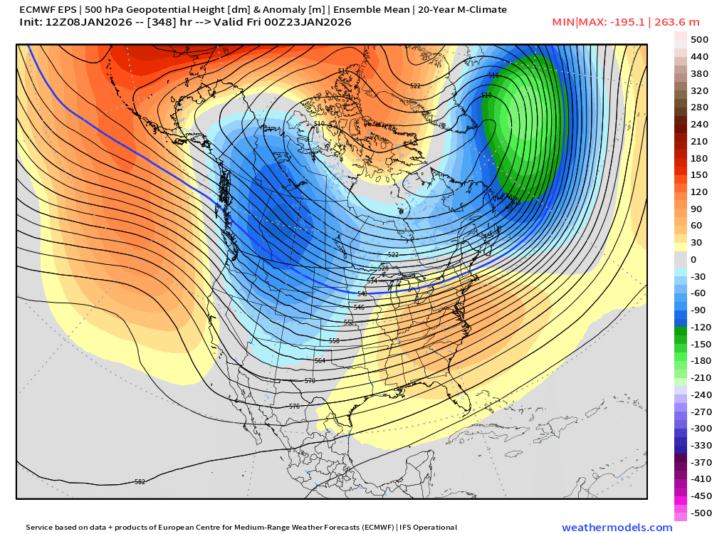
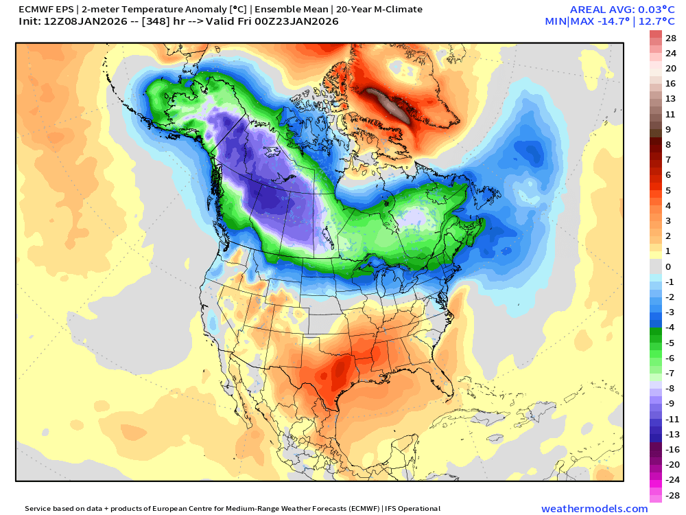
It's been a pretty big switch this year with the WPO keeping on wanting to revert to a big negative phase. Last year, we were able to break the streak of it being largely positive, but it was still not strongly negative....it was enough with the -EPO to give us slightly BN temps. But this year, we had a raging -WPO much of December, and even when it flipped early here in January, it quickly wants to set up shop again next week. -
Except for UK, GFS, GFS-AI, ECM-AI, and GEFS.
-
Just impossible to put any faith in the models anymore.
-
Obviously this is a far stretch but it shows the potential if everything goes right.
-
January 2026 regional war/obs/disco thread
ORH_wxman replied to Baroclinic Zone's topic in New England
A little bit of Wilton on that look late in the game (after maybe a few shots at a coastal in the D10-13 range)....some people might get a little scared of the orange colors at H5 getting close to NE, but that is a frigid northern tier look with that WPO/AO domain look.