All Activity
- Past hour
-
 It’s tough when Canada is having record heat and drought and they keep getting all these lightning strikes. https://www.cbc.ca/news/canada/british-columbia/bc-wildfires-1.7599568 BC’s fire season is surging as the number of active wildfires more than doubled from 61 on Thursday to 134 by Friday morning, according to the B.C. Wildfire Service (BCWS). The service says the surprising increase in fires can be attributed to the more than 35,000 lightning strikes on July 30 and 31 — with even more expected, as severe thunderstorm watches remained in place on Friday for a large swatch of the southern Interior and stretching into locations in the northeast.
 -
It’s the GFS, so take it with a grain of salt.. https://x.com/lockingitin/status/1952375266569064644?s=61
-
Meanwhile in Australia https://www.facebook.com/Reuters/videos/2560754497605762/?mibextid=rS40aB7S9Ucbxw6v
-
Pretty ugly smoke. Not too bad along the CT shore though.

-
Shadows look weird when the light is diffused by the smoke like this.
-
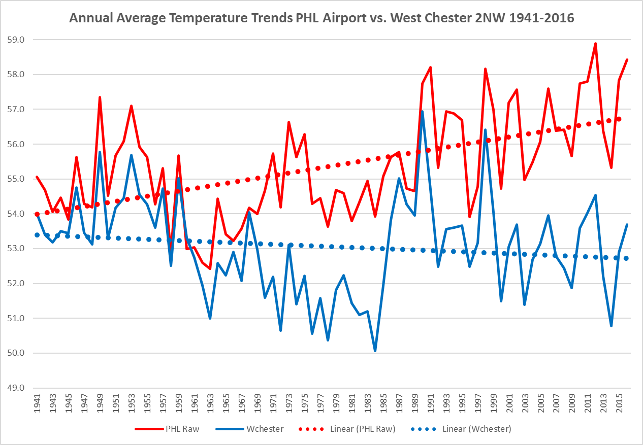
 Another long term climate site - West Chester 2NW vs PHL Airport 1941 - 2016 West Chester cooling while PHL of course off to the warming races
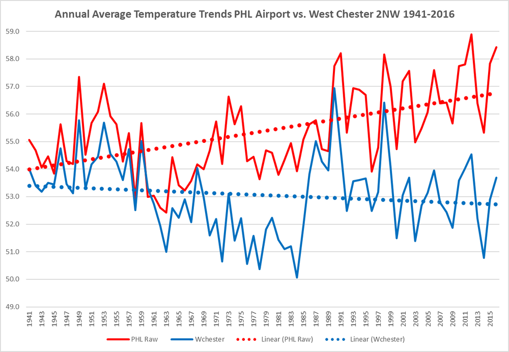
-

Occasional Thoughts on Climate Change
TheClimateChanger replied to donsutherland1's topic in Climate Change
In a stunning departure from the conditions of the summer to date, August has started off on a very cool note nationwide. The PRISM data below is only for the first two days of the month, but yesterday saw similarly impressive cold with a number of record low max temperatures in the south and a few isolated record lows in the eastern US. While I still expect August to finish out above normal for CONUS, this is going to make a new summer national record quite difficult. Will probably take a few days just to return to 1991-2020 means nationally, which means we are likely looking at one of the coolest first weeks of August in a long while. Probably would need an epic heat wave to keep pace with 2021 & 1936, at this point. -
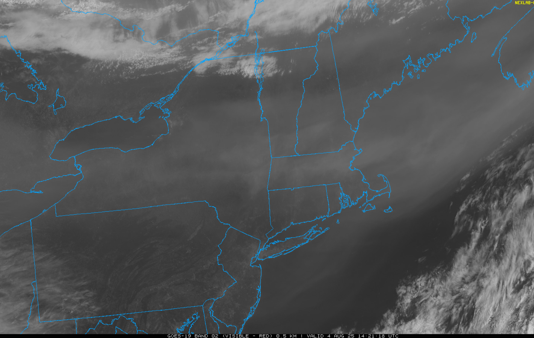
 I guess instead of cold or warm fronts now, we have smoke fronts.
 -
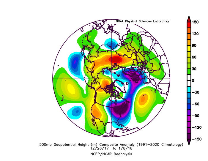
Here was a post I made elsewhere on 1/7/2018 about it being the coldest 7 days in my area since Jan of 1977: SAV just experienced its coldest 7 consecutive days in 41 years, its first below 32 F week in 28 years, and a tie for its 8th coldest since records started in the 1870s! The longevity of this cold is one for the ages. 10 SAV weeks at or colder than 32 F starting from coldest: - 1/1886 - 12/1917-1/1918 - 2/1895 - 1/1977 & 1/1970 tied - 2/1899 - 1/1887 - 1/2018 & 12/1901 tied - 12/1989 Only 4 of these 10 weeks have occurred during the last 100 years! By the way, the snow & ice remain largely intact in shady areas and we're over 4 days after it ended! I still have one icicle! 1/8/18 edit: Note that this long duration cold occurred despite a +NAO. It was supported by a +PNA/-EPO combo as well as a -AO when averaged out.
-
Lots of smoke around.. i don't think I've seen it this bad yet this year
-
2nd worst air quality in the world for Toronto following the smokiest July on record in Winnipeg.
-
Coc ks man. Coc ks
-
Nasty day in se nh. Who wanted this and why?
-
 Wait, you live on Long Island?
 -

2025 Lawns & Gardens Thread. Making Lawns Great Again
BrianW replied to Damage In Tolland's topic in New England
@dendrite Just watched this and remember you were growing Chestnuts. Apparently there's 4 trees that seem to be blight resistant so there is hope of bringing them back. https://www.ctpublic.org/shows/human-footprint/clip/the-ghost-tree-bringing-back-the-american-chestnut-mzwjuw -
Except it does not!! Clearly PHL Airport see below is warming much faster due to the UHI at the airport
-
Heading to the Andrea tomorrow.
-
 The best fishing around here is during the colder months. April-June and then October through December.
 -
Those aren’t the people who “love” fishing. Those are casuals.
-
https://phys.org/news/2025-08-plastic-pollution-grave-health-threat.html
-
mm...starting to smack like the high temperatures today will take a hit because of smoke.
-
Beautiful stretch. At PIT, we've doubled our July tally of low temperatures below 60F in the first four days of the month. Happy I've been able to give the A/C a rest for a change.
- Today
-
The most significant cold in my area over the last decade was 12-26-17 to 1-8-18. It was mostly Pacific driven. This is why my comment about other factors having a greater influence on the Northeast temperatures than the NAO. You can see the generally lower heights over Greenland to Iceland. The best blocking was over Western North America. Time Series Summary for NY CITY CENTRAL PARK, NY 10 coldest 12-26 to 1-8 periods on record Click column heading to sort ascending, click again to sort descending. 1 1918-01-08 13.4 0 2 2018-01-08 17.9 0 3 1904-01-08 20.6 0 4 1881-01-08 21.9 0 5 1879-01-08 22.2 0 6 1887-01-08 22.4 0 7 1981-01-08 23.7 0 8 1940-01-08 23.9 0 9 1968-01-08 24.2 0 10 1877-01-08 24.6 0
-
I just looked at the national weather map and hadn’t realized how bad the smoke was in the northeast and around the Great Lakes.
-
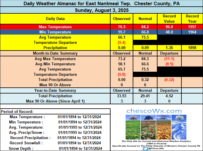
The first 3 days of August have featured temperatures nearly 10 degrees below normal. We see temperatures rebound this PM to near normal with highs in the low to mid 80's. Similar temperatures tomorrow before we turn again a few degrees below normal to close out the work week. Near normal temperatures return next weekend. Rain chances look slight but more clouds and maybe a shower on Wednesday.