All Activity
- Past hour
-
A washout of a Halloween though.
-
The surface center is leaving the convection behind again this morning.
-
I might try Canaan valley state park. Easier to access and the road is generally in decent shape. Black bear has some decently priced suites that are pretty cool also.
-
What do you think the best place is for upslope hiking wise? I’ve been at spruce knob before but I don’t know if I’d want to try that road when it’s snowing.
-
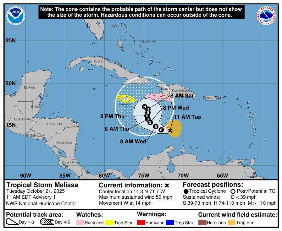
Tropical Storm Melissa Discussion Number 1NWS National Hurricane Center Miami FL AL1320251100 AM EDT Tue Oct 21 2025Satellite images, regional Caribbean radar data, and surface observations indicate that invest 98L has developed a well-defined center and organized deep convection to be designated a tropical cyclone. A ship report that recently passed near the center of the system reported a minimum pressure of about 1003 mb. Satellite imagery shows the system is asymmetric, with the low-level center near the western edge of the central dense overcast. The initial intensity is set at 45 kt, based on a blend of the latest satellite intensity estimates, marking the formation of Tropical Storm Melissa. An Air Force Hurricane Hunter aircraft is scheduled to investigate the system this afternoon, and their data should provide a better assessment of Melissa's strength and structure. The system was moving very quickly westward over the past several days, but it has slowed down significantly this morning, which has likely helped Melissa form. The initial motion is estimated to be 280/12 kt. Melissa should continue to slow down and gradually turn to the northwest and then north during the next couple of days toward a weakness in the subtropical ridge. This motion will likely take the storm very near the southwestern tip of Haiti and Jamaica by Thursday. After that time, the guidance diverges significantly with some models like the GFS and HWRF showing a motion to the northeast into the weakness, while the other solutions show a stall or a westward drift on the south side of a building ridge. An examination of the GFS, ECMWF, and Google DeepMind ensemble suites suggest that the majority of the members show Melissa not moving into the weakness and remaining in the Caribbean Sea throughout the week and into the weekend. The NHC official track forecast lies between the Google DeepMind ensemble mean track and the correct consensus aid, HCCA.Melissa is expected to be over the very warm waters of the Caribbean, but the models suggest that vertical wind shear will be moderate with some dry air in the vicinity of the storm during the next few days. Based on these mixed signals, the strengthening trend is expected to be slow and steady, not rapid. However, the future intensity of Melissa is linked to the track and since that is quite uncertain beyond a couple of days, the strength of the storm is also quite uncertain. The NHC intensity forecast is in best agreement with the HCCA model.Key Messages:1. Melissa is expected to bring heavy rainfall and the risk of significant flash flooding and the danger of landslides to portions of Haiti and the Dominican Republic through the weekend.2. A Hurricane Watch has been issued for the southern coast and Tiburon peninsula of Haiti. A Tropical Storm Watch has been issued for Jamaica. Preparations to protect life and property should be completed by Thursday.3. There is significant uncertainty in the track and intensity forecast of Melissa. Interests elsewhere in Hispaniola and Cuba should continue to monitor the latest forecasts.FORECAST POSITIONS AND MAX WINDSINIT 21/1500Z 14.3N 71.7W 45 KT 50 MPH12H 22/0000Z 14.4N 72.8W 50 KT 60 MPH24H 22/1200Z 14.8N 73.5W 55 KT 65 MPH36H 23/0000Z 15.3N 74.2W 60 KT 70 MPH48H 23/1200Z 15.7N 74.5W 60 KT 70 MPH60H 24/0000Z 16.1N 74.6W 60 KT 70 MPH72H 24/1200Z 16.5N 74.5W 60 KT 70 MPH96H 25/1200Z 16.9N 74.5W 65 KT 75 MPH120H 26/1200Z 17.2N 74.9W 70 KT 80 MPH$$Forecaster Cangialosi/Bucci
-

Spooky Season (October Disco Thread)
CoastalWx replied to Prismshine Productions's topic in New England
Where's the blocking? Hudson bay to Quebec ridging on EPS then moves to a more +NAO. Pacific gets a little better...might allow a decent cold shot early November. -
It looks like most places in North Carolina outside of the immediate coast and CLT and the southern Piedmont and GSO have gone below 40 this season.
-
-
-
Yep, BUT figuring out how to win being down 10 with 8-9 minutes left in the game does say something. I KNEW there was no way UVA was gonna cover a 17 point spread lol. If you are/were a betting person that was an EASY pick, to not cover. Wa ST isn't a bad team, I can see them going 7-5 and bowling with their remaining schedule, heck they almost pulled off a win at then #4 Ol Miss the week before.
-

Mid to long range discussion- 2025
WinstonSalemArlington replied to wncsnow's topic in Southeastern States
GFS is later with the big cold, but still doesn’t deny it’s comingg -
Plentiful 30s this morning in North Carolina
-
Spooky Season (October Disco Thread)
CoastalWx replied to Prismshine Productions's topic in New England
I know of WindBorne. When I heard about what they do, this thought went through my mind. That’s wild. -

Spooky Season (October Disco Thread)
dendrite replied to Prismshine Productions's topic in New England
Chemtrail right through the windshield -
Winston got down to 39 this morning, but GSO only got down to 42.
-
.thumb.png.4150b06c63a21f61052e47a612bf1818.png)
Spooky Season (October Disco Thread)
HIPPYVALLEY replied to Prismshine Productions's topic in New England
Looks like boredom until the Christmas week screaming Sou'Easter -
Spooky Season (October Disco Thread)
HIPPYVALLEY replied to Prismshine Productions's topic in New England
The old weather balloon excuse, right out of the Roswell playbook... -
Mid to long range discussion- 2025
WinstonSalemArlington replied to wncsnow's topic in Southeastern States
Rumors of a Sandy redux may be exaggerated, but something big is brewing around Halloween and All Saints Day. - Today
-
11 hours too late for my forecast but them’s the breaks.
-

Spooky Season (October Disco Thread)
Damage In Tolland replied to Prismshine Productions's topic in New England
Wish the Euro/ EPS had something -
Local media and social media pundits are banging the "cold and snowy" drum; with a lot of comparison to 2013-14. Would def take the Dec/Jan of that season again.
-
Spooky Season (October Disco Thread)
dendrite replied to Prismshine Productions's topic in New England
That’s pretty wild -

Monday, October 20, 2025 Squall Line Potential
tamarack replied to weatherwiz's topic in New England
0.79", with about half coming from a 5-minute downpour in mid afternoon. Eight miles WNW, West Farmington cocorahs reported 1.42". They must've had 10-15 minutes in the RA++. -
http://AO PV Blog Summary The Arctic Oscillation (AO) is currently negative to near neutral and is predicted to oscillate around neutral and possibly go negative again the next two weeks as pressure/geopotential height anomalies across the Arctic are currently mostly mixed and are predicted to remain mostly mixed to mostly positive the next two weeks. The North Atlantic Oscillation (NAO) is currently negative as positive pressure/geopotential height anomalies dominate across Greenland, and the NAO is predicted to oscillate around neutral the next two weeks as pressure/geopotential height anomalies are predicted to mostly mixed to positive across Greenland. The next two weeks, weak ridging/positive geopotential height anomalies across Greenland will support transient troughing/negative geopotential height anomalies downstream across much of Europe. The progressive flow pattern will support normal to above normal temperatures across Europe including the United Kingdom (UK) with a brief flip to normal to below normal temperatures first across much of Europe including the UK next week. Ridging/positive geopotential height anomalies are predicted to dominate Asia with the exception of troughing/negative geopotential height anomalies across Eastern Asia the next two weeks. This pattern favors normal to above normal temperatures across most of Asia with the exception of normal to below normal temperatures regionally across Eastern Asia the next two weeks. The general predicted pattern across North America the next two weeks is widespread ridging/positive geopotential height anomalies centered on Eastern Canada with troughing/negative geopotential height anomalies along the west coast of North America and the Eastern United States (US). This patten will favor widespread normal to above normal temperatures across Alaska, much of Canada and the US with the exceptions of normal to below normal temperatures in the Eastern US this week and then next week normal to below normal temperatures will sweep into the West Coasts of Canada and the US and then eventually in the Eastern US. I continue discussing my thoughts about the upcoming pattern across the Northern Hemisphere (NH) and continue with some preliminary predictors for the upcoming winter polar vortex (PV) and weather. Plain Language Summary So far for October, it is a tale of two continents, extremely mild in North America and fairly widespread cold across Eurasia, especially in Southeast Asia, Siberia and focused now in Mongolia (see Figure). It has also been chilly in Central Asia and in Europe, especially in Southeast Europe (see Figure). No joke but Mongolia has the most resilient winter weather in the Northern Hemisphere. It has been a forgettable month of October for me here in Boston but at least for me the cold is where it should be in October. And the forecast can be summarized as mild weather reigns supreme (see Figures 3, 6 and 9). Longer term Greenland blocking could become established in early November that could finally bring cooler weather to North America and re-establish some colder weather across northern Eurasia. I am also closely watching the snow cover advance across Siberia this month, a rapid advance suggests a more severe winter and a slower advance a milder winter.
-

Spooky Season (October Disco Thread)
powderfreak replied to Prismshine Productions's topic in New England
Not every day a passenger jet smokes a weather balloon… https://onemileatatime.com/news/united-boeing-737-hit-weather-balloon-cracking-windshield-bruising-pilot/?fbclid=IwZXh0bgNhZW0CMTEAAR5AqWqARKi7Vtyd8XP1QnL6YIpIPy3yxK1sQL2Bkk4Q9Dm78GXKB2kgWqDzGw_aem_nQyt_Obm5uU4t4q4YpI1cg


