All Activity
- Past hour
-
EPS trend gif would help visuals
-
Threads created for this weekends storm. .
-
2025-2026 Fall/Winter Mountain Thread
CheoahBald1 replied to Buckethead's topic in Southeastern States
BAM weather is dying for a NW trend , you can tell he is bias for the north lol . -
https://x.com/burgwx/status/2013321433670144421?ct=rw-null .
-

Rise of the Machines: January 18-19 Winter Storm Obs Thread
vortex95 replied to WxWatcher007's topic in New England
So you got your 6" and that breaks the 6" drought for Weymouth. Happy dayZZZZZZZZ are here again!? LOL. I don't want to hear it from you anymore. This winter is turning out pretty good now, esp, since we just filled the "snow hole" area in parts of RI and ern MA and given recent winters. And it will be *preserved* well for the next week being so cold except Thu, but some melting will actually be good b/c it will refreeze *hard* into a glacier block. Have lemons, make lemonade! But wishful thinking? CoastalWx already I bet: "The pseudo-Miller A this weekend will miss SNE and may give Norfolk VA its all-time record snowstorm. Why can we get that here???!!!" -
good sign: https://bsky.app/profile/wxmvpete.bsky.social/post/3mcril3p4522p
-
The hesitancy of NWS-Nashville and NashSevereWx...I don't get it. Their downplaying of the weekend event is irking me.
-
Thursday's model runs will be the make or break for guidance. Most of the players will be within the upper air network in North America, and I'd be my bottom dollar that NOAA will be running extra planes for data sampling.
-
Lord…. .
-

January 2026 regional war/obs/disco thread
dendrite replied to Baroclinic Zone's topic in New England
These can be deals where you get a big fronto band on the northern edge (convergence/stretching of parcels) so I wouldn’t count us out yet. -
There's a chance
-

Central PA Winter 25/26 Discussion and Obs
Jns2183 replied to MAG5035's topic in Upstate New York/Pennsylvania
This winter like most winters I would prefer to be on the northern fringe until 36-48 hours beforehand. This winter it's gone down to 12-24 hours. Most of our huge storms have followed the same pattern. Tonight and tomorrow I'll see what I can dig into regarding forcast days in advance and north trends just to confirm it isn't confirmation basis. The other interesting feature I glanced at was that the swing from bad luck to good luck seemed more often than not to be a pretty big storm. I want to put some quantitative numbers to that though. Sent from my SM-S731U using Tapatalk -

January 25/26 Jimbo Back Surgery Storm
Brick Tamland replied to Jimbo!'s topic in Southeastern States
Incredible Euro run. In agreement with GFS, too. And the models that are further north continue to shift south. This is looking great for most of NC. -

Central PA Winter 25/26 Discussion and Obs
GrandmasterB replied to MAG5035's topic in Upstate New York/Pennsylvania
I like where we are sitting still 5 days out: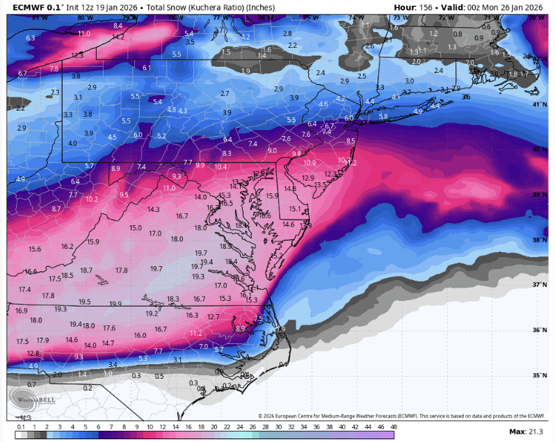
-

12th Annual Mid-Atlantic Snowfall Contest
North Balti Zen replied to RodneyS's topic in Mid Atlantic
The go big or go home bottom of the ledger casting their eyes at this next few weeks and crossing fingers... -
I'm getting literal chills from this pattern. Feb 2010 vibes.
-
That is a legitimate blizzard every day ending in 'y'.
-

January 24-25: Miracle or Mirage
SomeguyfromTakomaPark replied to stormtracker's topic in Mid Atlantic
AI Ensembles did tighten up the northern edge a bit, perhaps it lost some of the more northerly solutions. But it did increase total qpf in dc. -
It’s been posted already
-
Some would say there’s a decent signal at this range.
-
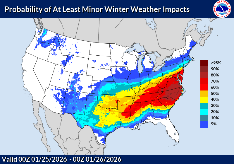
Gotta be soon considering almost every model except the GFS shows a big snowstorm for most of us!
-
Shame it's forecasted to be cloudy and dangerously cold since there's a great northern lights opportunity tonight.
-
Just for clicks .
-

January 25/26 Jimbo Back Surgery Storm
WarmNoseHater replied to Jimbo!'s topic in Southeastern States
can you post it a snapshot? -
All obs this year for me are from Fallston, MD - 11/30 - T 12/2 - A little frz rain to start - trees and car glazed - but 35 and rain for most of event 12/5 - T (dusting from a few hours of flurries as dry cold death air ate any chance of anything else north of BWI 12/14 - 4” 1/2 - .2" (frontal passage snow squall dealie 1/17 - .7" 1/18 - .5" Running season total - 5.4”


