All Activity
- Past hour
-
Mixed precip just started here. Should transition to all snow pretty quickly.
-

Ice Ice Baby December 28-29 Storm Discussion
Typhoon Tip replied to Baroclinic Zone's topic in New England
I'm telling you the synoptic limitations that are in the actual models. The interpretation after the fact, now sure where this 'I gotta bad feeling ...' trope is necessitated from. Using your worlds, we can't even support the doom interpretation: 'even if 50%' ...well, 50% of what. .9 accretion? that's arithmetically only .45, less than standard warning ice. Ice "storms" don't typically manifest the way this is modeled for a reason. I explained that list of constraints the way I see them - but you didn't read them or don't understand? Because if you did, you wouldn't have asked. It's like the people in here block the rationales that constrain interpretation. I dunno. Seems like it. The event timing is too fast. Falls rates may be moderate, and accretion efficient for a time, but it's moving off way, waaay faster than climo icestorm typology. Yeah, 2007 ... but that was a unique situation, and it was also longer than this will be, too. As icing sets up, it release latent heat of phase change; there need be a constant lower DP source to offset this physical process of fixing. There is no source for that. -
No explanation, but I have to mention that someone posted JB saying he thought a trough would retrograde from the east. Maybe he was on to something.
-

Ice Ice Baby December 28-29 Storm Discussion
ORH_wxman replied to Baroclinic Zone's topic in New England
Anytime I see 925-950ish going above 0C relatively quickly, I sell big ice accretion. You’d need something super inverted like 20F at the sfc to overcome the warm drops. -
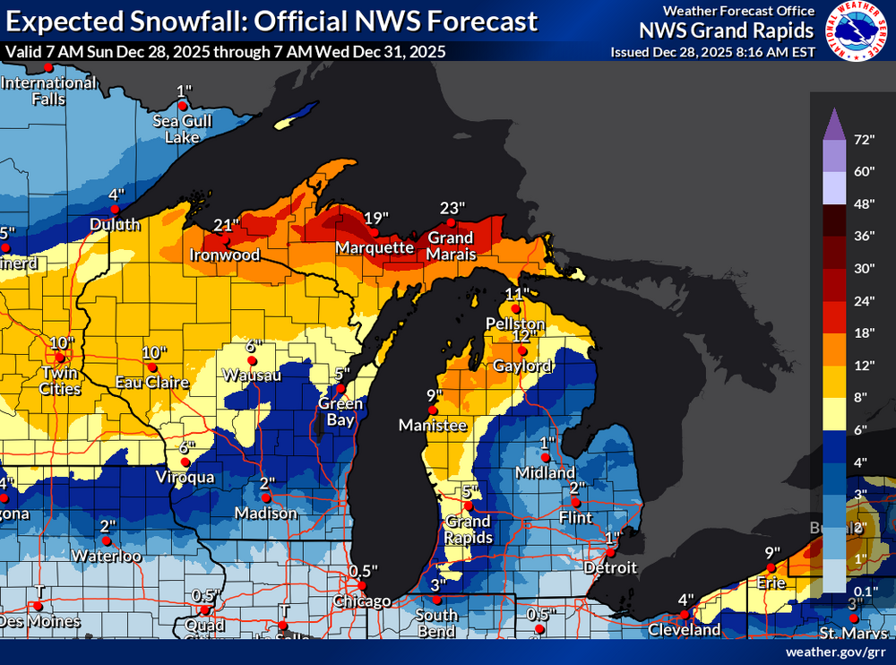
On the southern fringe for this one. Added to my existing tree ice overnight. Still below freezing but expecting a roughly 12 hr window reaching into the upper 30's. If the ground glacier can hold on the 3" of wind-blown snow tomorrow could at least make for some potential drifting. Storm Warning just a half county NW of here. Overall amounts have trended up on the regional NWS forecast map (a little bit may be from weaking clipper Tue/Wed fwiw)
-

Ice Ice Baby December 28-29 Storm Discussion
dendrite replied to Baroclinic Zone's topic in New England
But it only takes 15 minutes of freezing drizzle to turn I93 into a demolition derby. At least the state piled a couple hundred thousand pounds of salt on the highway for the 1” the other day so the salt residue remains. -

Central PA Winter 25/26 Discussion and Obs
Superstorm replied to MAG5035's topic in Upstate New York/Pennsylvania
Man that looks good. Just need that primary to be just a little less aggressive. . -
Ice Ice Baby December 28-29 Storm Discussion
dendrite replied to Baroclinic Zone's topic in New England
And to Tip’s point…. A short period of +RA with marginal <32° temps and no evaporative cooling offset isn’t going to result in significant accretion. A lot of that liquid will run off and “waste” to the ground. -

Ice Ice Baby December 28-29 Storm Discussion
Damage In Tolland replied to Baroclinic Zone's topic in New England
Yeah -
Ice Ice Baby December 28-29 Storm Discussion
ORH_wxman replied to Baroclinic Zone's topic in New England
I hated that storm but always love your account of it. We almost got our pack wiped in that one. Only reason we didn’t was because there was so much sleet and water equivalent in it from like 5 previous high QPF events that had started with the Dec 29-30, 1993 storm. But it was mowed down to about 2” of glacier. -

Ice Ice Baby December 28-29 Storm Discussion
jbenedet replied to Baroclinic Zone's topic in New England
Freezing is a warming process. Temps will spike quickly to 32 everywhere except the valleys of NNE. -
Ice Ice Baby December 28-29 Storm Discussion
dendrite replied to Baroclinic Zone's topic in New England
Gotta separate QPF as ZR and actual accretion too. I think you’ll have some decent icing up there around 1k Gene. But there’s really no ageostrophic lower dewpoint drain to offset the diabatic warming so once the ZR begins it’s a slow trend upward to 32°. I think we’ll probably wedge into the 30s until the cold fropa, but I think any additional accretion ends here in the morning and maybe mid to late morning up there. -
*Meet up* I'll be at Kasoag Lake tavern and grill on Friday January 5th at the base of the Tug Hill. I'm going to rent a snowmobile and head up onto the Tug Hill. The forecast from Jay, at Kasoag Lake is for an intense lake effect snow band that will drop feet of snow on the region.
-

Boxing Night Snow/Sleet/Ice Dec 26-27 Storm Thread/Obs.
Ralph Wiggum replied to Mikeymac5306's topic in Philadelphia Region
Fun times! And no security cams recording the lot and snapping license plate photos. -
0z EPS for the 4th- vorticity and surface pressure- got some southern stream action. Precip stays south just to the south.
-

Ice Ice Baby December 28-29 Storm Discussion
wxeyeNH replied to Baroclinic Zone's topic in New England
I just saw this right after I made my post. Would all these negative factors apply for us up here too? -
Wishing a road trip was in the cards tbh.
-
Ice Ice Baby December 28-29 Storm Discussion
jbenedet replied to Baroclinic Zone's topic in New England
Zzzzzzz -
Ice Ice Baby December 28-29 Storm Discussion
wxeyeNH replied to Baroclinic Zone's topic in New England
Tip, yesterday, Dandy was also not very impressed for even up here. What am I missing? 1.25" of liquid, temperatures in the mid to upper 20s rising to around 32F tomorrow afternoon. Longer precipitation time up here too. Weather bell clown ice maps show .75 to 1.00" of ice. Even if that is 50% overdone, this seems like a big deal up here????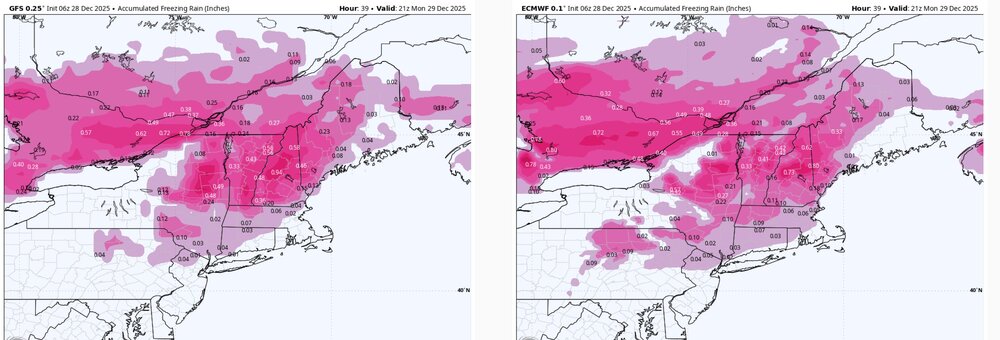
-

Central PA Winter 25/26 Discussion and Obs
pawatch replied to MAG5035's topic in Upstate New York/Pennsylvania
CPT non-diurnal temperature trend the next 36 hours I looked it up, one answer…These are what we call non-diurnal temperatures. It's a fancy way of talking about high or low temperatures that don't occur when they usually do. 28 degrees this morning. -
Ice Ice Baby December 28-29 Storm Discussion
Typhoon Tip replied to Baroclinic Zone's topic in New England
No need to... the cold you are referring is particularly low level, and substantive in the mass loading into this system's preceding environment. The "real" synoptic cold is still low ... 22-ish with DPs of 10 or so, but with such limited +PP ( positive pressure pattern (high pressure) ) situated N, a 20 to 25 kt sustained 925 mb low arriving flow will change the setting very quickly. These metrical limitations on this system are not going anywhere. They are a predicament/detriment to this system's ability to maintain froze or freezing profiles. Lemme tell you something ... in late January 1994, we awoke one faithful morning to Winter Weather Advisory headlines in place, a temperature of 9 F on the weather lab's tele, and periodic flurries/grits coming down in the blue light of dawn throughout the Merrimack Valley. Deep winter was in place. By noon, sleet pellets had broken out, there was a south breeze, and the temperature had risen to 23 or so... By 3 pm, it was 31 F with steady freezing rain. By 6pm, it was 53 F with wildly swaying tree tops, and ice fog rolling off the snow pack and piles. By 9pm, it was 61 F with 55 mph gusts. Student around the campus had spilled into the commons and down town in Lowell, in short sleeve shirts to finalize the defiance in mockery of winter... 9 to 61, in 12 hours. All because a cutter went through BUF-ish, and had no antecedent +PP to protect from the arriving WCB ( warm conveyor belt ) -related wind field. Now, this situation doesn't have a 65 kt 920 mb jet core fire hosing at it...no. But, the 40 kts with no leading surface high is going to still reverse the tables and do it probably at a speed that comes to some surprise to people, even in the valleys. -
Ice Ice Baby December 28-29 Storm Discussion
dendrite replied to Baroclinic Zone's topic in New England
Maybe one of those setups where you shoot up to 40° while Ryan is still -ZR in WeHa? -
Nice overperforming storm. Forecast that morning was 1 to 3. Then upgraded to 3 to 6 in the afternoon and ended up with close to 8.
-
MSLP anomalies show a low passing to our south around the 4th and then a storm developing along the coast on the 6th/7th, then another around the 9th. Lots of spread obviously, but I think the H5 look is mostly due to the troughs developing when they hit the water.
-
Ice Ice Baby December 28-29 Storm Discussion
Damage In Tolland replied to Baroclinic Zone's topic in New England
Models always warm too quickly in these setups. If it can stay below 40 until noon, might be ok .


