All Activity
- Past hour
-

December 2025 regional war/obs/disco thread
Typhoon Tip replied to Torch Tiger's topic in New England
LOL, the CFS from 00z is the best model of all for the 14th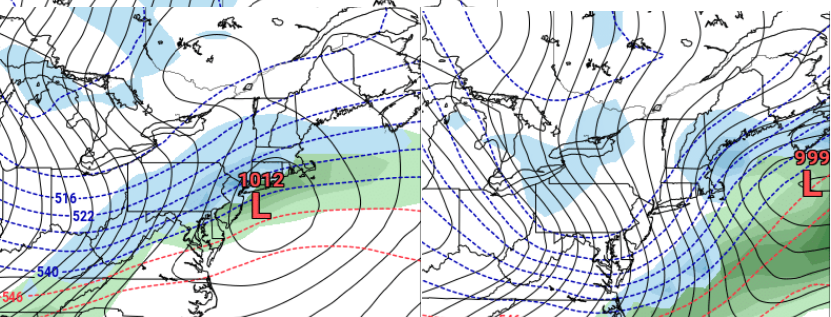
-

Central PA Winter 25/26 Discussion and Obs
WmsptWx replied to MAG5035's topic in Upstate New York/Pennsylvania
I drove up to Philipsburg this morning from Three Springs and it was a consistent 25°F on the ride up and temps got to about 29°F currently. Cold rain coming today. Beautiful. -
Merry Warm up. Need to go back in time to get even a normal winter. I miss you Nor'easters and SECS/ MECS .
-
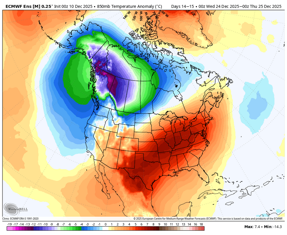
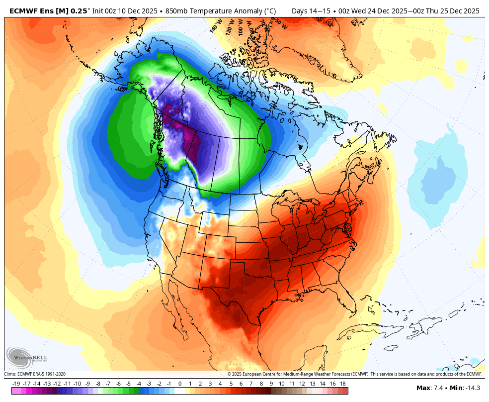
As I said in the MA forum yesterday, it won’t take much to shift that wpac warm pool slightly east to favor MJO 7-8 instead of 4-6. MJO 7 has sometimes shown to be a precursor to our biggest storms. And while the warm up is getting more aggressive on the models, my overall thoughts have not changed about 1) Neg WPO, 2) cold air source in Canada, 2) MJO waves into 7 and 8, and 4) increased chance of blocking due to stratosphere activity. These will increase the likelihood of a cold January moreso than a warm one.
-

December 2025 regional war/obs/disco thread
weatherwiz replied to Torch Tiger's topic in New England
along with scattered rain showers -
It's a bit deceptive outside now at least imby in southwest Garrett County. Temp is 44 with the sun shining - hardly what you would expect for a blizzard warning (begins in 45 minutes). In fact, the last blizzard warning I had last winter, the day ended up being sunny for 90% of it with next to no snow and very moderate winds. But today, I've had multiple gusts exceed 50 MPH and if/when the snow begins, it'll be tough going. So...bring it!
-
It’ll verify here as variably cloudy and 38°
-
Squall potential faded away about a day ago, and the associated winds as well. Very poor handling in the short term by guidance.
-

Winter 2025-26 Short Range Discussion
sbnwx85 replied to SchaumburgStormer's topic in Lakes/Ohio Valley
Kind of shocking to see clippers take the exact same track back to back. -
Did I ever mention how much this hobby sucks?

-
for now I'm going with the least snowy model until something changes... that's the trend. I've been let down far too long to be excited for Sunday!
-
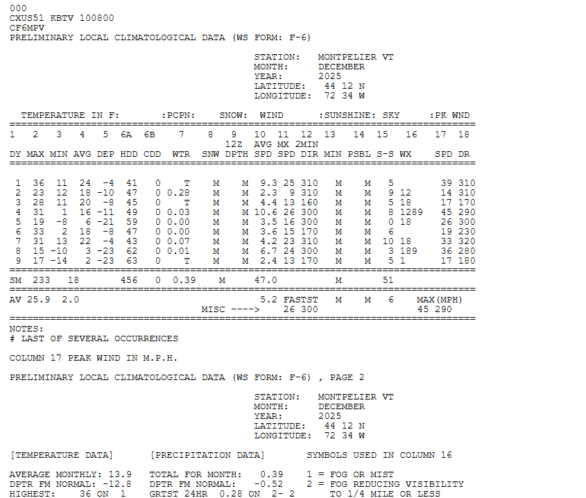
Thanks. Our areas had a freezing fog advisory late last night, which I believe is quite rare:309 AM EST WED DEC 10 2025 ..PATCHY FREEZING FOG THIS MORNING AREA OBSERVATIONS, SATELLITE IMAGERY, AND WEB CAMS INDICATE THAT PATCHY DENSE FOG IS IMPACTING PORTIONS OF SOUTHEAST GEORGIA AND SOUTHEAST SOUTH CAROLINA EARLY THIS MORNING. MOST OF THE PATCHY FOG IS SHALLOW, BUT IS PRODUCING VISIBILITIES OF A QUARTER OF A MILE OR LESS IN ISOLATED AREAS. MUCH OF THE FOG IS FORMING AS STEAM FOG NEAR WATERWAYS INCLUDING RIVERS, STREAMS, TIDAL CREEKS, AND MARSHES. TEMPERATURES ACROSS THE AREA HAVE FALLEN BELOW FREEZING AND INTO THE UPPER 20S IN MANY LOCATIONS. FREEZING FOG WILL OCCUR, EVEN PRODUCING LIGHT RIME ICE ON ELEVATED AND EXPOSED SURFACES. WHILE LOW VISIBILITIES COULD IMPACT TRAVEL, ESPECIALLY WHERE VISIBILITIES CHANGE SIGNIFICANTLY OVER SHORT DISTANCES, RIME ICE FROM FREEZING FOG IS NOT EXPECTED TO PRODUCE ANY IMPACT ON TRAVEL CONDITIONS. TEMPERATURES WILL RISE ABOVE FREEZING, AND ANY LINGERING FOG WILL DISSIPATE, BETWEEN 8 AND 9 AM THIS MORNING. PRECAUTIONARY/PREPAREDNESS ACTIONS... IF DRIVING, SLOW DOWN AND LEAVE EXTRA DISTANCE AHEAD OF YOU IN CASE A SUDDEN STOP IS NEEDED.
-
December 2025 regional war/obs/disco thread
weatherwiz replied to Torch Tiger's topic in New England
Might see a Christmas Day severe weather outbreak in the Mississippi/Ohio Valley if this keeps up -

Winter 2025-26 Short Range Discussion
A-L-E-K replied to SchaumburgStormer's topic in Lakes/Ohio Valley
next couple trending the wrong way for chicagoland and appearing p locked in -

December 2025 regional war/obs/disco thread
metagraphica replied to Torch Tiger's topic in New England
Let's DEW it! -
December 2025 regional war/obs/disco thread
weatherwiz replied to Torch Tiger's topic in New England
Yup...definitely something to consider. Could see 564 heights at 500 and +10C at 850 but could easily be wedged at the sfc -
December 2025 regional war/obs/disco thread
weatherwiz replied to Torch Tiger's topic in New England
I'm ready for May. Time to fire up the thread -
December 2025 regional war/obs/disco thread
Typhoon Tip replied to Torch Tiger's topic in New England
If this suddenly arrives in the grids and has more physical forcing then those on-panels (above) might get 10 or 20% more meaningful to the region ( S-E). If less, the flatter versions there prevail. -

-
Ripping nicely with this band swinging through
-
Normally I'd take the EPS but its been junk lately. I'll blend the two.
-
Read my post. Pretty sure it explains the confusion/contention
-

Central PA Winter 25/26 Discussion and Obs
Itstrainingtime replied to MAG5035's topic in Upstate New York/Pennsylvania
I left for work at 8:30 (don't judge, I have a late meeting today) and it was 34 with a few sprinkles falling at the house. My low yesterday morning was 12. -
The first 10 days of December have been pretty chilly.
-
December 2025 regional war/obs/disco thread
Typhoon Tip replied to Torch Tiger's topic in New England
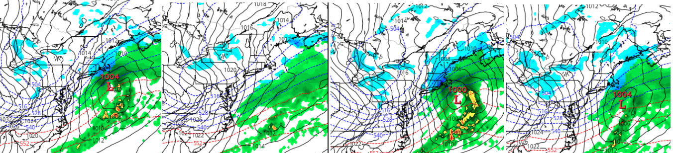
right. you know, tracking that s/w's spacing back in the flow ..it's not even yet over the American owned sounding domain. I'm sure we're not exactly purchasing sounding data from Russia heh ...if they are even plumbing the skies over Siberia at all in the first place. Anyway, it's all based on assimilation. Although satellite sounding. Still, it's almost like the models assume something should be there in the flow in that spatial-temporal/geometric region, then propagating the assumption along ...at difficult to manage, ludicrous speed. Perhaps if there was better physically realized, direct sampling the handling might be more stable. I mean I suspect something like this is going on. Look at the Euro's last 4 cycles ... left to right, the most recent to 24 hours ago ( 6 hours apart). On off on off... That's been rather predictable just within that small range. Something perhaps added than missing every other run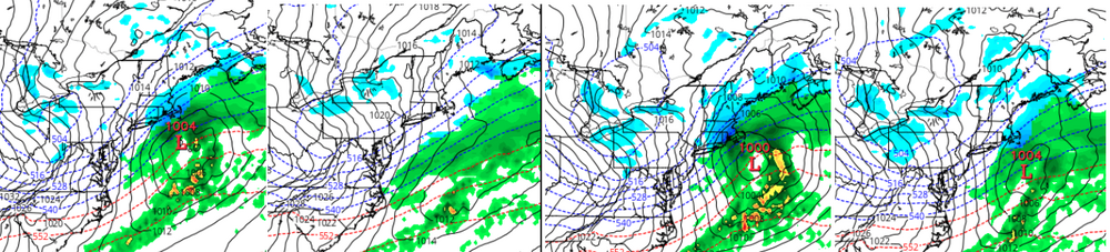


.thumb.JPG.418e8a9a2902ae687ec35ff4bc0e038e.JPG)