All Activity
- Past hour
-

"Don’t do it" 2026 Blizzard obs, updates and pictures.
Ginx snewx replied to Ginx snewx's topic in New England
We built a new insulated coop with a solar door leading to a hoop coop that is covered during the winter. So far so good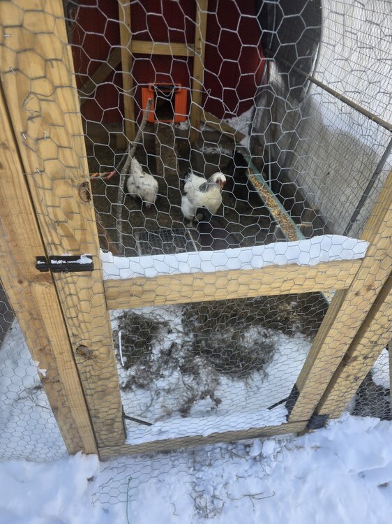
-

2026-2027 El Nino
Stormchaserchuck1 replied to Stormchaserchuck1's topic in Weather Forecasting and Discussion
Significant Stratosphere Warming event to occur in early March. Does a March SSW precede a later-in-the-year El Nino? No. -
Torch!
-
Today's split EWR: 48 /32 (+2) NYC: 49/ 38 (+7)
-
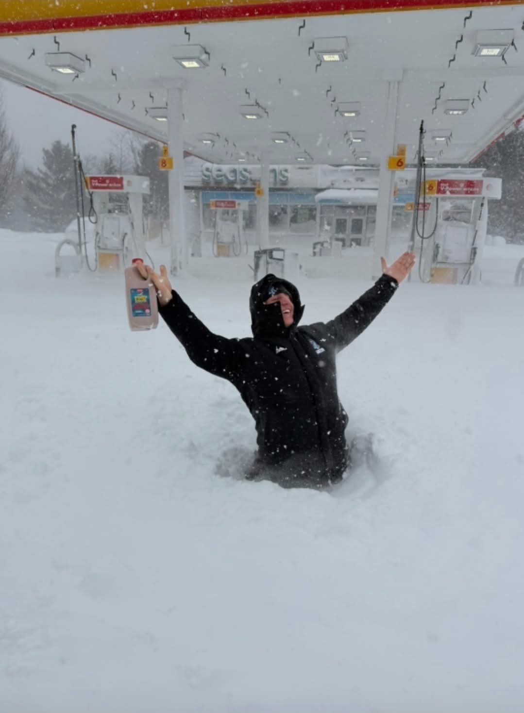
"Don’t do it" 2026 Blizzard obs, updates and pictures.
Ginx snewx replied to Ginx snewx's topic in New England
Ryan Hanrahan posted this of a guy from Narragansett if that isn't enough proof...
-
NAM backed off at 0z. Significantly
-
What did you get? I heard it ripped for 3 hours
-

"Don’t do it" 2026 Blizzard obs, updates and pictures.
vortex95 replied to Ginx snewx's topic in New England
Confirmation bias, one of the most common logical fallacies and *rife* in society, as has always been, but the age of information overload has exacerbated it. -

Outta gas and Outta Time: Early March Winter Storm finale
Ruin replied to Ji's topic in Mid Atlantic
dont buy what these models say -
"Don’t do it" 2026 Blizzard obs, updates and pictures.
vortex95 replied to Ginx snewx's topic in New England
Thanks for the info/input. The 2/2/1976 storm, yes 957 mb at CAR is their lowest pressured on record. BOS had 965 mb for its second lowest on record (has this been matched or exceeded since?). Bliz of 93 was about 963 mb when it passed over central MA (up from 960 mb peak over the Mid-Atlantic). What is the "OV Blizzard?" The Feb 1976 one? The Jan 2018 blizzard offshore SE of ACK was 950 mb. I seem to recall in the New England Wx Book (Ludlum) stated a storm SE of ACK in the mid 20th century was 947 mb. The "CLE Superbomb" Jan 1978 lowest was 956 mb in Mt Clemens MI. The New England non-tropical pressure record is 955 mb at BID set on 3/7/1932. And Canton NY had 955 mb in a Jan 1913 storm. These are the lowest non-tropical pressures for the CONUS, although very close is 955.2 mb at Bigfork MN set on 10/26/2010. The -
"Don’t do it" 2026 Blizzard obs, updates and pictures.
vortex95 replied to Ginx snewx's topic in New England
So did the high winds knock the ratios down as expected? Never had realized that until it was brought up leading up to this past storm. -
I’ve not been sold on this being more than melt and mud season. I don’t like the fact that the smeared out polar vortex is on this side of the north pole; it inherently means that we’re gonna have a compressed flow and fast flow in southern Canada. That’s a recipe for wedging… That’s always been there. It doesn’t mean we can’t get super warm but it just makes it really dicey wouldn’t feel comfortable going for that at this range.
-
"Don’t do it" 2026 Blizzard obs, updates and pictures.
vortex95 replied to Ginx snewx's topic in New England
You get *that* much "mashed potatoes," that's whats going to happen. Not often you get so much snow that is wet/high LEQ for the duration of the storm. Same thing happened in the DC area for the storm last month (plows getting stuck/equipment breaking), but for a different reason. 6" of snow, followed by 2-4" of PL, then a seal coast of FZRA! Then wicked cold after. It turned into a glacier quickly ("snowcrete" came up as a term, new one for me!) and made snow removal unusually difficult. This is why I say that I would take 3 ft of fluff over 6" of mashed potatoes any day, at least when it comes to overall impact and the hassle of driving in it and cleaning it up! -

Occasional Thoughts on Climate Change
TheClimateChanger replied to donsutherland1's topic in Climate Change
-

February 2026 OBS & Discussion
donsutherland1 replied to Stormlover74's topic in New York City Metro
It has been a snowy winter in the northern Mid-Atlantic and southern New England areas. Already, Islip, JFK Airport, and Providence have clinched top 10 seasonal snowfall figures.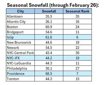
-

Winter 2025-26 Medium/Long Range Discussion
McHenrySnow replied to michsnowfreak's topic in Lakes/Ohio Valley
"Meteorological winter" isn't real. -

Central PA Winter 25/26 Discussion and Obs
boo radley replied to MAG5035's topic in Upstate New York/Pennsylvania
What a game by Sixers tonight -
Spring is showing up on the models,

-
Next weeks event is looking worse and worse. Maybe we could squeeze out 2-3” Sunday?
-

"Don’t do it" 2026 Blizzard obs, updates and pictures.
tunafish replied to Ginx snewx's topic in New England
I remember reading somewhere that was the biggest threat to their temp - moisture - amd I thought specifically feet. My oldest hen is 5, the buff, and at her old age she won't step on ice or snow, unless she absolutely has to, lol. My biggest concern this time of year is Hawks. The ermine I had slinking around their run a month or so back has moved on. Had it's fill of meadow voles, couldn't get into their run, and thankfully took off. -

Outta gas and Outta Time: Early March Winter Storm finale
Chris78 replied to Ji's topic in Mid Atlantic
I'd think we want the GFS to be more correct but further north. If we're waiting on precip till later on Tuesday I don't think the high will hang on. -
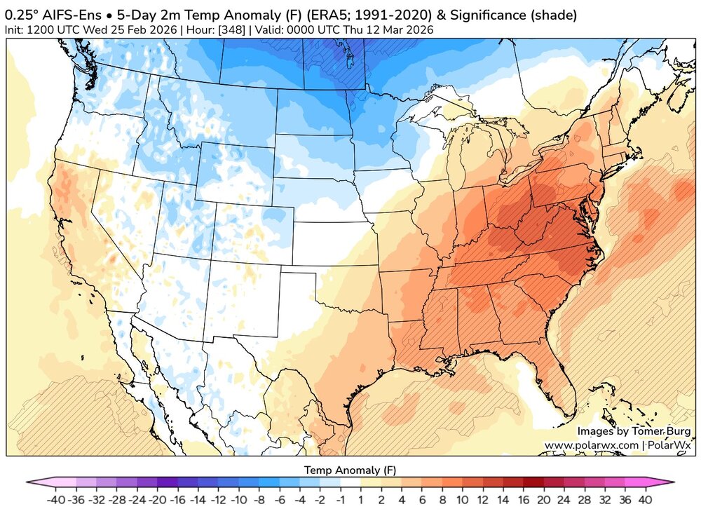
Cool graphic on Tomer’s page. Strong signal for a torch .. except for us, lack of the black shading indicates there is much more uncertainty for us warm sectoring - while Central Jersey is 75 we could be stuck in the 30s/40s.
-
"Don’t do it" 2026 Blizzard obs, updates and pictures.
Ginx snewx replied to Ginx snewx's topic in New England
Phew that's rough -

Outta gas and Outta Time: Early March Winter Storm finale
CAPE replied to Ji's topic in Mid Atlantic
Yeah I posted about this earlier. Still subject to change at this point. Whatever wave it is, it has to strike when that HP is in place to the north. Once it slides east off the coast its pretty much over for our area for a decent snow event. -
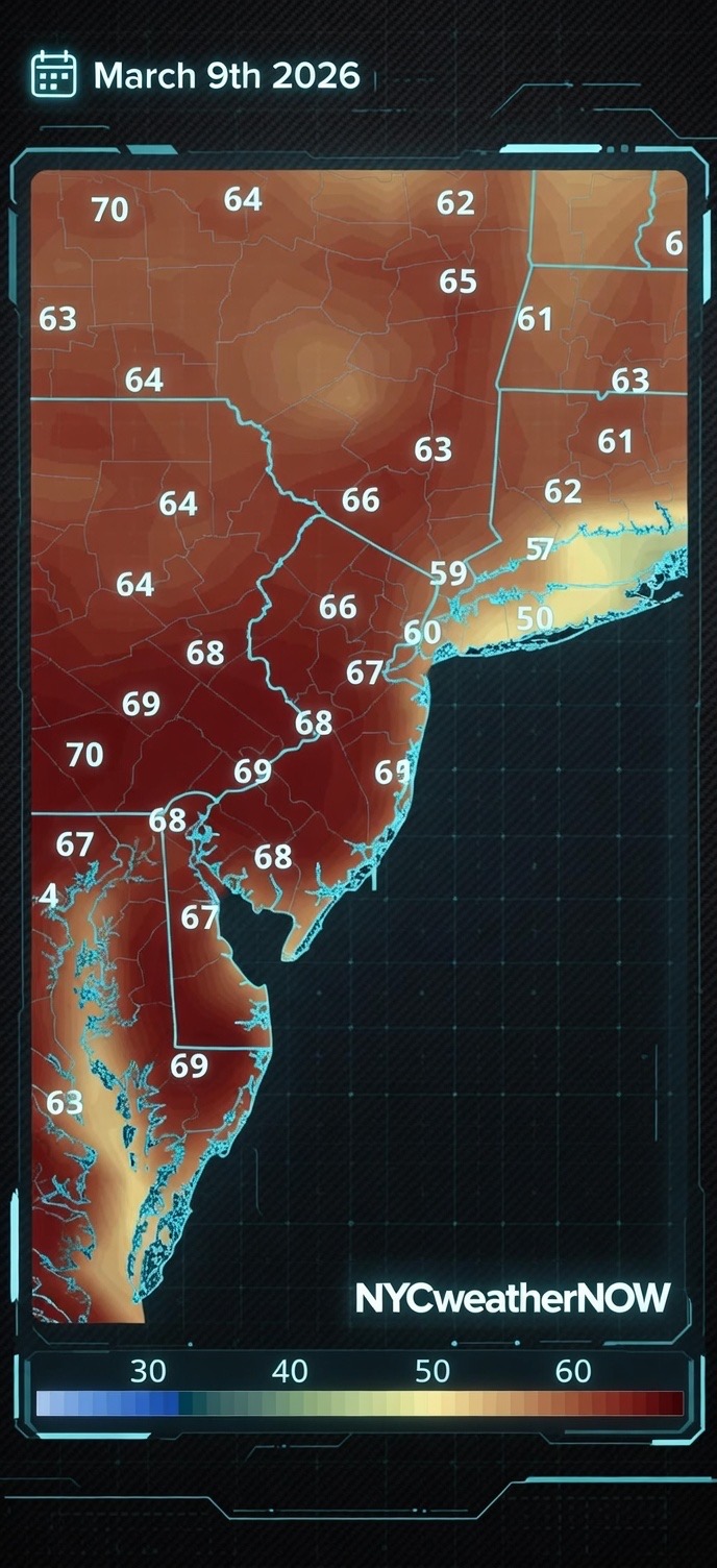
2025-2026 ENSO
donsutherland1 replied to 40/70 Benchmark's topic in Weather Forecasting and Discussion
The ECMWF weeklies suggest that spring begins for good during the week of March 9-16. The weeklies suggest the following teleconnection pattern during the second half of March: WPO-/ EPO+/ AO+/ PNA-. Using NYC as an example for the Northeast, the mean March 16-31, 1980-2025 temperature for such teleconnections is 46.6°. For all other cases, it is 45.3°. So, one isn't exactly looking at a cold pattern with those forecast teleconnections. Moreover, the ECMWF weeklies don't show a cold pattern. Fortunately, teleconnection forecasts are not skillful beyond two weeks. If one is looking for a genuinely colder pattern to develop, an AO- would offer perhaps the strongest possibility. Even leaving the other teleconnections as they are currently forecast (WPO-/EPO+/PNA-) but combining them with an AO- , the March 16-31, 1980-2025 mean temperature was 42.9°.