All Activity
- Past hour
-

December 2025 regional war/obs/disco thread
weathafella replied to Torch Tiger's topic in New England
Why do you have disdain for AI weather models? -
@40/70 Benchmark @bluewave @donsutherland1 La Nina peaking within the next 2 weeks or so?
-

December 2025 regional war/obs/disco thread
weatherwiz replied to Torch Tiger's topic in New England
Bingo. That's exactly what I could see happening. People in charge of making critical decisions will take AI at face value and that will set the stage for some disastrous decision making. And I'm not even talking in the sense of general public - this could be anything, logistics, supply chain, resource distribution, etc -

December 2025 regional war/obs/disco thread
Typhoon Tip replied to Torch Tiger's topic in New England
That's not the scary part. Not really. The scary part is that there are those that seem to be "gifted" in their utilization of the technology - just naturally so. Like they seem to gravitate toward usage. Just seemed 'get it' with a lucidity in engagement that makes them synergistic, ( potentially ) immensely powerful - with great power comes great responsibility. How irresponsible is that going to be? -
The gfs was god awful, contrary to “its got the best hold on this storm all week” nonsense posts.
-
Hal…is it going to be a nice day to hike Mt Washington today? ”Yes Dave. It looks warm and beautiful. Wear light clothing”
-

Central PA Winter 25/26 Discussion and Obs
CarlislePaWx replied to MAG5035's topic in Upstate New York/Pennsylvania
Here in Carlisle, my low overnight was 15.3 degrees. The wind almost never stopped blowing which prevented some from plummeting courtesy of deeper snowpack. I was already down to 17 at 6:00pm yesterday and hung out there for hours. Under a thin, milky overcast with dim sunshine my temp has risen to 21.6. Stay warm out there. I'll be staying nice and toasty indoors all day...lol. -
December 2025 regional war/obs/disco thread
weatherwiz replied to Torch Tiger's topic in New England
As much as I don't like AI, that doesn't mean I don't believe there is value in it, however, I don't think its value outweighs the "bad" and that's where I see the problem. In terms of weather, I think AI could have tremendous value in the nowcasting (<6-12) hour window, particularly when it comes to severe weather and flash flooding potential. In terms though of using AI as like medium/extended range (maybe even short range), I see little value - AI models in this range will not tell us what a great forecaster will not already know. The only way we will ever greatly improve forecasting skill in this range is to better understand how the atmosphere and how it evolves and better understanding physics and processes...then it's taken that and quantifying that numerically so computers can process this information. Computer forecast models struggle as you move away from initialization because of compounding error. This was why for a prolonged period of time the euro was by far and away the best, it had superior initialization skill - the euro would have very few error inside of 72 hours which resulted in greater accuracy through 5 to even 7 days. AI isn't going to solve medium-to-long range error or reduce inconsistencies...AI will not do this until we ourselves are better able to understand this and teach the algorithm to do this. -

December 2025 regional war/obs/disco thread
Great Snow 1717 replied to Torch Tiger's topic in New England
Because some people take them as "gospel" ???? -

December 2025 regional war/obs/disco thread
SouthCoastMA replied to Torch Tiger's topic in New England
I just wasn't sure how they would be dangerous? Unless AI was used to create fakess outputs/forecasts to fool people..which I suppose could be true. -

Central PA Winter 25/26 Discussion and Obs
pasnownut replied to MAG5035's topic in Upstate New York/Pennsylvania
yeah, my trek took 15 min extra and was rather slick, but It doesnt bother me.....just the person doing 20 in a 40 that is always in front of me....lol -

Central PA Winter 25/26 Discussion and Obs
Superstorm replied to MAG5035's topic in Upstate New York/Pennsylvania
Made it to 14 in Willow Street area la casa. As Itstraining time mentioned, lots of icy roads on the way to work. . -
Central Park got updated to 2.9”
-
It is total BS. All those dumb stats are meaningless when pretty much every single other location, N, S, E and W got above 3" Let the people circle jerk to their stats, that are obviously wrong, and the rest of us can live in reality.
-
December 2025 regional war/obs/disco thread
Great Snow 1717 replied to Torch Tiger's topic in New England
I am not sure why anyone would object to the question I asked... -
December 2025 regional war/obs/disco thread
Great Snow 1717 replied to Torch Tiger's topic in New England
I agree...just read the article about the former member of the Rice University Womens Soccer team. I am a long time chess player, AI has been a part of the chess world for many years. It is a valuable tool in the chess world...so there are situations where AI can have a positive impact but to your point I agree with you for the most part. -
Come on guys. Lets look at the EPS, It shows above average for over a week. Dec 20-29 all looks at or above average. Only thing that will save us is CAD or rain or both.
.thumb.png.04f0f8cf82a23b0db52e80dd9caf7f73.png)
-
Persistent trough in the goa/pacnw is a bit of a dagger here without real help from the AO. Cold fronts can sweep thru the east but storms will almost certainly track far NW of us. Hopefully it retros and the pna rises within 2 weeks or the blocking hammer drops down. Patience for now....
-
It was 12 degrees this morning, with a fresh covering of 1.5” of snow in mid-December. Deep winter at its best
-
Upper 60s on Christmas eve and pushing 70 on Christmas Day is pretty torchy to me. Why are we even looking at the GFS or GEFS its awful.
.thumb.png.fce97ddb3971b5b28df99e85d7a3851b.png)
.thumb.png.647d4e021b9ffbfdc756e620904e2dc9.png)
-
December 2025 regional war/obs/disco thread
weatherwiz replied to Torch Tiger's topic in New England
His question was valid given my open disdain about AI weather models lol -
December 2025 regional war/obs/disco thread
weatherwiz replied to Torch Tiger's topic in New England
Those float around Facebook too...and there's this huge circulation too of videos of like destructive weather or chain reaction accidents. I guess at least there is wording that says, "This is AI generated and only for your entertainment" but it's stupid and dangerous. -
December 2025 regional war/obs/disco thread
Great Snow 1717 replied to Torch Tiger's topic in New England
I am asking for a clarification -

2025-2026 ENSO
donsutherland1 replied to 40/70 Benchmark's topic in Weather Forecasting and Discussion
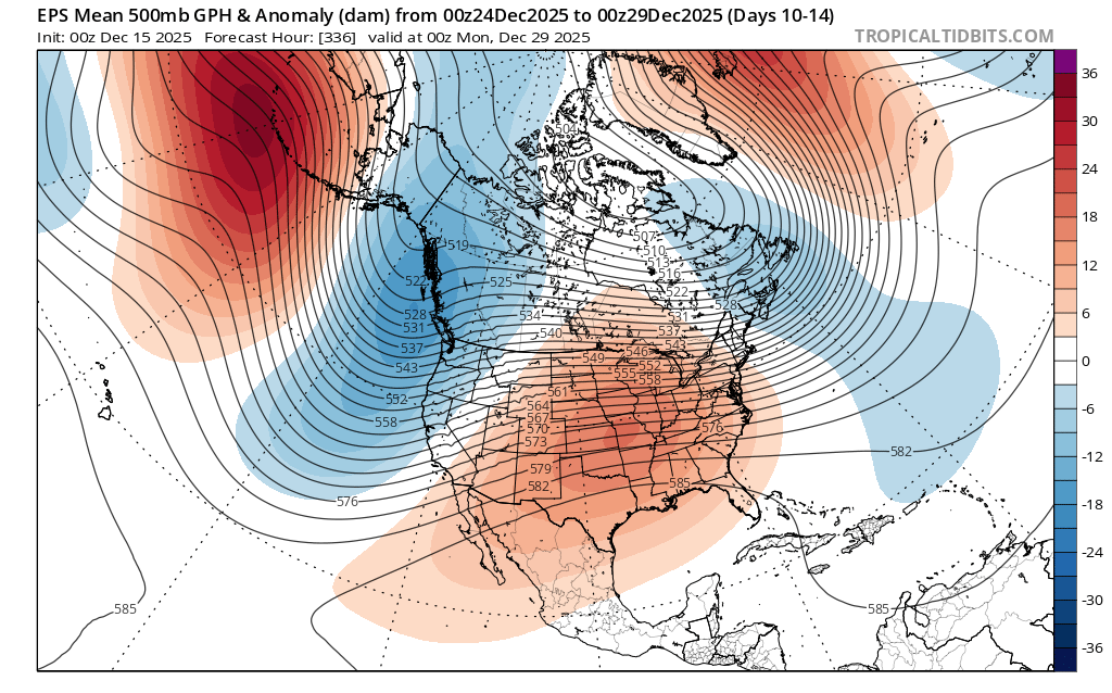
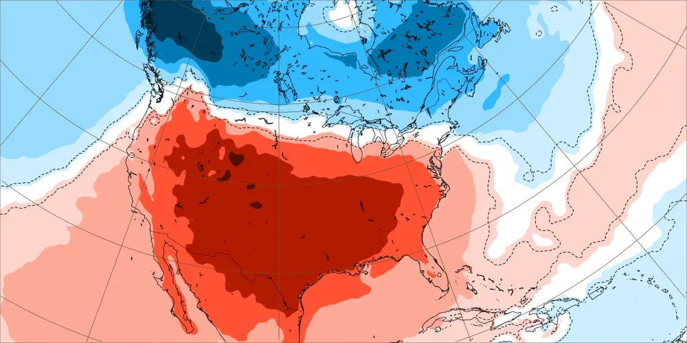
New York City saw its coldest first two weeks of December since 2005. The cold was even more impressive elsewhere: Charlottesville, VA (3rd coldest); Jackson, KY (3rd coldest); Marquette (2nd coldest); Paducah (4th coldest); and, Scranton (5th coldest). There was also impressive warmth in other parts of the northwestern U.S. Boise (4th warmest); Burns, OR (2nd warmest); Missoula (3rd warmest); Pocatello (3rd warmest); and, Yakima (1st warmest). The most persistent teleconnections were the WPO- (which tanked) and the PNA-. Going forward, the WPO- is likely to become less negative, cutting off the unrelenting flow of cold air into western Canada and then the northern U.S. The EPO could go negative, which would blunt the full effects of warming across the northern tier of the U.S. and especially Canada. The PNA will remain persistently negative. The changes favor a Southeast ridge, strong trough in the Pacific Northwest, and a weakening trough over the Northeast and eastern Canada. Thus, the southern tier of the U.S. and perhaps most of the CONUS could see a warmer than normal December 20-31 period overall. The warmup could take time to develop in New England and the upper Midwest. Canada should remain broadly colder than normal for the period overall. The latest Day 10-14 forecast on the EPS illustrates a 500 mb pattern that is broadly what one would expect from the forecast teleconnections during that period. The GEFS is in good agreement with the EPS for that timeframe. Here's the December 22-29 weekly ECMWF forecast: Notice how New England and parts of the northernmost U.S. has near normal or even below normal temperatures. Canada is cold from coast-to-coast. Finally, the GEFS is showing a scenario similar to December 28-31, 2021 where warm anomalies develop in much of eastern Canada. Whether this is something that will occur toward the close of December or a bit later in January remains to be seen. The EPS and ECMWF weeklies keep eastern Canada cooler than normal albeit less cool than shown above through the remainder of December. For now, the EPS is the baseline scenario for the closing days of December. That would allow for some intrusions of cooler air into the Northeast.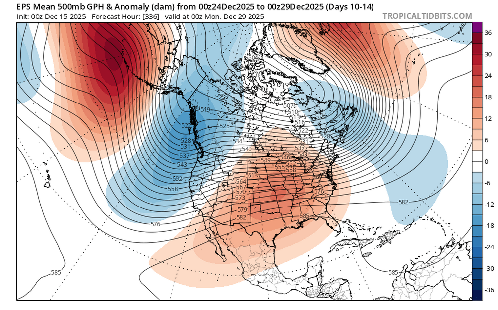
-
LOVE IT!!!!!!! Downtown for NYE in shorts!


.png.0c3100d3700166bd1acefd8704e89d32.png)


.png.03f1da18e7ff9126633d8d74d79dabde.png)
.png.5a469016dfb971fac6a6842995a22694.png)