All Activity
- Past hour
-

Central PA Fall Discussions and Obs
WmsptWx replied to ChescoWx's topic in Upstate New York/Pennsylvania
Interesting, I just saw somebody post this on social media.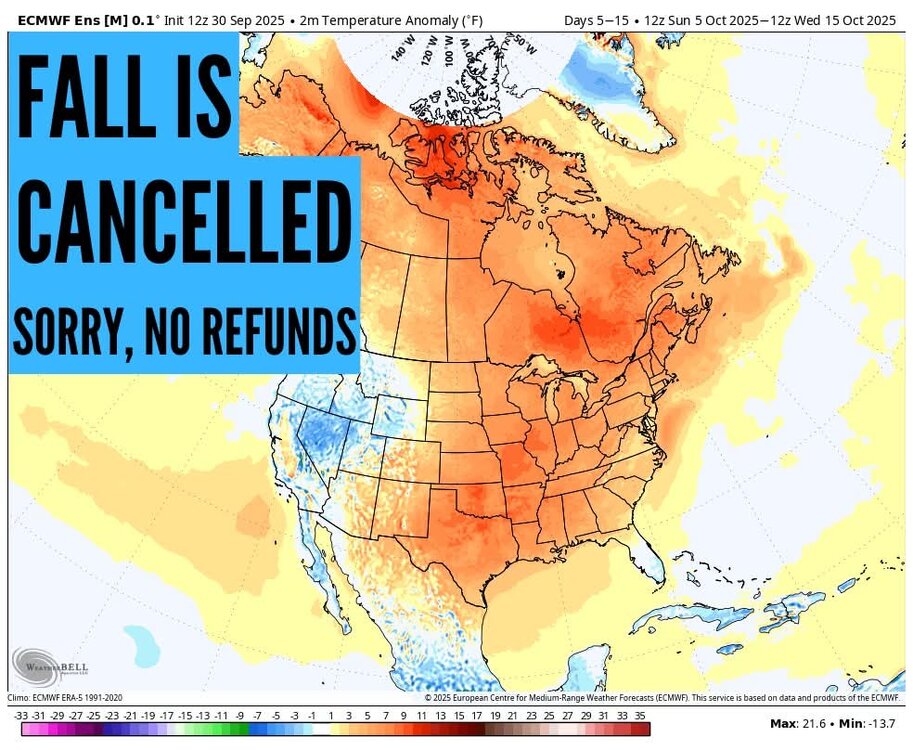
-
Unless you are involved in agriculture or gardening. Above normal temperatures during the warm season just dry things out when the rainfall is below average. Had very dry vegetation up here through the summer. But the water table has been high enough coming off the very wet pattern before last September so the reservoir levels are good for most locations.
-

September 2025 OBS-Discussion centered NYC subforum
LibertyBell replied to wdrag's topic in New York City Metro
what about for HECS Don (this I would define as a day with 10" or more of snowfall.) -
it's good to be cycling back from the excessive rainfall of recent years
-

September 2025 OBS-Discussion centered NYC subforum
donsutherland1 replied to wdrag's topic in New York City Metro
It depends on the timeframe one is using and how one defines snowiest week. Select data for Central Park: Snowiest Week (Based on Mean Daily Snowfall): 1869-2024: February 7-13: 0.4" per day 1991-2020: January 21-27: 0.6" per day Snowiest Week (Based on the Percentage of Days with Measurable Snowfall): 1869-2024: January 27-February 2: 16.1% 1991-2020: January 25-31: 15.7% Snowiest Week (Based on the Percentage of Days with 1" or More Snowfall): 1869-2024: February 1-7: 9.0% 1991-2020: January 21-27: 10.5% -
Longest streak in a decade up here without a daily inch of rain. Number of Consecutive Days Precipitation < 1.00 for NEW HAVEN TWEED AP, CT Click column heading to sort ascending, click again to sort descending. 1 244 2014-12-10 through 2015-08-10 2 240 1964-12-05 through 1965-08-01 3 200 2001-10-10 through 2002-04-27 4 194 1965-08-03 through 1966-02-12 5 171 2013-06-09 through 2013-11-26 6 160 1971-02-09 through 1971-07-18 7 159 1960-11-02 through 1961-04-09 8 151 2015-08-12 through 2016-01-09 9 148 2025-05-06 through 2025-09-30 - 148 1962-04-02 through 1962-08-27
-
* Ahem* don't mind the record rainfall that Albany and southern NY received the day after this data in this map was valid
-
It has been a struggle to get open in October in the 2020's but maybe this is the year. Maybe some cooler temps late in the month and Halloween on a Friday might create a marketing first day opportunity for SR and K.
-
You know the ground is dry when you go to water what's still surviving in your veggie garden and the water instantly repels off of the dirt.
-
Cat 2, 966 mb at 11 am
-
58/46. How Fall should be.
-
 Just got off night shift... so a bit late as well DCA: +1.8 NYC: +1.4 BOS: +1.3 ORD: +2.5 ATL: +1.7 IAH: +1.8 DEN: +1.3 PHX: +1.9 SEA: +0.3
 -
Grew up and remain a Reds fan. Adopted the Orioles as my second team when I moved here in 2009. I literally laughed out loud when this note hit my timeline this AM - Yep. That tracks.
-
Humbelda? But Humberto is likely already extratropical-it’s clearly a frontal cyclone now.
- Today
-
Extension of summer here for sure. It has been 90 or warmer a grand total of 3 times in October in Minneapolis. We could add 2 this year. The all time warmest overnight low for the month could be in jeopardy too. I still think we see a dusting of snow by Halloween.
-
Pressure dropped 3 mbs between passes, now down to 967
-
Very refreshing breeze today between the closest hurricanes on record in the satellite era and the big high to the north. Nice to get a few days closer to seasonable before the pattern warms back up again. Continuation of the dry pattern since September 2024.

-

September 2025 OBS-Discussion centered NYC subforum
Stormlover74 replied to wdrag's topic in New York City Metro
That or 3rd week of Jan -
From your lips to hopefully God's ears @George BM
-
https://x.com/andyhazelton/status/1973385028051636664?s=46&t=NyKvXvI1o-sJQb-68mmo4g
-
The southern side is much stronger right now and would be in line with the forward motion but models keep building a strong sting jet over the NW quad at some point near or over the island partly due to interaction with Humberto. Not a totally tropical evolution but one to watch to boost winds at a bad time for Bermuda. Imelda is trying to look pretty at the moment. Don’t think it holds this classic eye look for long though but it is definitely strengthening right now
-
I'm trying to live the lie that we still have real winters in this part of the world. Let me believe the hype for just a little bit longer.
-

September 2025 OBS-Discussion centered NYC subforum
anthonymm replied to wdrag's topic in New York City Metro
What do you think climatologically the snowiest week is? Second week of Feb would be my gut feeling. -
Seems like over them or just south of them is most likely at this point. Will be interesting to watch and see how this unfolds.
-
3.87" for the month (3.53" avg) 65.1 (66.8 avg) 50.6 +1 for 7am (48.8 avg) here in TH. A roller coaster month of very cool, and warm conditions. Was fortunate to get some decent rains, unlike others here in the sub.


.thumb.jpeg.406ecda2eec9e267302c22b9f128fe3c.jpeg)


