All Activity
- Past hour
-

Central PA Summer 2026 Discussion/Obs Thread
TheDreamTraveler replied to Voyager's topic in Upstate New York/Pennsylvania
The days leading up to the 4th look like they're going to be very hot -
do you drive the forklift faster through the warehouse to catch a better breeze?
-
Only thing we know about July 4th 9 days out is that it will be very warm to hot around here. Impossible to know how hot or anything about rain and storms at this point.
-
Then there's me wanting to take a mini vacation

-
I believe an all-time of 104 is in jeopardy in Greensboro either JULY 3rd or the 4th, we shall see- I believe the highest temperature ever recorded in Raleigh, North Carolina was 106 °F which occurred just two years on July 5, 2024.
-
some meaning, each and every one of us
-

2026-2027 Super El Nino
BlizzardWx replied to Stormchaserchuck1's topic in Weather Forecasting and Discussion
I think it IS pretty good right now for the most part. But I also think as the globe warms it will rise. It's really a function of lapse rates and a 30C surface is usually good enough to guarantee conditional instability for the time. But this ties back to my other post that a robust +IOD and +ENSO circulation could still cap it. -
I believe the highest temperature ever recorded in Raleigh, North Carolina was 106 °F which occurred just two years on July 5, 2024.
-
Would be really nice to be able to lock in a heavy precip event, but there is just too much uncertainty with position of the front, timing of waves, and overall strength of the system. My dream heavy rain scenario is convection along (or just behind) the front later Friday, overrunning showers and storms Friday night, and more elevated convection Saturday with the front hanging around and a shortwave.
-
mm... it was like this in it's 00z run, too. Maybe not quite as extreme, but it's an east outlier with the 500 mb total placement of key construct when comparing pretty much everything else. "Some" would probably be wise to bear that in mind ... that, and that fact that this model - as far as we can tell - is actually an ICON of shitty forecasting technology
-
Gorgeous afternoon so far. Sitting outside with dog, slight breeze watching planes on approach to Newark Airport. Really don't want to go to work
-
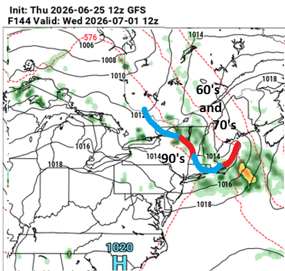
mmm one gets the distinct impression that model's attempting to limit or abolish heavy rain in the foreground, then, limiting any heat E of the Hudson ... leaving only the iffy hit or miss convection signal - which will be cleverly biased on the latter side of that chance.
-
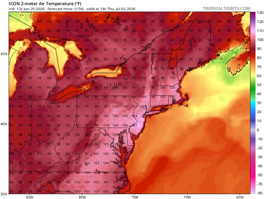
For heat enthusiasts ...this is your problem for next week
-
speaking of GFS...lets hope it verifies next week. We ride the MCS train
-

Pittsburgh PA Summer 2026 Thread
RitualOfTheTrout replied to TheClimateChanger's topic in Upstate New York/Pennsylvania
Hopefully we have a decent weekend for the 4th, hot summer time temperatures would be acceptable. Certainly looks warm next week. Should be a good week to spend some time in the pool. -
ICON gone wild next week.. some will be happy lol
-
-
-
Right on cue, rainfall looks to be on the increase as we near the end of June and head into early to mid July. Higher dew points, tropical connections, cold fronts and El Nino. https://x.com/SCweather_wx/status/2070165098128142678 The rain signal picking up for portions of the Southeast as we move into July.
-
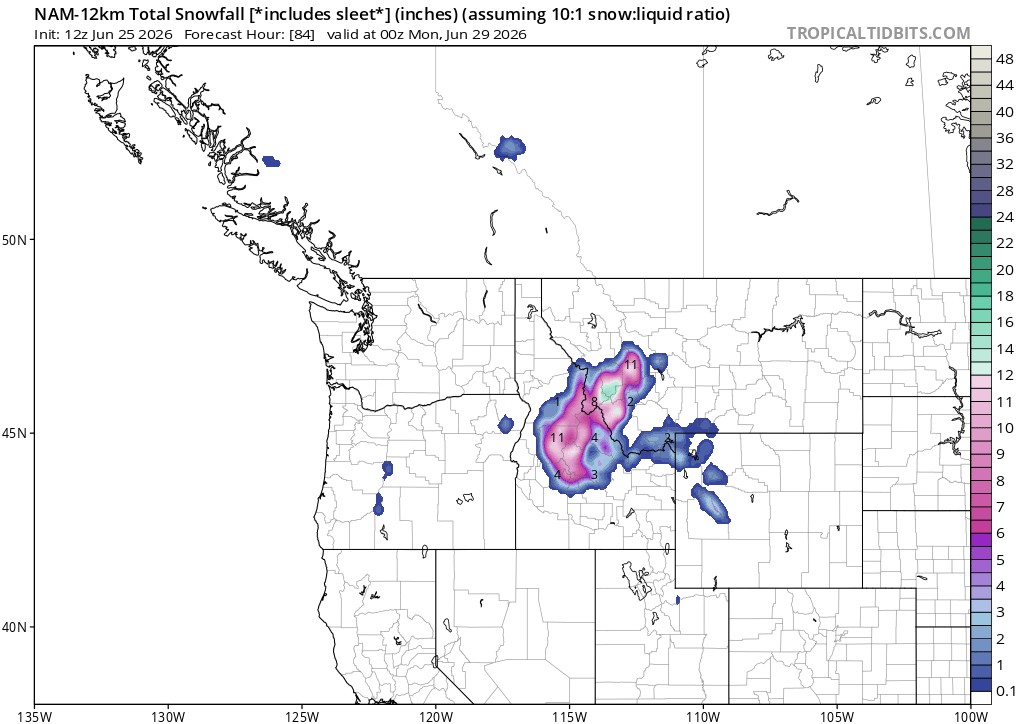
heh 12z GFS is no where near the NAM's idea. Having seen that...I gotta lean on the NAM being the NAM N-W bias at 60 hours. If this were circa November 20th and we were in the midst of a cool snap anyway whether there's anything on the charts or not ... Ineedelectroshock posters of the forum would be presently representing their razor sharp objective restraint by going hee-haw hee-haw galloot galloot galloot over this NAM's 6-10" warning snow event, having fully considered and judiciously constrained their emotions over the matter .... Maybe the Euro or some other model supports.
-
This weeks rainfall was helpful as generally 1-2.5” fell across the exceptional drought area though we would need to see repeated systems do the same to see any real progress. Sadly looks to be going back into the fryer this coming week with no signs of additional widespread rains
- Today
-

2026-2027 Super El Nino
LakePaste25 replied to Stormchaserchuck1's topic in Weather Forecasting and Discussion
That’s a good question. A warmer atmosphere can hold more water vapor (exponentially) but i’d think it also takes more to actually wring it out. The warmer SSTs certainly help with that. Intuitively i think the “magic number” would have to go up as it warms. -

2026-2027 Super El Nino
GaWx replied to Stormchaserchuck1's topic in Weather Forecasting and Discussion
Does 30C remain a “magic number” with a warming globe? Or does the “magic #” keep warming as the globe warms? What is the science behind a 30C “magic #”? -
Upper 30's/40's this morning again. Highs around 70 today. Missed out on any rain yesterday as it dried up before reaching town. Areas to my W picked up 0.50-2" where the rain slowly moved through before dissipating.
-
2026-2027 Super El Nino
BlizzardWx replied to Stormchaserchuck1's topic in Weather Forecasting and Discussion
That is the question! I hope we can do it but I am still on the fence about whether it happens or not.
.thumb.gif.f92b16c631a1d15d405ed77b33f0710d.gif)