All Activity
- Past hour
-
The NCAR AI convective page is highlighting some impressive severe potential next Thursday...honestly very impressed with how robust it is this far out...(link below) https://www2.mmm.ucar.edu/projects/ncar_ensemble/ainwp/?fbclid=IwZXh0bgNhZW0CMTAAAR3_KcoSRHWhY1lxCTCfOqSNC0AD8SUSmL_c7R_N8rtpvo-PsNNvuY3vuI4_aem_Stpgx3ntIqB8IVErFY76cQ
-
74 / 53 breaks in the clouds for now. Cooler today highs in the low 80s with enough sun in the warmest areas. Clouds arriving on schedule for the weekend with a cloud filled cool onshore flow. Highs near or below 70 Saturday / Sunday and while the brunt of ht heaviest rain will stay south with the front still 0.5 - 1.00 in the highest places mainly south. Mon / Tuesday not much better with hung up front lingering , 70s and chance of rain/ showers any sun shine will get us mid 70s or near 80. Clearing out later on Tuesday and setting up a much warmer to hotter close to the week as we enter into a much warmer period that transitions to hotter with western heat building north and east by the 20th and beyond. Still could feature frequent storms chances around the rim of the ridge but hotter finish to the month continues to be focussed 6/20 - beyond. 6/13 : near 80 clouds increase 6/14 - 6/17 : Judy Collins clouds got in the way - cool - rain / heaviest stays south 0.5 or + 6/18 - 6/19 : Warmer / drier near / slightly above normal 6/20 - beyond : Ridge pushes higher heights and heats builds into the east. - Hotter / still wet
-

2025 Spring/Summer Mountain Thread
Rainforrest replied to Maggie Valley Steve's topic in Southeastern States
Picked up .52 yesterday and 1.54 since midnight. Looks like a wet 4 or 5 days coming up. -
meanwhile, that's a hot signal between the 19th and 25th. all the operational models are coherently ejecting/repositioning +2+ standard deviation height anomalies closer to 90 e, well teleconnected with the major index modes in that time range. trend to fail warm signals is above the normal failure rate - since last november that's been going on, actually. interesting subplot. we'll see if this one has legs.
-
It's been a COC week with fans house is perfect
-
6z Euro .5 .6 it is usually right day before
-
Yeah, I am near the CT Shoreline and get great sea breezes. Yesterday was my warmest day of the season so far at 89° with more westerly flow that we have been getting recently. Only had 9 days reach 90° last year. There is also better radiational cooling here than I used to get back on the LI South Shore.
-
10 more days the GFS will start pimping seasonal change on every D10 solution ... it can't wait to get past the solstice every year and then it thinks it's October 15
-
33 more days the GFS goes out to August 1st and we can put the hottest month behind us
-
that actually looks like an unusually dry air mass everywhere, with local wv forcing from evaporation post green up tainting DPs into the 40s to me.
-

E PA/NJ/DE Summer 2025 Obs/Discussion
JTA66 replied to Hurricane Agnes's topic in Philadelphia Region
Patience! -
Where I live now it seems like the worst of both worlds-we get the high humidity being somewhat close to the shore but it’s able to heat up a lot before the seabreeze eventually gets here by 4-5pm sometimes. Springs can be brutal in Long Beach but it’s nice to have low 80s there while the city, N Shore and inland are well into the 90s and sweltering. I was in TX a couple weeks ago and felt that kind of heat again-not a fan whatsoever of being soaked in sweat within 5 minutes being outside.
-
Man I hate putting dogs down. Gotta 12 year old Newfie and her old hips are finally giving out. Actually she's a Landsear, she looks like a dairy cow (and is damn near as big as one lol). She's getting to the point it takes her 6 or 7 tries to get her ass up. Would never tell if she's in pain. I've heard that dog whimper or whine like 0 times in her life, even as a pup. I've accidentally stepped on her fat foot a few times and she just stares at me like "dumbass". Hit her with a tractor when she chased a rabbit in front of me. Knocked her over, thought I killed her. She just got up, shook it off, not a sound, and looked at me with the "dumbass" look. Her names Red appropriately. Was hoping she'd get to see snow one more time but she's not gonna make it through another summer of heat. Just sucks.
-
If we get a normal/cool, wet summer, that sure is different from any summer in years. Hopefully, that means a better winter. P.s. Sorry Voyager
-
Just posted in the MA forum and that's what the Cfs2 is showing. It's been showing it since late May too.
-
Don't know if anyone bothers to look at it much, but the Cfs2 has been advertising a non-hot summer for weeks insisting on a trough in the east. I know the Cfs2's track record has been sketchy, but it's been showing this since late May, so it deserves some credence. Add to that June temps to date, and I'd give it the benefit of the doubt at this point. This is a link to July temps and beyond. https://www.tropicaltidbits.com/analysis/models/?model=cfs-mon®ion=us&pkg=T2ma&runtime=2025061218&fh=1 P.s. it's showing a wet July and August too.
-
Doesn’t look like much rain at all this weekend. Maybe the Jack gets .20. Certainly better than it looked a few days ago even if cloudy and cool
-
I did not
-
Yeah, this is why I like living near the shoreline. I used to get a great sea breeze back on the South Shore of LI. Now I get the local sea breezes off the Long Island Sound.
-
He’s the president of ACATT
-
Of course he posts long range gfs ops.
-
I wouldn't mind as much if highs got that high on a regular basis if: A: the dewpoints stayed below 60 B: temps would drop at sundown to the low 80s at least if not lower C: we have a nice breeze
-
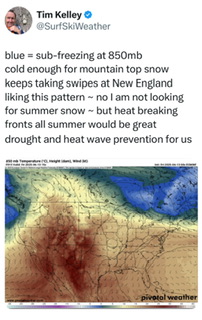
https://x.com/surfskiweather/status/1933493008810348748?s=46&t=096JqkIpgJTvSWddnDYqdA
- Today
-
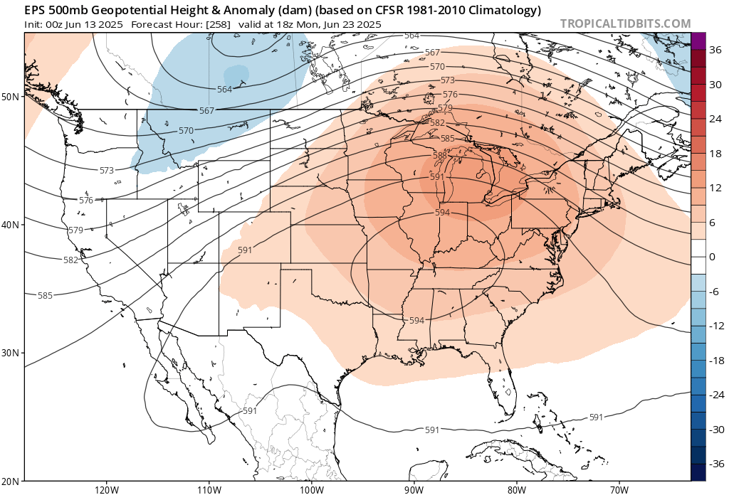
If the EPS is correct about that 594DM heat dome in around 10 days, then it would give us our first mid to upper 90s of the season.