All Activity
- Past hour
-
I'm currently in Clearfield. Definitely color up here. I was expecting that here, but Huntingdon is basically Kentucky climate-wise so seeing any color in late August was a bit of a shock. Cats are getting bulky already. They did that last year around this time and at least around here, the winter was kinda rough from December until February. Stayed cold until Spring but didn't get much snow. Seeing a lot of folks saying the winter is going to be backloaded this year and the clipper should return. I may be back up this way in a month or so just in time to deal with it.
-
You should probably flush the toilet.
-

September 2025 OBS-Discussion centered NYC subforum
JustinRP37 replied to wdrag's topic in New York City Metro
Big question is if this hurricane seasons stays this quiet. If so, then many tropical forecasts will bust. This is one of the slower starts in recent years and it still is quiet. That may change, but development looks to keep the fish busy. We will see, but so far a pleasant fall. -
Either one. If had to pick.. Sunday
-

September 2025 OBS-Discussion centered NYC subforum
bluewave replied to wdrag's topic in New York City Metro
The one lucky thing about that hurricane is that the surge occurred at low tide. So the actual tide level was similar to Sandy. But the surge was higher than Sandy which happened right at high tide. The rapid forward motion of the hurricane allowed the water level at the Battery to rise 13 feet in around an hour. Can’t even imagine what that would have been like in the era before weather forecasts. https://www.nature.com/articles/srep07366 While Hurricane Sandy was record breaking compared to published tide gauge records, earlier historical accounts suggest that a major hurricane in 1821 CE may have had a similar storm tide and a substantially larger storm surge5,7. During this 1821 hurricane the New Bedford Mercury newspaper reported a rise in water of 13 feet 4 inches or 4.06 m above low water in the East River4,6. The 1821 hurricane struck New York City at low tide with roughly 4.0 to 4.1 m of storm surge, compared to Sandy's 2.8 m of storm surge. Assuming this account is referenced to near the Battery, a 4.0 m storm surge would far exceed all events recorded within the instrumental tide gauge record, including Hurricane Sandy. Other flood descriptions support the 1821 hurricane as a significant flood event, including a 10 foot (3.0 m) rise in water level at Pungoteague, VA5, drift caught in the trees 9 feet (2.7 m) above the ground at Cape May, NJ5 and a tide several feet above normal at New London, CT6. Because peak flooding for the 1821 hurricane occurred at low tide, its storm tide was smaller than its overall surge. Ref. 7 estimated a storm tide of roughly 3.2 m for the event, which is slightly less than that observed for Hurricane Sandy at 3.4 m.
-
So, which day will be better to have a garage/yard sale in SE CT this weekend? Saturday morning or Sunday morning?
-
Back in the mid 90's, I was working at a sawmill, and we had flakes flying here in TH during the last week of Sept. That also heralded a rather cold winter. Not saying this would portend that, but definitely a cold start to Fall. Quote from DLH forecast discussion: The second cold front will bring a slightly more organized and persistent area of rain showers southeastward through the Northland today. Additional showers are likely behind that front as well this afternoon into tonight. As temperatures fall overnight, showers may become a mix of rain and snow. A thin coating of snow may survive through sunrise before melting shortly thereafter. Frost is possible overnight into Thursday morning, though clear skies and calm winds would likely be required.
-

September 2025 OBS-Discussion centered NYC subforum
SACRUS replied to wdrag's topic in New York City Metro
Records: Highs: EWR: 100 (1993) NYC: 99 (1929) LGA: 95 (1993) JFK: 93 (2015) Lows: EWR: 51 (1967) NYC: 50 (1893) LGA: 54 (1967) JFK: 62 (1967) Historical: 1815: A powerful hurricane made landfall near Swansboro, NC. Damage was extensive at Onslow with great loss of life. (Ref. Wilson Wx. History) 1821: A hurricane made landfall at Long Island, near Kennedy Airport, then moved through western Connecticut. The hurricane produced a record tide at New York City. An account from the Norfolk Herald described the storm as such..... From half past 11:00 until half past 12:00, so great the fury of the elements, that they seemed to threaten a general demolition of everything within their reach. During that period the scene was awful. There was the deafening roar of the storm, with the mingled crashing of windows and falling of chimneys, while the rapid rise of the tide threatened to inundate the town. The continuous cataracts of rain swept impetuously along darkening the expanse of vision and apparently confounding the heaven, earth and seas in a general chaos; together with now and then a glimpse caught through the gloom, of shipping forced from their moorings and driven with rapidity, as the mind might well conjecture in such a circumstance to inevitable destruction. (David Ludlum) The following is an account of what happened next from Howard Pyles, writtings: "...then a dull roar came nearer and nearer, and suddenly a solid mass of wind and rain and salt spray leaped upon the devoted island with a scream. Great pines bent for a moment, then, groaning and shrieking, were torn from their centuried growth like wisps of straw and hurled one against another; houses were cut from their foundations and thrown headlong; and then a deeper roar swelled the noise of the tempest, and a monstrous wall of inky waters rushed with the speed of lightning toward the island. It struck Assateague, and in a moment half the land was a waste of seething foam and tossing pine trunks; and the next instant it struck Chincoteague, and in an unbroken mass swept away men and ponies like insects; rushing up the island, tearing its way through the stricken pine woods." (Barnes & Truitt) At Pungoteage, a ten foot storm surge led to "unexampled destruction". Damage spread north with the storm into New York and New England over succeeding days. It was considered one of the most violent hurricanes on record... with damage totaling $200,000 in Virginia. Five drowned at Chincoteague. (Ref. for Long Island Hurricane of 1821) 1821 - A hurricane made landfall at Long Island, near Kennedy Airport, then moved through western Connecticut. The hurricane produced a record tide at New York City. (David Ludlum) 1821: Known as the 1821 Norfolk Long Island Hurricane, this storm ripped up the Mid-Atlantic and Northeast coast September 3 and 4 – coinciding with Labor Day (before the holiday was established). 1834: A strong hurricane made landfall near Georgetown, South Carolina. 1909: 48 °F in Washington, DC the first temperature of the season that was below 50 °F. (Ref. Washington Weather Records - KDCA) 1930: A Category 4 hurricane devastates the Dominican Republic on this day. This storm killed more than 8,000 individuals, which is it the fifth deadliest Atlantic hurricane on record. 1933: On this date through the 4th, there was extensive property damage on Florida's east coast from Vero Beach to West Palm Beach due to a landfalling hurricane. A few houses were destroyed and a number blown off their blocks. More than four million boxes of citrus were blown from the trees statewide. The property loss ran into the millions. Two deaths were attributed to storm. (Ref. Wilson Wx. History) 1953 - The temperature at Erie PA reached 99 degrees, and Stroudsburg PA established a state record for September with a reading of 106 degrees. (The Weather Channel) 1961 - Denver, CO, received 4.2 inches of snow, their earliest snow of record. (Sandra and TI Richard Sanders - 1987) 1970 - During the early evening hours, in the midst of a severe hailstorm at Coffeyville KS, a stone 17.5 inches in circumference and nearly two pounds in weight was recovered. It was the largest measured hailstone in U.S. weather records. Average stone size from the storm was five inches in diameter, with another stone reportedly eight inches in diameter. (David Ludlum) 1972: Hurricane Hyacinth moved as far west as 125 West before recurving to the northeast. The remnants made landfall between Los Angeles and San Diego, CA with winds of 25 mph and rainfall of up to one inch in the mountains from this day through 9/6. This tropical cyclone holds the distinction of traveling the farthest west before recurving and making landfall in Southern California. This occurred during the El Niño of 1972-73. (Ref. Wilson Wx. History) 1974: A strong Canadian air mass brought an early taste of Autumn extending the Plains to the Great Lakes & Ohio Valley. The earliest freeze on record in Sioux Falls, SD recorded their earliest freeze on record when they dropped to 31°. Other record lows included: North Platte, NE: 26°, St. Cloud, MN: 27°, Bismarck, ND: 28°, Valentine, NE: 30°, Aberdeen, SD: 31°, Huron, SD: 31°, Duluth, MN: 32 °F.(Ref. Many Additional Temperatures Listed On This Link) 1977: A 19-year-old hitch-hiker was struck and killed by lightning while leaning against a metal road sign on the southbound ramp of I-81 in Staunton, VA . Another person was injured. Witnesses said that there was no rain falling at the time and described the lightning bolt as having come "out of clear skies". In actuality, it came from a nearby thunderstorm. Also on this day in Poquoson, near hampton, Virginia around 6:20 PM, a man was struck and injured outside his home. During the period 1995 through 2000, there were seven lightning fatalities, 54 injuries and $6.5 million in damage, according to Storm Data. (Ref. Lightning - Virginia Weather History) 1979: Hurricane David made landfall in south Florida as a Category 2 storm. It caused 15 deaths in the US. Hurricane David was a Category 5 over the Dominican Republic were over 2,000 people died. 1987 - Temperatures dipped into the 40s and 50s for morning lows across much of the eastern half of the country, with eleven cities reporting record lows for the date. Pellston MI tied Gunnison CO for honors as the cold spot in the nation with a low of 30 degrees. Smoke from forest fires darkened skies in southern Oregon and northern California. (The National Weather Summary) 1988 - Sixteen cities in the northwestern U.S. reported record high temperatures for the date. Highs of 89 degrees at Stampede Pass WA and 116 degrees at Redding CA established records for the month of September. Readings of 98 degrees at Spokane WA and 100 degrees at Yakima WA equalled records for September. (The National Weather Summary) 1989 - Thunderstorms developing ahead of a cold front produced severe weather from Minnesota to Nebraska during the day and evening. Evening thunderstorms in Nebraska produced wind gusts to 100 mph at Valentine and Gretna, and produced baseball size hail at Lewellen. Thunderstorms in Arizona produced 2.20 inches of rain in forty minutes at Green Valley, and wind gusts to 60 mph. Eight cities in Texas and Florida reported record high temperatures for the date, including Victoria TX and San Antonio TX, each with a reading of 102 degrees. (The National Weather Summary) (Storm Data) 2002: A prolonged summer drought in southern Illinois gradually worsened, becoming severe by early September. Crop loss estimates totaled around $53 million dollars. The corn crop, which was especially susceptible to the combined effects of heat and drought, took the biggest hit. The remnants of Tropical Storm Isidore provided much-needed heavy rainfall late in September. (Ref. Wilson Wx. History) 2007: Key West, Florida: Key West records a record high reading of 95°F. This event is the first occurrence of a 95 °F or higher reading since August 1957. (Ref. WxDoctor) 2016: Tropical Storm Hermine made landfall in Florida on Friday, September 2, 2016 at 7:26 PM - as a Category 1 hurricane early Friday, leaving one dead and causing severe coastal damage in its wake. Hermine was the first hurricane to make landfall in the state since Wilma struck 11 years ago. It was only a Cat-1 hurricane but the rain in NC set the stage for a Major Flood with Matthew in October. 58,000 without power in Hampton Roads, Virginia The main problems in the Virginia Beach area was flooding -

September 2025 OBS-Discussion centered NYC subforum
steve392 replied to wdrag's topic in New York City Metro
Haven't personally been up that way in a very long time. Hopefully we can get some excursions like that again some day. -

September 2025 OBS-Discussion centered NYC subforum
MANDA replied to wdrag's topic in New York City Metro
I'd rather watch a 100GB file download on a 300 baud modem than watch this boring weather. SO BORING ! Very pleasant but very boring. - Today
-
Is there a map? Can you post it? Tia
-
White House having a flyover, could be related to that
-
September 2025 OBS-Discussion centered NYC subforum
SACRUS replied to wdrag's topic in New York City Metro
76 / 55 another great day. Warmer more humid Thu - Sat, storm chances Fri/ Sat as front moves through. Mid - upper 80s, we'll see if the hottest areas with enough sun can touch 90 for the first time since Aug 17th on Fri/Sat.v A bit cooler Sunday - Wed before overall warmer pattern beyond there. -

September 2025 OBS-Discussion centered NYC subforum
IrishRob17 replied to wdrag's topic in New York City Metro
That’s a great location if you haven’t already been there. I got some decent photos/ VHS videos of the 614 in the late 1990s when it would run to Port Jervis. Sad to see Ross Rowland passed away but glad the 614 is in new hands and getting an overhaul at the Strasburg shop. Oh no, I’ve gone into the weeds again. 74/58 under sunny skies after a low of 48. -

2025 Atlantic Hurricane Season
BarryStantonGBP replied to BarryStantonGBP's topic in Tropical Headquarters
I’m trying to get the article because it said I can get it for free in the app but a phone number is required to read it and British phone numbers are blocked for verification bloody hell -

Occasional Thoughts on Climate Change
donsutherland1 replied to donsutherland1's topic in Climate Change
Several quick things: 1. Neither explains the amount of energy that would be required for volcanic activity to have been driving the heating of the oceans 2. Neither can explain why the warming is top-down not bottom up 3. When it comes to SSTs, 2025 has been running either 2nd or 3rd warmest. Day-to-day fluctuations are less important than the overall trajectory. Indeed, their SST chart contains a material omission that shows that the steep drop was, in fact, a fluctuation. 4. No credible or compelling evidence is used to support the following statement: "The Sun, the oceans, stochastic events, and the very design of the system far overwhelm anything man can do to the climate and weather..." Bottom line: The scientific evidence related to the warming oceans is consistent with what would be expected from enhanced greenhouse gas forcing. Some cooling of the oceans would be expected from ENSO. Oceanic heat content continues to increase. CO2's properties are independent of whether CO2 is released from volcanic activity or human activities. Those properties are the same regardless of how it is released into the atmosphere.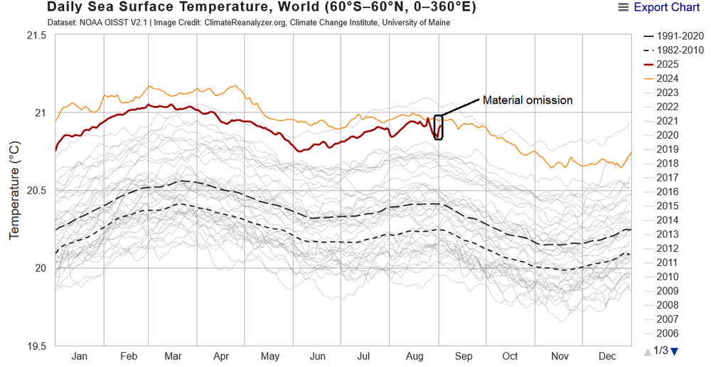
-

September 2025 OBS-Discussion centered NYC subforum
Stormlover74 replied to wdrag's topic in New York City Metro
Only til Saturday evening then dews plummet and Sunday on look gorgeous -
September 2025 OBS-Discussion centered NYC subforum
Stormlover74 replied to wdrag's topic in New York City Metro
Same here to my surprise because I wasn't expecting it to be good. It was also an earlier than normal peak. I was thinking a 2007 repeat where we peaked just before Thanksgiving -

September 2025 OBS-Discussion centered NYC subforum
forkyfork replied to wdrag's topic in New York City Metro
you see one orange hillside and you've seen them all -
-

2025 Spring/Summer Mountain Thread
Buckethead replied to Maggie Valley Steve's topic in Southeastern States
56 with heavy rain currently in South Toe. There's a noticeable amount of leaf color change this morning. Sent from my SM-S908U using Tapatalk -
September 2025 OBS-Discussion centered NYC subforum
steve392 replied to wdrag's topic in New York City Metro
Hoping this year will match last years. I wanna get up that way for some foliage pics with Moodna Viaduct. -
September 2025 OBS-Discussion centered NYC subforum
IrishRob17 replied to wdrag's topic in New York City Metro
I noticed you said ‘extra’ dry fall, not sure exactly what you mean but the dry fall isn’t the potential issue IMO. A drier fall typically allows for a more vibrant and longer lasting show. A dry summer could have impacts though. That said, there are a many variables. Timing is huge too and each little microclimate can have its own peak. Not sure when you went to Bear Mountain last year, or how their season was overall, but up here it was one of the better seasons in years. To be fair though, the previous few seasons sucked.


.png.8e340af4307eb6926b026cedb629dab9.png)