All Activity
- Past hour
-
Snow for our back yards verbatim
-

January 2026 regional war/obs/disco thread
ORH_wxman replied to Baroclinic Zone's topic in New England
That New years weak clipper is trying to get slightly enhanced in eastern areas. Wonder if someone can pick up a couple inches. Still just expecting a coating but 1-2 isn’t impossible. -
Looks nice. The Greenland block is moving WSW by early Jan. As for specifics, just be happy we have a chance to score in the coming weeks.
-
We’re building towards cross polar flow on almost the entire 12z suite
-

Ice Ice Baby December 28-29 Storm Discussion
rimetree replied to Baroclinic Zone's topic in New England
Up to 41F here this morning and now leveled off around 37-38F with 0.63" of rain so far. Still some coverage in the yard that will likely just turn into a skating rink tonight. -
Rain per this run but doesn’t matter
-
Id that’s rain we’re done forever
-
Its all good my brother. Your quality contributions always outweigh the negative ones. The fact is, we all love snow and we all are tired of disappointment.
-
Nope. It's a nice hit.
-
I spiked up here, up to 41 now.
-
So do the 12z Canadian ensembles.
-
RE: 12z Canadian Move the antedecent high pressure just 200-400 miles west and that storm at HR 240 is a KU event.
-
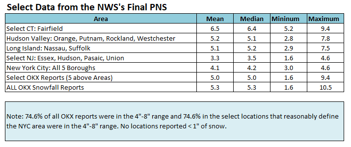
I had used the initial map posted by MJO812 for the benchmark. Even with the adjustment for the the additional snowfall, the outcome changes very little. The NAM has had successes. This wasn't one around the New York City area, which was the focus of the discussion/model comparison, when it came to snowfall amounts leading up to the storm. The HRRR overdid some of the totals for New York City and Newark. It seems to have a cold bias. In the end, over several days of guidance, it was clear that this was going to be a 3"-6"/4"-8" storm for the New York City area. There was no real drama for this area. The RRFS A's attempts at suppression, NAM's swings/amounts for NYC-EWR, and GFS's elevated amounts were noise. IMO, this was probably among the more straightforward forecasting situations in recent snowstorms for the City and its nearby suburbs. That outcome shows up well in NWS-New York's (OKX's) final PNS report where almost 75% of all snowfall reports fell in the 4"-8" range and nearly two-thirds were in the 3"-6" range. This will be my last comment on the NAM for the December 26-27 storm. The numbers speak for themselves.

-
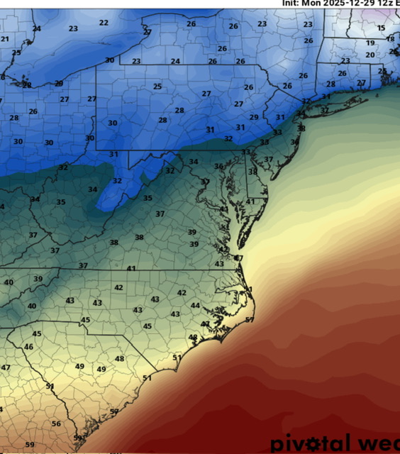
Wind advisories expanded into OKX forecast area: Northern Fairfield-Northern New Haven-Northern Middlesex-Northern New London-Southern Fairfield-Southern New Haven-Southern Middlesex-Southern New London-Western Passaic-Eastern Passaic- Hudson-Western Bergen-Eastern Bergen-Western Essex-Eastern Essex- Western Union-Eastern Union-Orange-Putnam-Rockland-Northern Westchester-Southern Westchester-New York (Manhattan)-Bronx- Richmond (Staten Island)-Kings (Brooklyn)-Northwest Suffolk- Northeast Suffolk-Southwest Suffolk-Southeast Suffolk-Northern Queens-Northern Nassau-Southern Queens-Southern Nassau- 1243 PM EST Mon Dec 29 2025 ...WIND ADVISORY IN EFFECT FROM 4 PM THIS AFTERNOON TO 6 PM EST TUESDAY... * WHAT...West winds 15 to 25 mph with gusts up to 50 mph expected. * WHERE...Portions of southern Connecticut, northeast New Jersey, and southeast New York. * WHEN...From 4 PM this afternoon to 6 PM EST Tuesday.
-

January 2026 regional war/obs/disco thread
Typhoon Tip replied to Baroclinic Zone's topic in New England
yeah, honestly I'll leave that to y'all. I do wonder where we are when that erstwhile 1/3 season-length resonant -WPO breaks down... I hunch there's a window of opportunity there for at least a transient +PNA. That's obviously thus of unknown magnitude. You know what this reminds me of... high A1C. The body is swimming, in fact ...drowning is apropos, in high octane energy but it's can't use it. It's like the hemisphere is a suffering Prediabetic. There's no real comparative or metaphoric value to that, but it just leaps to mind because I'm bored with nothing else to do ... but it fits in with my Cosmos is just an analog engine in disguise. I see circumstantial metaphors all the time. Like, the AGW stuff? classic hypertension. My mind has fun with circumstantial comparisons. To much partying and the host body ends up polluted, their metrics go up.. On Earth? Humanity's been on this harbor cruise party since 1780 and the IR (Industrial Revolution).... It's just that in geological time span, the metaphor takes a helluva lot longer. In 2026...it is like 1.5 hours into the party cruise, and the wooziness is just kicking in. We'll see if the idiot has the sense to come back to the dock, or if they end up on an O.D. OR at the ER just havin' fun -

January 2026 regional war/obs/disco thread
Great Snow 1717 replied to Baroclinic Zone's topic in New England
Sort of like saying a 2 year old is going to be a great NFL QB... -
Guess we could see a quick spike in temps before they start falling again
-

Ice Ice Baby December 28-29 Storm Discussion
VivaManchVegas replied to Baroclinic Zone's topic in New England
If you have a generator and a wood stove, its all fun and games. I would hate to go through it with out the right tools. -

E PA/NJ/DE Winter 2025-26 Obs/Discussion
RedSky replied to LVblizzard's topic in Philadelphia Region
44F highest temp in this weak torch and still have ice -

January 2026 regional war/obs/disco thread
Ginx snewx replied to Baroclinic Zone's topic in New England
You know the odds for a 12 inch storm and say its not anomalous for 15? Just can’t -
Ice Ice Baby December 28-29 Storm Discussion
VivaManchVegas replied to Baroclinic Zone's topic in New England
GYX just updated our high temps, down a few degrees and realigned with current temperature readings. The last update had us a 39 degrees at this time period. High was supposed to be 41. Now calling for snow showers this afternoon. Thats new.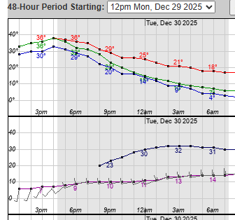
-

January 2026 regional war/obs/disco thread
40/70 Benchmark replied to Baroclinic Zone's topic in New England
I think these balks at committal are hiccups. -
Clearing line working its way slowly east
-
Looks like highs were adjusted down to low 40s
-
January 2026 regional war/obs/disco thread
40/70 Benchmark replied to Baroclinic Zone's topic in New England
I would be shocked if we don't see January average a +PNA in the mean.