All Activity
- Past hour
-

November 2025 general discussions and probable topic derailings ...
dendrite replied to Typhoon Tip's topic in New England
Probably graupel/small hail? This is probably the heaviest burst of rain I had all warm season. -

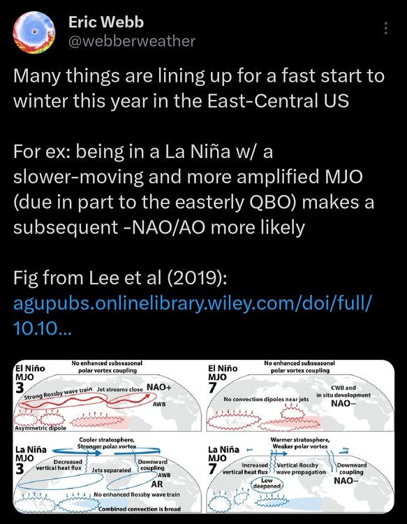
2025-2026 ENSO
Stormchaserchuck1 replied to 40/70 Benchmark's topic in Weather Forecasting and Discussion
Some long range confusion on the long range GEFS right now. It's the only model that has a strong MJO Phase 7 wave occurring But it's developing a -PNA look You guys are keeping track of this more than I am.. Has strong Phase 7 in late November been hard to happen the last several years? -
Looking at mid 30's for us next week. Could be our first frost and freeze if it runs colder. That is early for us. Usually doesn't get that cold until 3rd or 4th week of November.
-

November 2025 general discussions and probable topic derailings ...
alex replied to Typhoon Tip's topic in New England
Pouring rain and lightning here! Crazy weather -
Cool and rainy day here. Low of 51, high of 60. Picked up .42" today and .09" yesterday. Sun managed to come out after 3 pm.
-
Playing Cocheco Country Club in Dover, NH tomorrow. Should be pretty interesting considering the wind gust forecast.....
-
Thank god it's dark by 5PM now. I can come out of my coffin an hour earlier now.
-

2025-2026 ENSO
40/70 Benchmark replied to 40/70 Benchmark's topic in Weather Forecasting and Discussion
I think the predominate MC forcing constructively interferes there, whereas it decontructively interferes with +PNA in conjunction with the enhanced Pac jet. -

November 2025 general discussions and probable topic derailings ...
wxeyeNH replied to Typhoon Tip's topic in New England
47F Just had a quick heavy shower with lots of sleet. -
2025-2026 ENSO
Stormchaserchuck1 replied to 40/70 Benchmark's topic in Weather Forecasting and Discussion
We've had a good amount of PNA blocking (-PNA). December 2021 shattered records in this regard. -NAO's have not sustained at all. 15 days or less then it always goes back to neutral or positive, since I think 11-12. The 60s and 70s were not like that at all. EPO has also come in short periods, but that is more typical of the region to be like that than the NAO. -
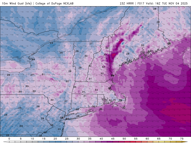
Wind advisory potential continues Wednesday night...40-50 MPH gusts, near 60 briefly on the ridges. Power outages of some sort return. Might need some predawn Thu detours to destinations. Not sure of the power outages count Wed night... not major but not nil either. Blowout tide potential both low tides Thu as we move into lunar larger tide cycles. No thread til or if OKX issues.
-
It’s been a challenge maintaining strong enough 500mb blocking across the WPO, EPO, PNA, and TNH regions. The last time we pulled this feat off was January 2022. Last winter the block kept getting undercut and eroded from the very fast Pacific Jet sending shortwaves through. So this continued the Great Lakes cutter, I-78 to I-84 hugger, and suppressed Southern Stream storm tracks.
-
Hechinger's

-
A lot of energy guys more bullish after first week of December. Seem to think weeklies aren’t out to lunch. Hopefully they’re right.
- Yesterday
-
We'll want to eradicate those lower heights near AK as we get deeper into November....lots of low heights up there over the first half or 2/3rds of November on the ensembles and weeklies. Euro weeklies have been insistent on pushing them out by late November, which would be a good sing for a fast start, but always watch for the delayed pattern shift. Sometimes it's rushed.
-
The only problem is these cold shots are always outdone by the warmups. Even without a ridge over the northeast it seems like our base state is slightly above normal. Feels like it takes a lot to get some colder air lately
-
Some seasons I’m sure different, but between further north latitude out east, less development and longitude I’d say yes
-
Mt Pleasant, CMU student?
-
Over the past 30 years? Maybe I'm just bitter but I remember a large number of coastals that destroyed LI and only grazed NYC during the last 20 years, has the difference always been that much?
-

-

-
I lived in SF for five years, 1990 - 1995. Squad Valley was where we went, when we did. Enjoy, it is...sick out there.
-
Upton and areas out there average at least 5” more.
-
Mountains get a decent hit and it’s cold enough something might fly over. it’s nice to even be looking
-

2025 Atlantic Hurricane Season
WxWatcher007 replied to BarryStantonGBP's topic in Tropical Headquarters