All Activity
- Past hour
-
I’ve went into my full July irrigation schedule here. Even with it, this is probably the worst the lawn has looked in April in years. I have Texas Bluegrass that spreads with rhizomes like Bermuda and its repairing ability has completely stalled out these past few weeks.
-
Back from Rehoboth just before all the Running Festival folks flood the town. Tried the new DFH 120 on draft. If you like massive hops start to finish this is the one for you. I was a bit disappointed overall, and especially coming off last years edition, which had the complexity associated with the huge/sweet malty backbone this beer is known for, plus the dry hopping for the first time that gave it a nice finish. The intense hoppiness in the new edition overwhelms the characteristic malty backbone too much imo. That said give it a try- true hopheads might love it. What I have always loved about it though, is the complexity and the balance.
-

2026-2027 El Nino
LakePaste25 replied to Stormchaserchuck1's topic in Weather Forecasting and Discussion
I imagine summer in the east will be on the milder, wetter, and more humid side -
57.6° - Not bad if we can approach 60 That extra 5-7 degrees in this sun makes a difference
-

2026-2027 El Nino
snowman19 replied to Stormchaserchuck1's topic in Weather Forecasting and Discussion
Big signal for a strong +IOD development this summer, which will constructively interfere with El Niño -
Also, there is much more to it than what the charts show. Structure/placement of the anomalies are more important than the raw value itself. A -NAO/-AO doesn't always equate to blocking. In that graphic, the NAO is largely forecast to be more of a weak signal with larger spread towards the end of guidance (typical), albeit the AO is forecast to be a bit more in the way of negative. Based on an evolution of the 500 pattern (at least on 12z GFS) one could argue the greatest potential for cooler temperatures associated with any negative AO would be northern Plains.
-
SST's in Cape Cod bay are still in the low 40's. Going to be a while before anyone is safe along the coast.
-
I don't want to even entertain snow for 6 months.. After Halloween it's welcome back
-
Yup. They’re straight trash . Indicies mean Jack dick once out of Winter
-
Beautiful afternoon. Looking forward to a firepit and a beer later on.
-
Look at those d10 and d14 graphs...they've been verifying on the upper end of the model spread for awhile now.
-

2026-2027 El Nino
TheClimateChanger replied to Stormchaserchuck1's topic in Weather Forecasting and Discussion
Looks like good, sound records to me. The snowfall and liquid equivalents make sense. -
it is the accuracy of the record keeping from back then. It isn't a lie, but most likely not accurate. It could have even been more snow, but I'd question it no matter what.
-
2020's here, like 30 miles away from Newark, is 29.2. 2010s I was 35.9, so Newark did better. They have had some bad luck this decade with snow cutoffs. 1840s-60s is mostly nonsense.
-
Hi michael
-
2026-2027 El Nino
TheClimateChanger replied to Stormchaserchuck1's topic in Weather Forecasting and Discussion
What motive would they have to lie about how much snow fell? Newark is not the same climate as Detroit. It could have been colder and drier in Detroit than present. -
67 70 next door at KFIT with rounding
-
Heh... we can't look at it this way. We can't categorize and package these up as go or no, based on seasons. If there is blocking in the right place, it will be cold in July. Nothing more or less. People have ( likely ) made conjecture like this in the past, but honestly ...we have to take it case by case. There may be more blocking in winter then summer. Okay, but if the blocking is over eastern Canada... not sure summer protects us from cooler anomalies.
-
65 here.
-
Typically cold highs with NE flow and especially if there is precip. It's a climo feature at some point in Spring....it's just that some Springs are worse than others.
-
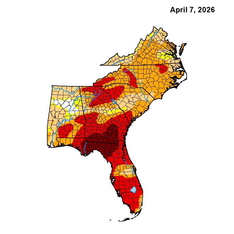
I’ve been sprinkling the yards recently. The drought in this area and especially to the SW is about the most severe in the entire SE with widespread D3 (extreme) here to D4 (exceptional) in SC GA to NC FL. See map below. Although it’s unpredictable, the good news is that a strong El Niño appears to be on the way. If that verifies, much of the SE should see wet relief by November based on history and long range models:
- Today
-
@Stebo

-
That's the other thing-even a -NAO in late April does it really bring the cold?
-
I haven't seen an actual spring cut off like we used to do in the mid 2000s probably since then. The last time was a cut-off on 'roids: May 2005. It wasn't "a" cut-off. It was an initial variant, that kept getting a new N stream parcel loading into the backside. The first in the series weakened and acted like it was going to beta-drift away, but then the reload grabbed it and it retrograded. This recurred a couple more times. So it was kind of like 4 consecutive ones with lull pauses between them. Staying cold. No sun. Each one was more loaded with "o'reah" than Montezuma's Revenge. Actually ... from a purely Meteorological dorkatudal-doo it was a pretty spectacular. There was IP and mangled aggregates mixed at times up in the Worcester Hills. There were three or four different accelerations of the NEesterly wind field during each re-invigoration of the coastal storm that would rotate back when said parcels reloaded. Winds gusted 45 mph. Sheets of 38 to 44F rain... The whole thing took like 2.5 to 3 weeks to finally kick out. Lesser, singular events with a cut-off in April were more common in the 1980s and '90s. Seems we've had a dearth of those in last decade?
-
Unless your swimming or at the beach the heat is pointless. Never understood how People like it.. 60 to 70 would be perfect in summer..