All Activity
- Past hour
-
the month is November 2048. i’m outside in my ClimoSuit Sponsored by Palantir enjoying another 110 degree day—the dew point is only 73 so i can lift the face shield to get a whiff of fresh air. i look down at my iPhone 42. metfan has just posted a 480 hour kuchera ratio snow map from the Sri Lankan model
-
Maybe BDL can hit 115 HI ?
-
94 to 100 is a big difference for climate control systems, as well as grid stability, that's my biggest concern.
-
Finally!!! I hope we end this rainy crap with a huge bang...lol
-
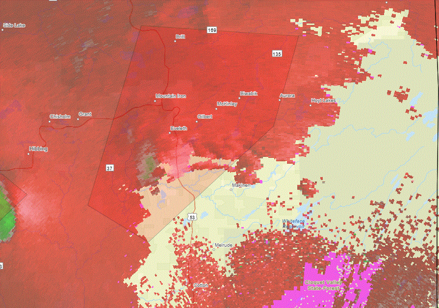
N one going right over Eveleth. Hope it's not on the ground.
-
Agree. 94 or 100, zero difference, just like -5 or 0.
-
Possible two tornadoes near Hibbing (one previous tornado by Aitkin MN)
-
Tornado sig near the Iron Range area of NE MN, which is NW of me. 2 possible tornadoes in the area up that way with this one more defined.
-
dry heat is better than humid heat I keep thinking to July 2010, 101 with 45 dew point so refreshing.
-
I had a few more drops.
-
Same here
-
If the ridge gets too steep it’ll turn our winds southerly and the worst heat will overshoot our area again. Still plenty of time for that to happen.
-
it’s so beautiful outside next week i will die
-
Dr Mary Jane can help you.
-
Too far out to know exacts but the latest GFS has more onshore flow than the Euro next week, so it has lower temps (mid to upper 90's) with higher humidity. Unfortunately it's been the theme of a lot of our heat waves in recent times
-
I was born and raised in this kind of weather. I'll be fine! (Just kidding. It was only like 72 degrees outside and once the sun came out I was suffering. I know you all like to make fun of me, but I think the low heat tolerance is probably medication related, and yes, I'm talking to my doctor about getting off of said medication).
-
Nothing Sat and about 0.2" between last night and today. Did some planting and watered everything yesterday so the gentle rain on top has been nice. Plants visibly enjoying.
-
Today was awesome. High around 80F. Dews in mid-50s. Sun.
-
.01 through the tipper. I was actually getting concerned because I had gone 24 hours without a trace not thankfully some showers moved through.
-

2025 summer max contest -- enter by 06z June 20
tplbge replied to Roger Smith's topic in Mid Atlantic
DCA: 102 IAD: 100 BWI: 101 RIC: 101 -
It will become somewhat warmer tomorrow with highs reaching the lower 70s. By Wednesday, the mercury will likely reach 80°. A sustained period of above normal temperatures will then develop by midweek. No exceptional heat appears likely through the first three weeks of June. However, that could change shortly afterward if some of the extended range guidance is correct. Excessive heat is possible starting early next week. The ENSO Region 1+2 anomaly was +0.5°C and the Region 3.4 anomaly was 0.0°C for the week centered around June 11. For the past six weeks, the ENSO Region 1+2 anomaly has averaged +0.30°C and the ENSO Region 3.4 anomaly has averaged -0.05°C. Neutral ENSO conditions will likely continue through at least late summer. The SOI was -12.72 yesterday. The preliminary Arctic Oscillation (AO) was +0.731 today. Based on sensitivity analysis applied to the latest guidance, there is an implied 69% probability that New York City will have a warmer than normal June (1991-2020 normal). June will likely finish with a mean temperature near 73.5° (1.5° above normal).
- Today
-
Have we had any doors this year? Next week maybe?
-
That last two years i got boned every rain event so this year seems to be making up for it a bit. I'm sure the curse of Stephens City isn't far away
-
As an after thought the 80F in some Febs and Marches over the last 20 years may qualify … but part of climatology is the time of year. There may be circumstantial limitations (physically) that prevent really truly gaudy I-95 buck.10s that aren’t there in the earlier spring


