All Activity
- Past hour
-
Early data for Aug showing an avg month. A warmer summer again driven by the warmth of June, and July. 5 & 10 yr trend charts shown respectively.


-
Very dense fog this AM. Airport has had visibility around a quarter mile.
-

September 2025 OBS-Discussion centered NYC subforum
psv88 replied to wdrag's topic in New York City Metro
Upton has a dry weekend east of the city. -
-

2025-2026 ENSO
40/70 Benchmark replied to 40/70 Benchmark's topic in Weather Forecasting and Discussion
I think it's one of the more helpful teleconnectors in terms of individual storms, but I would take the -EPO for starters during a given season....getting a vortex over AK is the kiss of death for any season. -
Looks hot the next two weeks through maybe Wed. Sept. 25 but mercifully humidity should be low to moderate. Only drawback with low RH is the drought will get worse in the Mid-South and western half of our region. Drought might even spread east. Not as hot east, but still dry. -GLAAM favors the warm pattern. While the ECMWF weekly is warm forever (what's new?) the CFS drops a Great Lakes trough at the end of the month, somewhat helped by a slight +PNA. Even with the GLAAM situation even a slightly +PNA can allow the said trough. CFS makes sense to get our region's temps back to normal. Euro weekly has a similar 500 mb pattern with a Midwest trough. It's west of the CFS trough axis; so, the Euro keeps the Southeast warm. Gonna have to disagree though. With normal heights, surface cool fronts should make it. Sure it'll be a day later than progged, but FROPA will happen. Bottom line: I have to go with the CFS milder late Sept. Hard spot: I figure drought could expand east more than CPC shows. We'll see. Little NW flow surprises like today might mitigate such a thing.
-

September 2025 OBS-Discussion centered NYC subforum
wdrag replied to wdrag's topic in New York City Metro
I agree with you but overall, the EC AI did not buy into the initial Sunday-Monday EC EPS closed low aloft scenario...admittedly as we mentioned... highly unusual pattern evolution. I am curious as to the multiple ensembles with sct showers Saturday (FOUS has LGA 90% RH at 60 hours 00z Sun) and it still looks like sct or widespread showers ahead of the seed moving short wave Sunday. Middle of next week might also have closed low feature in mid ATLC. For now will monitor what might transpire. -
And the best late summer/early fall rolls on.
-
Agree...
-
Wow, nice shots! My favorite up that way is Jay Peak, but growing up and later in life I have been to Stowe more than several time. Always appreciate the photos!
-
+PNA is king. I think it's probably the best predictor of weather the I95 gets a snowy pattern compared to all other teleconnections.
-
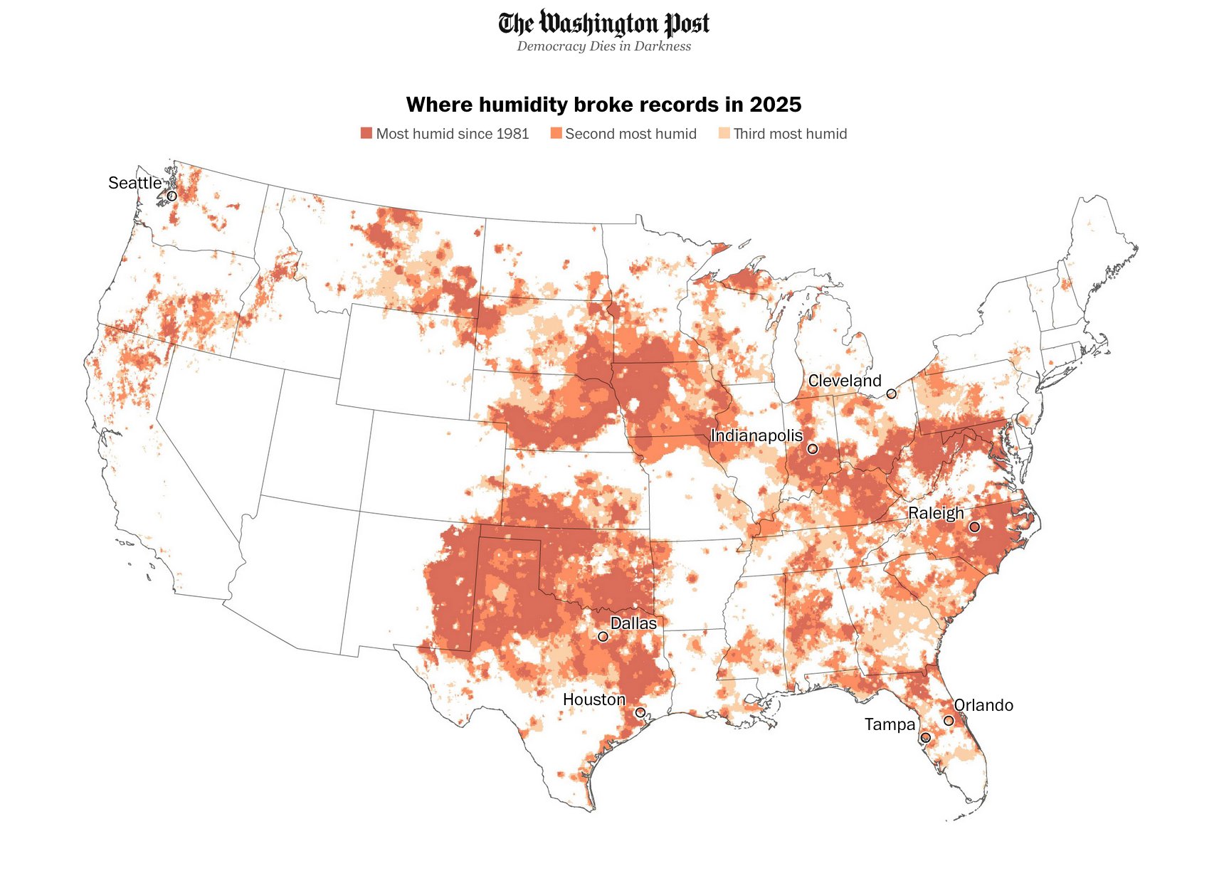
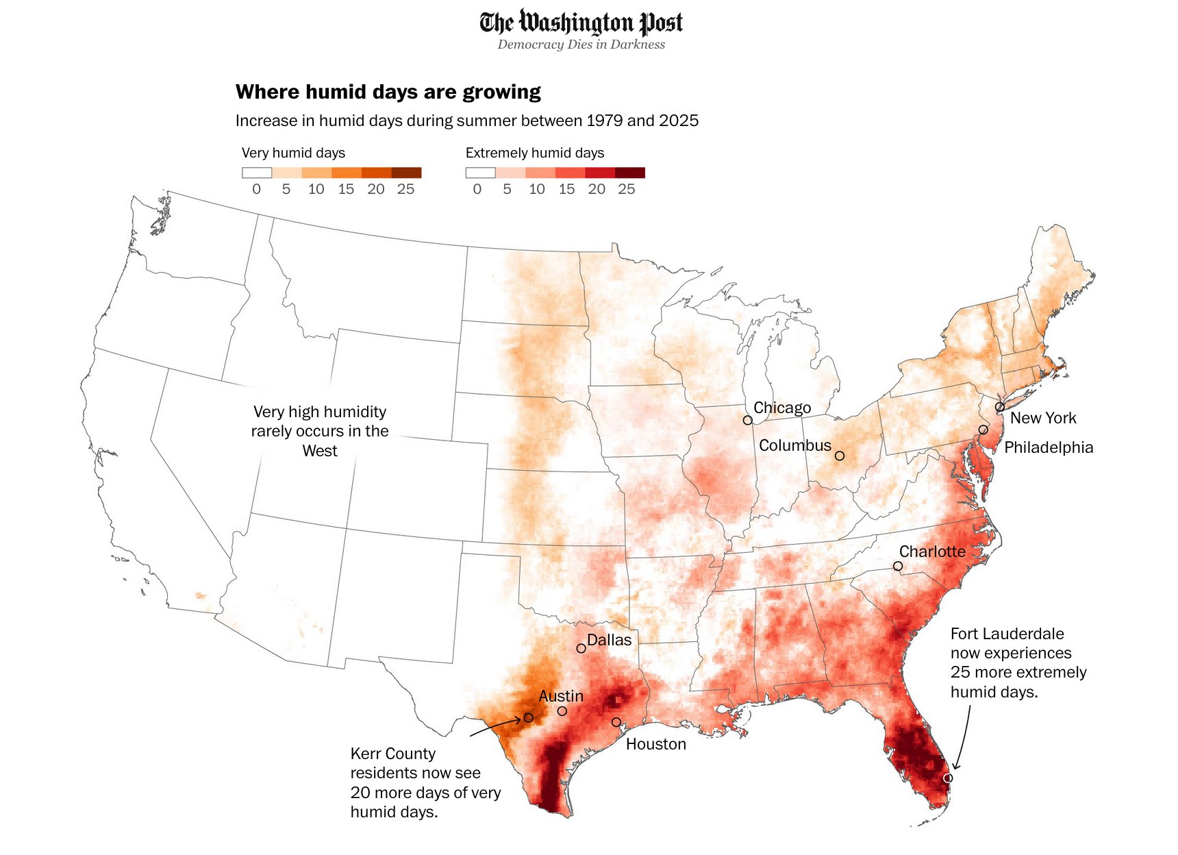
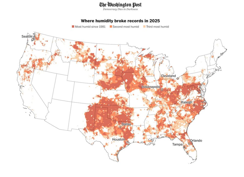
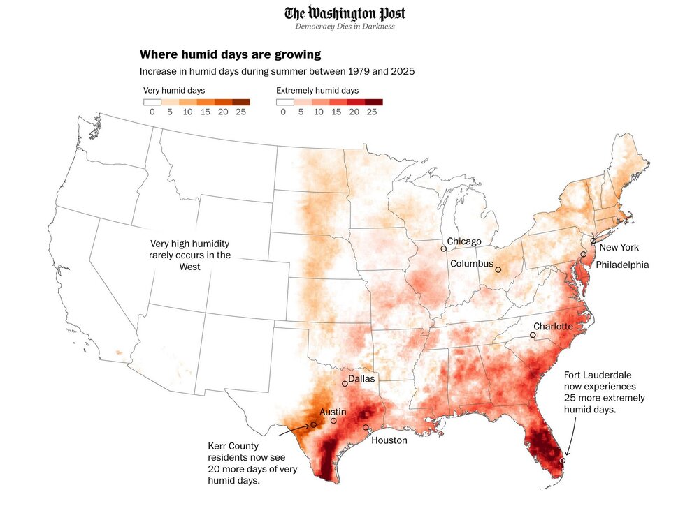
Interesting detailed thread about how humid it was this summer across some of the states. I mean I could just tell even without anyone telling me how humid it was this year lol https://x.com/BenNollWeather/status/1966133621145612602
-
An overcast, drizzly morning. Blah wx today.
-
I think there can start to be some positive feedback, but it's defintely not the primary catalyst. Agreed.
-
Yes, but it will be interesting to see how much that is mitigated by the west PAC.
-
Was going to overseed this weekend. So sick of Stein making me water the lawn the past few months.
- Today
-
-
Remember a few years ago when NNE was drowning and we were practically dust in SNE? Weird how nature works
-
Yep !
-
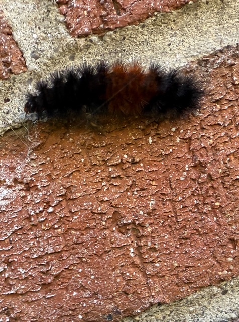
About 20 years ago (I'm guessing) an entomologist in Maine researched the critters and found that there was a significant (barely) relationship between the color bands and the subsequent winter. (Probably the above relationship - I don't remember. And I think it compared snow or snow/cold for full winters, without the early/late connection.) Slowly warming minima here - 34 on Tuesday, 36 yesterday, 38 this morning. Forecast suggests tomorrow morning will go the other way.
-
2025-2026 ENSO
40/70 Benchmark replied to 40/70 Benchmark's topic in Weather Forecasting and Discussion
You absolutely nailed that...full credit. While my outlook went up in flames, it was one of the more instructional experiences that I have had in seasonal forecasting. This is why I always say the ones that are missed are our most valuable resources. We saw something similar with the 1972-1973 El Nino, but obviously this was warmer given CC. I think this year we may see something similar in that seasonals will overbake ENSO into the output. -
44 to 71 in just under 3 hours that's like desert recovery rates there
-
That’s why during the fall of 2023 I was pointing out the WPAC to IO would have more influence than we typically get with such strong El Niños. It lead to me doubting the Euro seasonal forecast of the typical Nino trough with colder conditions in the Mid-Atlantic and Southeast. The ridging in Canada was also stronger and more extensive than we typically see with El Niño events building down into the East which we usually see with La Ninas. So effectively a hybrid pattern with the warmest features of an El Niño and La Ninas merged together. We got early hints this would be the case back in May 2023 when the historic ridge developed over Canada leading to the record wildfire season. So there are clearly multiple areas of record SST warmth contributing to the overall pattern. In the old days we could just look at Nino 3.4 and have a reasonable assumption of what the pattern would look like. Now as I have been saying we have to deal with competing influences from these numerous areas of record SST warmth. This has been one of the reasons these seasonal models have been having so much of a challenge with the recent winter forecasts. The stock El Niño and La Ninas composites from the colder climate era are not manifesting in the same ways anymore. We first got a sample of this when the El Niño forecasts in 2018-2019 and 2019-2020 failed to couple due to the record SST warmth from the IO into the WPAC.
-
I have a feeling that's the case again for today. Wait for cool dry air in this area is like watching paint dry while it's drizzling.
-
It's so dry..it's so dry...sooo dry.. He moves in mysterious ways.