All Activity
- Past hour
-
Yeah, Chill Special on this run.
-

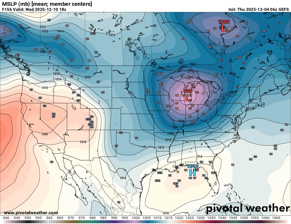
The Return of the 12/5 Snowstorm
SomeguyfromTakomaPark replied to SnowenOutThere's topic in Mid Atlantic
GFS is nice, lets keep the good trends going. Feeling better about seeing some snow. -
Gfs is north and juicy. Pummels @Bob Chill to RIC.
-
Also got down to -8 here in Grinnell. Snowpack helps. Like the trends for the clipper.
-
I'm still rooting for Tomer Berg to be right
-
GFS not too bad. Gets about an inch up to DC via crappy SV maps...precip shield looks a bit norther
-
haha you should've been here last January, we had almost a foot in a 24hr span.
-

December 2025 regional war/obs/disco thread
ma blizzard replied to Torch Tiger's topic in New England
sad times .. this must be how the late 80s / early 90s felt feels like a region wide 3"-6" would be a KU storm at this point -
Only your first wife.
-
.thumb.jpg.ad3a2e31d30aff035044689b311a0540.jpg)
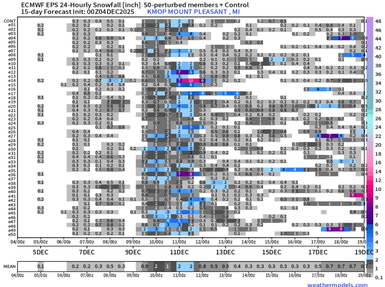
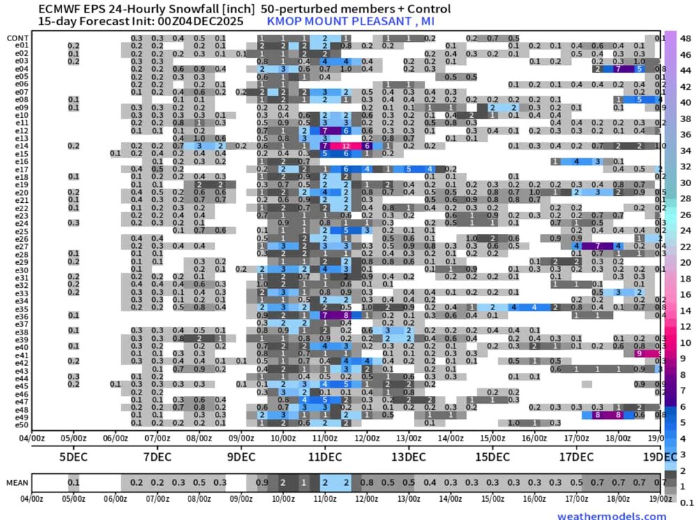
Winter 2025-26 Medium/Long Range Discussion
nvck replied to michsnowfreak's topic in Lakes/Ohio Valley
Eyeing next tuesday-wednesday-thursday for the next possible system of note around here. GRR mentions a lot of uncertainty, but the west ridge being a little more amplified should allow for a sw or two to ride the ridge down to the GL area and maybe bring a couple inches of snow. Would be a nice send-off from Michigan EPS 24hr snowfall very cluttered in that timespan but that 2nd system, late on the 10th-11th, has been uptrending a little bit the past few runs.
-
GFS will be a nudge north.
-

December 2025 regional war/obs/disco thread
Damage In Tolland replied to Torch Tiger's topic in New England
That’s all I’ve got -
December 2025 regional war/obs/disco thread
ma blizzard replied to Torch Tiger's topic in New England
yeah too bad the GFS is the only model on board for that one .. 1"-3" would feel like a SECS -
December 2025 regional war/obs/disco thread
Damage In Tolland replied to Torch Tiger's topic in New England
Grab a few at the party. What could go wrong? -

December 2025 regional war/obs/disco thread
40/70 Benchmark replied to Torch Tiger's topic in New England
I initially though Wankum was just lazy and dumbing things down, but the more I listen, the more I feel he really believes that. He is consistently emphatic about it. -
Icon and RGEM meh with Sunday night into Monday though
-
Most guidance shifted east with the notoriously fickle inverted trof for Saturday. Can't rule out flurries or snow showers now through Saturday but hard to envision any accumulation ATM. Medium-range models show a parade of potential "threats" but nothing tangible yet. The longwave flow is broadly supportive of wintry threats. The Sun-Mon clipper is first up. Feels like winter... especially in areas with a little snow cover (not far NW of NYC as seen on satellite).
-
Winter 2025-2026 Offers Return to Normalcy
40/70 Benchmark replied to 40/70 Benchmark's topic in New England
Yea, it was a marginal warning event....but I feel it was warranted given first even to the season. February of an active winter....maybe not. -
December 2025 regional war/obs/disco thread
ma blizzard replied to Torch Tiger's topic in New England
RGEM has been consistently showing C-1" from the norlunish feature on Saturday .. not much but would be nice for the areas that were shutout on Tuesday -

The Return of the 12/5 Snowstorm
NorthArlington101 replied to SnowenOutThere's topic in Mid Atlantic
With all the love I have for the NWS I can't get with the high-end snow map. Uniquely terrible - minus for weenie entertainment - and if the purpose is to inform EMS/other partners about a "realistic" worse case scenario they fail miserably. The computer generated 8-12" corridors and the water-driven enhancement makes no sense. -

December 2025 regional war/obs/disco thread
Typhoon Tip replied to Torch Tiger's topic in New England
Mmm it matters in shoulder seasons. March bombs for ex definitely benefit from a diabatic heat flux -

December 2025 regional war/obs/disco thread
SnowGoose69 replied to Torch Tiger's topic in New England
I always mention the April 2000 NY snow event where ALB went from 78 to 14 inches next day and it mostly fell from 8am-2pm too in mid April -

December 2025 regional war/obs/disco thread
powderfreak replied to Torch Tiger's topic in New England
Crushing snow. Mansfield stake depth at #1 all-time (since 1954) for the date at 47”.


-

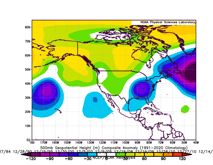
2025-2026 ENSO
donsutherland1 replied to 40/70 Benchmark's topic in Weather Forecasting and Discussion
Here's the data for New York City: Below are the composite 500 mb anomalies for WPO<0 December cases for 4" or more daily snowfall. To date, the guidance does not suggest the kind of pattern shown below. It should also be noted that snowfalls tend to be light during the first half of December when the AO/NAO/PNA are all negative.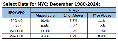
-
I plan doing a little chasing but I think the RDU folks have moved on otherwise.